Sold2017Hand drawn map of the world, Eastern and WesternHand drawn map of the world, Eastern and Western Hemisphere, executed by Marta Maxwell August 13, Lebanon, August 31, 1814. sight size: 16" x 21 1/2"See Sold Price
Sold2022A. Dunsford, hand-drawn world map, 1859A. Dunsford, hand-drawn world map, 1859, A. Dunsford (19th c., likely American), ink, gouache and watercolor on paper, mounted on linen, dated "Xmas 1859" and marked "A. Dunsford - Wellington Academy"See Sold Price
Sold2021French Map of the World Decorative ArtsFrench Map of the World, piece appears to be hand drawn and colored, inscriptions to piece in French, label to reverse reads ‘Le Normand, Charles 14 x 19 Manuscript World Map’, subject a map of thSee Sold Price
Sold2021Spherical Coin Seven Wonders"Seven New Wonders of the World" is the first spherical coin minted by Mint of Poland. Based on the hand-drawn XVII-century map created by the Dutch cartographer Willem Janszoon Blaeu. process. ThanksSee Sold Price
Sold2023Schoolgirl Map of the World, Hannah Edgerton, Franklin, New York dated 1828"A Map of the World Drawn by Hannah Edgerton, Cairo Seminary December 27, 1828. E. Stimson, Preceptress." These hand-drawn and colored "school girl" maps were a far more common in the boarding and finSee Sold Price
Sold2020Becker, F. C1838 Antique Map. World on Mercator's Proj.Steel Engraved Map with outline hand color Published C1838, London for "A Complete and Universal English Dictionary" by the Rev. James Barclay et al. Maps by F. Becker and others. Paper Size: 10.5 x 8See Sold Price
Sold2020Becker, F. C1850 Antique Map. World on Mercator's Proj.Steel Engraved Map with outline hand color Published C1850 "A Complete and Universal English Dictionary" by the Rev. James Barclay et al. Maps by F. Becker and others. Paper Size: 10.5 x 8 inch (27 xSee Sold Price
Sold20211873 World MapAuthor: Bartholomew Title: 1873 World Map Medium: Ink on Paper Dimensions: 18"X13.5" World map dated 1873. Drawn on Sir J. Herschel's Projection. Part of Zell's Descriptive Hand Atlas of the World. PuSee Sold Price
Sold2023Becker, F. P. C1845 Antique Map. World on Mercators ProjectionSteel Engraved Map Published C1845, London for "A Complete and Universal English Dictionary" by the Rev. James Barclay and B. B. Woodward. Maps by F. P. Becker. Outline hand color. Paper Size: 11 x 8See Sold Price
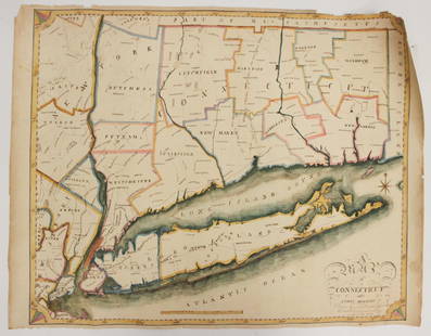
Sold2023EARLY CONNECTICUT MAPHand drawn and colored; "Connecticut and Parts Adjacent", "drawn by Miss. Elizabeth L. Tredwell" "Christ Church Academy 1820", several edge tears; 23" x 30", F-GSee Sold Price
Sold2022Barclay & Becker C1845 Map. World of MercatorsSteel Engraved Map Published C1845, London for "A Complete and Universal English Dictionary" by the Rev. James Barclay and B. B. Woodward. Maps by F. P. Becker. Outline hand colour. Paper Size: 10.5 xSee Sold Price
Sold2024Russell, J. 1804 Antique Map. World HemispheresCopper Engraved Map with outline hand color Published 1804 by W. Peacock, London for "A Compendious Geographical Dictionary" Drawn and Engraved by J. Russell. Folds as issued. Paper Size: 6.5 x 5 inchSee Sold Price
Sold2021Scarce map of N. Amer. - T. Ettling, 1875Large and impressive hand-colored map of the North American continent. Found in the very scarce Jones and Hamilton Atlas of the World Illustrated, published 1875 by H. H. Hardesty. This map, drawn bySee Sold Price
Sold2016Map of the World. 1854.Print of hand colored steel engraving titled „Mappemonde Physique et Politique”.Drawn by L. Dussieux. Engraved by unknown.From „Atlas General De Geographie physique, politique et historique parSee Sold Price
Sold2021Large hand colored map of Asia, 1875Large vintage map of Asia in the not-often seen hand-colored version. Most likely drawn by A. K. Johnston, and appearing the very scarce Jones and Hamilton Atlas of the World Illustrated, published 18See Sold Price
Sold2023F. Gray's Idaho, Montana and Wyoming Map 1870Featured in this lot is an excellent, hand-colored early map of Idaho Territory, Wyoming Territory and Montana Territory, published by O.W. Gray and drawn by Frank A. Gray. Wyoming is shown with onlySee Sold Price
Sold2021THE MAYHEW FAMILY TREE LITHOGRAPHHand colored noting Thomas as Governor and Patentee of Martha's Vineyard, Nantucket and Elizabeths Islands, drawn by F. Mayhew, 1826, sight size: 20 x 26 1/2 inches, framed: 22 3/4 x 29 inchesSee Sold Price
Sold2017THOMAS HART BENTON LETTER, HAND DRAWN MAP, ETCAutographs, drawing, photos and ephemera from the estate of Kansas City writer and photographer Bob Barrett (1943- 2016) relating to his personal experience with Kansas City artist Thomas Hart BentonSee Sold Price
Sold2017HAND DRAWN MAP OF "HARDENBURGH PATENT GRANTED INYEAR 1704" COMPILED & LAID DOWN FROM ACTUAL SURVEY (47" X 57 1/2")See Sold Price
Sold2022Early Hand Drawn Map of United States in 1817,by Mary Young, image area 20" X 30" plus frame.See Sold Price
Sold2022[MANUSCRIPT MAP-MAINE] After DES BARRES, JOSEPH FREDERICK WALLET. Hand-drawn map of a portion of the[MANUSCRIPT MAP-MAINE] After DES BARRES, JOSEPH FREDERICK WALLET. Hand-drawn map of a portion of the Maine coast off Falmouth, copied from Des Barres. Likely early 19th century. Manuscript map in blacSee Sold Price
Sold202219th Century Hand-Drawn Map of NY, PA, MD, NJ, DEHistoric Maps 19th Century Original Hand-Drawn Regional Map of New York, Pennsylvania, Maryland, New Jersey, and Delaware 19th Century Hand-Drawn Regional Map of New York, Pennsylvania, Maryland, NewSee Sold Price
Sold202219th c. Hand Drawn Map19th c. hand drawn map. Marked "A / MAP / OF THE / UNITED STATES / DRAWN / BY / LEONARD ATWATER / MARCH 1824". Sight 15 3/4" x 19 1/2", overall 19" x 22 1/2".See Sold Price
Sold2022HAND DRAWN MAP OF THE UNITED STATES.Ca. 1912, pen and ink, watercolor on ledger paper. "Drawn by M.C. Killian", the continental United States. The back of the paper has a paragraph about livestock hooves by Alice E. Bechtel, Reamstown,See Sold Price
3 days LeftMynt AuctionsNotre Dame Rudy Ruettiger Signed F/S Speed Rep Helmet w/ Hand Drawn Play BAS Wit$10
May 16Potter & Potter AuctionsBOUCHER, Lucien (1889 – 1971). Provence Breguet 763 / Air F...$300
4 hrs LeftTrillium Antique Prints & Rare BooksMitchell's A New Universal Atlas.. - Volume with 73 Maps$1,000(1 bid)
May 11Fichter KunsthandelJ. BRETHERTON (18th) after BUNBURY (*1750), Caricature, French Courier, Etching€150


![[MANUSCRIPT MAP-MAINE] After DES BARRES, JOSEPH FREDERICK WALLET. Hand-drawn map of a portion of the: [MANUSCRIPT MAP-MAINE] After DES BARRES, JOSEPH FREDERICK WALLET. Hand-drawn map of a portion of the Maine coast off Falmouth, copied from Des Barres. Likely early 19th century. Manuscript map in blac](https://p1.liveauctioneers.com/292/250642/130213649_1_x.jpg?height=310&quality=70&version=1654271664)


