Sold2015A New Map of the East IndiesTaken from M. de Fer's Map of Asia by Edward Wells (1667-1727), circa 1700, hand-colored map was part of a set of 22 maps dedicated to William, Duke of Gloucester, title cartouche includes the Royal CSee Sold Price
Sold2019Wells, Edward 1817 Map of Asia Showing ParadiseCopper Engraved Map Published 1817, London for "A Companion to the Holy Bible; The Sunject, Sacred Geography..." by Edward Wells. Paper Size: 10.5 x 8 inch (27 x 21cm) Good ConditionSee Sold Price
Sold2019Wells, Edward 1817 Antique Map of AsiaCopper Engraved Map Published 1817, London for "A Companion to the Holy Bible; The Sunject, Sacred Geography..." by Edward Wells. Paper Size: 10.5 x 8 inch (27 x 21cm) Good ConditionSee Sold Price
Sold2023Group of MapsMAPS. - [Edward WELLS]. A New Map of the Most Considerable Plantations of the English in North America. [Oxford: c. 1700]. Engraved map, hand-colored in outline. Wide margins (sheet size: 17.5 x 22.25See Sold Price
Sold20202 Maps of Asia2 Maps of Asia- 1). John Cary- ''A New Map of China, From the Latest Authorities''- engraved map, 1801, some minor staining in margins. 18 1/2 x 20 1/2'' 2). John Thomson- ''Corea and Japan''- engraveSee Sold Price
Sold2020(2) HANDCOLORED MAPS OF ASIABurma, Siam, French Indo-China and Straits Settlements and Physical Map of Asia . Dimensions: H 9.75" x W 12.75" Condition: Folding, toning and a tear to the middle of the Map of Asia.See Sold Price
Sold2017Edward Wells, map North AmericaEdward Wells, map North America, Edward Wells (British, 1667-1727), "A New Map of North America Shewing its Principal Divisions, Chief Cities, Townes... Dedicated to His Highness William Duke of GloucSee Sold Price
Sold2020Edward Wells Map of South America ca. 1700-1738Edward Wells (1667–1727), engraved by Benjamin Cole, "A New Map of South America, Shewing it's General Divisions, Chief Cities & Towns; Rivers, Mountains & c," London, ca. 1700-1738. Hand colorSee Sold Price
Sold2020Edward Wells Map of Africa 1738Edward Wells (1667-1727), "A New Map of Africk Shewing its Present General Divisions Cheif Cities or Towns, Rivers, Mountains &c," London, ca. 1738. Hand colored map of Africa. With an elaborately decSee Sold Price
Sold2021Edward Wells Map of South AmericaEdward Wells United Kingdom,1667-1727 Map of Mexico by Edward Wells and engraved by Benjamin Cole 1695-1766, includes a dedication in the print to Prince William, Duke of Gloucester. Impression area 1See Sold Price
Sold2020Edward Wells Map of Ancient Greece, Thrace, MoesiEdward Wells (1667–1727) "A New Map of Antient Greece, Thrace, Moesia, Illyricum, and the Isles adjoyning," London: J. and J. Bonwicke, S. Birt, T. Osborne, E. Wicksteed and T. Cooper, ca. 1726See Sold Price
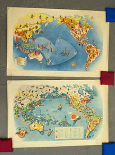
Sold2021Covarrubias Pacific Asia Pictorial Maps (2)Maps of the Pacific, Golden Gate International Exposition. NY, 1942. Miguel Covarrubias (1904-1957). 2 Maps: Peoples and Economy. Australia, Hawaii, Asia, Americas. .See Sold Price
Sold2023Lot of 2 Africa, Asia Maps 1808-1809. Size 13 1/2 x 10 1/2 inches lengthLot of 2 Africa, Asia Maps 1808-1809. Size 13 1/2 x 10 1/2 inches length. The map shows Africa way before the infamous expedition by John Hanning Speke to the source of the Nile.See Sold Price
Sold2019Wells, Edward 1817 Maps of Israel (3) Holy Land"Travels of Israel, in the Wilderness" "A Map of Canaan" "A Map of Canaan, adapted to the Book of Genesis" Copper Engraved Map Published 1817, London for "A Companion to the Holy Bible; The Sunject, SSee Sold Price
Sold2023Lizars, Daniel 1831 LG Rare HC Map. Asia on 2 SheetsLarge Folio Copper Engraved Map Published 1831-2 by John Hamilton, Successor to Daniel Lizars, Edinburgh for "The Edinburgh Geographical and Historical Atlas..." First Edition by Daniel Lizars. Very fSee Sold Price
Sold2019Wells, Edward 1817 Map of Africa. Ham SettlementsCopper Engraved Map Published 1817, London for "A Companion to the Holy Bible; The Sunject, Sacred Geography..." by Edward Wells. Paper Size: 10.5 x 8 inch (27 x 21cm) Good ConditionSee Sold Price
Sold2019Wells, Edward 1817 Map of Europe. Japhet SettlementsCopper Engraved Map Published 1817, London for "A Companion to the Holy Bible; The Sunject, Sacred Geography..." by Edward Wells. Paper Size: 10.5 x 8 inch (27 x 21cm) Good ConditionSee Sold Price
Sold20182 Maps: Stato Del Gran Turco + Asia Minoris.[De Rossi/Middle East] 2 Maps. ++ Stato Del Gran Turco diviso ne suoi Beglierbati, o Governi, e ne Principati, che li sono Tributari. Elaborate map of the Middle East, including Greece, Italy, the CasSee Sold Price
Sold2018EDWARD WELLS (ENGLISH, 1667-1727) MAP OF NORTH AMERICAEDWARD WELLS (ENGLISH, 1667-1727) MAP OF NORTH AMERICA, hand-colored, on laid paper, cartouche in upper left corner lettered in part "A New Map of NORTH AMERICA / Shewing its Principal Divisions, ChieSee Sold Price
Sold2022Edward Wells A New Map of South America, 1700Edward Wells (1667-1727), engraved by Benjamin Cole, "A New Map of South America Shewing its General Divisions, Chief Cities & Towns; Rivers, Mountains & c.", London, circa 1700, hand colored engravedSee Sold Price
Sold2019Wells, Edward 1817 Antique Map of EuropeCopper Engraved Map Published 1817, London for "A Companion to the Holy Bible; The Sunject, Sacred Geography..." by Edward Wells. Paper Size: 10.5 x 8 inch (27 x 21cm) Good ConditionSee Sold Price
Sold2019Wells, Edward 1817 Antique Map of AfricaCopper Engraved Map Published 1817, London for "A Companion to the Holy Bible; The Sunject, Sacred Geography..." by Edward Wells. Paper Size: 10.5 x 8 inch (27 x 21cm) Good ConditionSee Sold Price
Sold2024Stanford, Edward 1901 Large Map. AsiaLarge Folio Lithograph Map Published 1901, London for "Stanford's London Atlas of Universal Geography" by Edward Stanford. Centre fold as published. Paper Size: 29 x 21.5 inch (74 x 55cm) Good ConditiSee Sold Price
Sold2023TWO ANTIQUE AFRICAN MAPS.Early hand colored engraved map of North Africa by Edward Wells, ca. 1700, “A New Map of the North Part of Antient Africa..” image 14.25” x 19”, overall 22” x 27”.See Sold Price
7 days LeftJasper52Scenes in Rome and the Vatican, Entrance to the Taj Mahal, temples in India and Thailand. By$20
BonhamsGIBBON (EDWARD) The History of the Decline and Fall of the Roman Empire, 6 vol., FIRST EDITION o...£700
6 days LeftMark Louis Weseloh Estate LiquidationsSix - 17th c. Maps of Europe, Asia, England, Germany x2, Crete, Greece.8 1/4" x 6 5/8".$300
BonhamsBLAEU (WILLEM AND JAN) Toonneel des Aerdrycz, oft Nieuwe Atlas... Tweede Deels, 2 parts in 1 vol...£8,000
BonhamsSOCIETY FOR THE DIFFUSION OF USEFUL KNOWLEDGE The Complete Atlas of Modern, Classical and Celest...£1,800
BonhamsBOTERO (GIOVANNI) Le relationi universali... novamente ristampate, & ricorrette -Aggiunta alla q...£5,000
Jun 15Crescent City Auction GalleryPair of New Orleans Sanborn Fire Insurance Mock-Up Skeleton Maps of the French Quarter, 1910-1911,$250
3 days LeftTrillium Antique Prints & Rare BooksDonovan's The Natural History of British Shells - 5 Volumes in 2 Books with 180 Engravings$400
BonhamsLEWIS (WYNDHAM, EDITOR) Blast. Review of the Great English Vortex, No. 1 (of 2), John Lane, 20 J...£10


![Group of Maps: MAPS. - [Edward WELLS]. A New Map of the Most Considerable Plantations of the English in North America. [Oxford: c. 1700]. Engraved map, hand-colored in outline. Wide margins (sheet size: 17.5 x 22.25](https://p1.liveauctioneers.com/3975/301526/160694339_1_x.jpg?height=310&quality=70&version=1694182765)


![2 Maps: Stato Del Gran Turco + Asia Minoris.: [De Rossi/Middle East] 2 Maps. ++ Stato Del Gran Turco diviso ne suoi Beglierbati, o Governi, e ne Principati, che li sono Tributari. Elaborate map of the Middle East, including Greece, Italy, the Cas](https://p1.liveauctioneers.com/179/117971/60557726_1_x.jpg?height=310&quality=70&version=1520636872)


