Sold2020Edward Wells Map of South America ca. 1700-1738Edward Wells (1667–1727), engraved by Benjamin Cole, "A New Map of South America, Shewing it's General Divisions, Chief Cities & Towns; Rivers, Mountains & c," London, ca. 1700-1738. Hand colorSee Sold Price
Sold2022Edward Wells A New Map of South America, 1700Edward Wells (1667-1727), engraved by Benjamin Cole, "A New Map of South America Shewing its General Divisions, Chief Cities & Towns; Rivers, Mountains & c.", London, circa 1700, hand colored engravedSee Sold Price
Sold2021Edward Wells Map of South AmericaEdward Wells United Kingdom,1667-1727 Map of Mexico by Edward Wells and engraved by Benjamin Cole 1695-1766, includes a dedication in the print to Prince William, Duke of Gloucester. Impression area 1See Sold Price
Sold2020Edward Wells Map of Africa 1738Edward Wells (1667-1727), "A New Map of Africk Shewing its Present General Divisions Cheif Cities or Towns, Rivers, Mountains &c," London, ca. 1738. Hand colored map of Africa. With an elaborately decSee Sold Price
Sold2021Wells map of South America c.1700Heading: Author: Wells, William Title: A New Map of South America, Shewing it's General Divisions, Chief Cities & Towns; Rivers, Mountains &c Place Published: London Publisher: Date Published: <See Sold Price
Sold2023TWO ANTIQUE AFRICAN MAPS.Early hand colored engraved map of North Africa by Edward Wells, ca. 1700, “A New Map of the North Part of Antient Africa..” image 14.25” x 19”, overall 22” x 27”.See Sold Price
Sold2023Group of MapsMAPS. - [Edward WELLS]. A New Map of the Most Considerable Plantations of the English in North America. [Oxford: c. 1700]. Engraved map, hand-colored in outline. Wide margins (sheet size: 17.5 x 22.25See Sold Price
Sold2017Edward Wells, map North AmericaEdward Wells, map North America, Edward Wells (British, 1667-1727), "A New Map of North America Shewing its Principal Divisions, Chief Cities, Townes... Dedicated to His Highness William Duke of GloucSee Sold Price
Sold2023Edgar Wells Engraved 'Map of South America'Engraved Map of South America originally drawn by Edgar Wells in 1701 to accompany his Treatise of Ancient and Present Geography. Includes original receipt and paperwork. Measures 16.75"H x 21.75"W. CSee Sold Price
Sold2018EDWARD WELLS (ENGLISH, 1667-1727) MAP OF NORTH AMERICAEDWARD WELLS (ENGLISH, 1667-1727) MAP OF NORTH AMERICA, hand-colored, on laid paper, cartouche in upper left corner lettered in part "A New Map of NORTH AMERICA / Shewing its Principal Divisions, ChieSee Sold Price
Sold2020Edward Wells Map of Ancient Greece, Thrace, MoesiEdward Wells (1667–1727) "A New Map of Antient Greece, Thrace, Moesia, Illyricum, and the Isles adjoyning," London: J. and J. Bonwicke, S. Birt, T. Osborne, E. Wicksteed and T. Cooper, ca. 1726See Sold Price
Sold2019E. Wells, "Texas /California (front), Western DivisionE. Wells, "Texas /California (front), Western Division of the U.S. (inside Map), South America (back)," 1856, hand colored, H.- 22 in., W.- 13 1/2 in.See Sold Price
Sold2019Bryce, James 1881 Group of 3 Maps. South AmericaLithograph Maps Published 1881, London for ""The International Atlas and Geography..." by James Bryce. Maps by Edward Weller & John Bartholomew. Uncommon. Paper Size: 18 x 13 inch (46 x 33cm) Good ConSee Sold Price
Sold2022Mapuche Stone Mask - Fine ExamplePre-Columbian, South America, Argentina or Chile, Mapuche Culture, ca. 1200 to 1700 CE. If ever there was a mask that captured the element of surprise, this one is it! A remarkably rare mask, finely cSee Sold Price
Sold2018Mapuche Stone Maskette - Astonished ExpressionPre-Columbian, South America, Argentina or Chile, Mapuche Culture, ca. 1200 to 1700 CE. If ever there was a mask that captured the element of surprise, this one just might be it. A very rare, finely cSee Sold Price
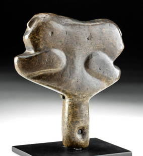
Sold202113th C. Mapuche Shaman's Stone Clava / ScepterPre-Columbian, South America, Argentina or Chile, Mapuche culture, ca. 1200 to 1700 CE. A hand-carved stone ceremonial scepter known as a clava that was suspended from the wrist of a shaman via a knotSee Sold Price
Sold2023Mapuche Stone Maskette**First Time At Auction** Pre-Columbian, South America, Argentina or Chile, Mapuche Culture, ca. 1200 to 1700 CE. An evocative maskette, hand-carved from stone with simplistic yet haunting characterisSee Sold Price
Sold2023Lifesize 13th C. Mapuche Stone MaskPre-Columbian, South America, Argentina or Chile, Mapuche Culture, ca. 1200 to 1700 CE. An evocative maskette, hand-carved from stone with simplistic yet haunting characteristics: ovoid, openwork eyesSee Sold Price
Sold2021Ancient Manabi Vessel with Avian designs 500 BCA very rare ancient terracotta clay vessel with stylized anthropomorphic face , wonderful stylized form as well as charming incised avian designs. Manabi culture, Ecuador, South America ca 500 BC - 50See Sold Price
Sold2019MAP - Northern South America. SansonNorthern South America. Nicolas Sanson, Terre Ferme, Nouveau Royme de Grenade, &c., 1700 (circa). Hand Color. Very attractive small map of the northern part of South America, including most of modernSee Sold Price
Sold2017Levasseur: Map of South America, 18401840 Levasseur Map of South America - Amerique Meridionale. A very decorative South America continental steel engraved map. Good topographical and political boundary details are shown as well as a popSee Sold Price
Sold2024Carey & Lea: Post-revolutionary South America, 1823Title/Content of Map: Carey & Lea: Post-revolutionary South America, 1823 Date Printed: 1823, London Cartographer: Carey & Lea Size: 7 3/8" x 9 5/8" A detailed and well colored map of post-revolutionaSee Sold Price
Sold2020Nicolas Sanson Atlantis Insula Map Hand Colored ENicolas Sanson (1600-1677), "Atlantis Insula," Amsterdam: Mortier, ca. 1700. This wonderful hand colored engraving map of America purportedly shows the Western Hemisphere about 200,000 years ago beforSee Sold Price
Sold2021Hall, Sidney 1852 Pair of Maps of North & South AmericaSteel Engraved Map Published 1852, London for "A Grammar of General Geography..." by the Rev. J. Goldsmith & Edward Hughes. Folds as issed. Maps by Sidney Hall. Paper Size: 8 x 6 inch (21 x 16cm) VerySee Sold Price
May 15University ArchivesDeclaration of Independence, Very Early British Publ. in Gentleman's Magazine & Rare Map$1,000
6 days LeftKCM GalleriesLarge Detailed Original Oil Painting United States Map Julius Lira Salazar 48 x 36 inches$1,800
6 days LeftTremont Auctions18th century original map of South America. "Charles Earl of Sunderland and Baron Spencer. This Map$150(1 bid)
May 15University ArchivesScarce Early Printing: "An Account of the European Settlement in America in 6 Parts..."$100
May 16Potter & Potter AuctionsPOLAND, Edwin Christian (1903 – 1991). The Evergreen Playgr...$200
May 12Schilb Antiquarian Rare Books1869 ATLAS 42 MAPS America Africa Australia GERMANY Switzerland Sydow RARE$130(3 bids)
2 days LeftDoyle New YorkA remarkable unpublished manuscript of a voyage to South America in 1759-1764$1,500
2 days LeftAdam's AuctioneersH.C CAREY AND I.LEA (publishers) A Complete Historical, Chronological and Geographical AMERICAN€1,500(1 bid)
21 hrs LeftWillow Creek Coin & CollectiblesKanya Bugreyev (CA, 1936-2019) “Bear Creek, Yosemite”, Oil on Board.$25(1 bid)
May 07Freeman's | HindmanKENNEDY, Edward Moore. America Back on Track. INSCRIBED BY THE AUTHOR TO ALBRIGHT.$100
May 12Ararity AuctionsHuge 8' Polychrome Paint Decorated Carved Wood Mirror/Headboard Frame w/Dove Birds-Scrolling Roses$100(1 bid)


![Group of Maps: MAPS. - [Edward WELLS]. A New Map of the Most Considerable Plantations of the English in North America. [Oxford: c. 1700]. Engraved map, hand-colored in outline. Wide margins (sheet size: 17.5 x 22.25](https://p1.liveauctioneers.com/3975/301526/160694339_1_x.jpg?height=310&quality=70&version=1694182765)