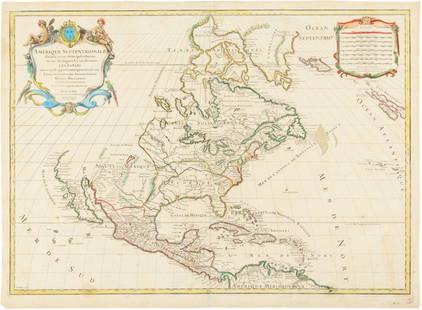
Sold2016Hubert Jaillot. Amerique Septentrionale diviséeHubert Jaillot. Amerique Septentrionale divisée en ses principales parties<See Sold Price
Sold2017Jaillot: Antique Map of North America, 1696Map: 1696 Jaillot Map of North America (California as an Island) -- Amerique Septentrionale Divisee en ses Principales Parties Date Printed: 1696 Amsterdam Cartographer: H. Jaillot Size: 19.3 x 23 in.See Sold Price
Sold2020Seale map of North America California an islandHeading: Author: Seale, Richard William Title: A Map of North America with the European Settlements & whatever else is remarkable in ye West Indies, from the latest and best Observations Place PublisSee Sold Price
Sold2024Seale map of North America California an islandHeading: (North America) Author: Seale, Richard William Title: A Map of North America with the European Settlements & whatever else is remarkable in ye West Indies, from the latest and best ObservatioSee Sold Price
Sold2020Hubert Jaillot Map South America 1719Hubert Jaillot (1632-1712), "Amerique Meridionale divisee en ses pricipales Parties ou sont distingues les uns des autres les Estats suivant qu'ils appartiennent presentement aux Francois, Castillans,See Sold Price
Sold2021Maps of North America, California, and the Great LakesMaps of North America, California, and the Great Lakes RegionSee Sold Price
Sold2023(NORTH AMERICA.) Henricus Hondius. America Septentrionalis.(NORTH AMERICA.) Henricus Hondius. America Septentrionalis. Double-page engraved map of North America with California as an island and attractive carto-ornamentation. 19¼x23½ inches sheet siSee Sold Price
Sold2017van der Aa: T Noorder deel Vaa Amerika, 1707Map: T Noorder deel Vaa Amerika Maker: Peiter van der Aa Date: 1707 Description: Map of North America with California shown as an island. Many place names on California's west coast Size: 8 x 11.8 incSee Sold Price
Sold2018Extremely RARE. North America with California as aTitle/Content of Map: Extremely RARE. North America with California as a island Date: 1717 Size: 7.6x10.6†By Feuille published in 1717, Amsterdam. One of the rarest maps to acquire of the contineSee Sold Price
Sold2020Jacques Chiquet North America Map 1719 CaliforniaJacques Chiquet (1673-1721), "L'Amerique Septentrionale qui fait partie des Indes Occidentales," Paris, 1719. This excellent hand colored map of North America includes a depiction of California as anSee Sold Price
Sold20201798 Monterey California North America MapTitle: Plan de la Baie de Monterey" - Monterey California North America map Karte Amerika Atlas du Voyage de la Perouse. Published: by G.G. & J. Robinson, Pater-noster Row. Size: Artwork: 10 x 15 1/2See Sold Price
Sold2022JOHN SENEX CALIFORNIA AS ISLAND 1720 ENGRAVED MAPOriginal engraved map of North and South America featuring California depicted as an island. Dimensions: (Frame) H 24.25" x W 27.75" (Sight) H 20" x W 23.25" Condition: Paper with center fold as issueSee Sold Price
Sold2022(AMERICAS.) Herman Moll. A Map of America According to ye Newest and Most Exact Observations.(AMERICAS.) Herman Moll. A Map of America According to ye Newest and Most Exact Observations. Engraved map of North and South America showing California as an island. 11½x7¾ inches sheet sizSee Sold Price
Sold2022Early Map of North AmericaEarly Map of North America Showing numerous Indian Tribes and California as a peninsula. Cartographer: Samuel Walker - Boston Dated: Circa 1830's - 40's<See Sold Price
Sold2023AMERICA H. Moll Geographer 1732 MapHerman Moll 1732 Map of the Americas, North and South America with California depicted as an island. Hand Colored engraving 8 1/2 x 11 in Matt.See Sold Price
Sold2018North America Sheet Xv Utah, New Mexico, Texas,Title/Content of Map: North America Sheet Xv Utah, New Mexico, Texas, California, &C. and the Northern States of Mexico. Date: 1852 Cartographer: Society for the Diffusion of Useful Knowledge/ S.D.U.KSee Sold Price
Sold2020Hondius' North America California an IslandHeading: Author: Hondius, Henricus Title: America Septentrionalis Place Published: Amsterdam Publisher: Date Published: 1636-[1639] Description: Copper-engraved map, lightly hanSee Sold Price
Sold2020Sanson's North America, California an islandHeading: Author: Sanson, Guillaume Title: Amerique Septentrionale Place Published: Paris Publisher:Chez Pierre Mariette Date Published: 1669 Description: Copper-engraved maSee Sold Price
Sold2023NORTH AMERICA. Texas Republic. Mexican California. Russian America SDUK 1851 mapTITLE/CONTENT OF MAP: 'NORTH AMERICA' The borders printed on the map reflect national boundaries as they existed between 1836 and 1845 during which period the map was engraved, including the RepublicSee Sold Price
Sold2024A rare dated 1722 North America mapA rare dated 1722 North America map, the map covers Mexico, California to Florida, condition fair, 21.2"x25"See Sold Price
Sold2021MOLL, HERMAN. America.MOLL, HERMAN. America. Engraved folding map of North and South America showing trade winds and California as an island. 16x10 inches sheet size, wide margins; minor edge stains but overall nice. EarlySee Sold Price
Sold2015Map of North America 1719Heading: (North America) Author: Sanson, Nicolas/ Hubert Jaillot Title: Amerique Septentrionale divisée en ses Principales Parties, ou sont distingués les uns des autres les Estats suivant quils appSee Sold Price
Sold2018JANSON, HONDIAS C. 1650 MAP OF NORTH AMERICAOriginal hand colored engraving with center fold. French text verso. Titled "America Septentrionalis." Famous map with California as an island. Dimensions: (Frame) H 26" x W 29", (Sight) H 19.25" x WSee Sold Price
Sold2024Early Map of North AmericaMap of North America Hand Colored Map. Map showing the Mexico when it contained California and Texas, as well as the United States claim on the west coast stretching to meet the Russian Possessions ofSee Sold Price
5 days LeftDoyle New YorkA highly detailed map of New England after the Jansson-Visscher series$250(2 bids)
2 days LeftSouth Jersey Auction by Babington Auction IncFramed map of North America and Central America$25
May 15University ArchivesDeclaration of Independence, Very Early British Publ. in Gentleman's Magazine & Rare Map$1,000
4 days LeftJasper52New Map of That Portion of North America Exhibiting the United States and Territories...Mexico...$360
May 15University ArchivesScarce Early Printing: "An Account of the European Settlement in America in 6 Parts..."$100
17 hrs LeftTrillium Antique Prints & Rare BooksBonne - Map of the Eastern Coast of North America$85(3 bids)
5 days LeftDoyle New YorkThe top sheet of the famous Ratzer Map - with additions relating to an 1810 real estate dispute$7,500
4 days LeftJasper52North America Constructed by W. & A.K. Johnston, Limited. Geographers, Engravers & Printers.$240


![Hondius' North America California an Island: Heading: Author: Hondius, Henricus Title: America Septentrionalis Place Published: Amsterdam Publisher: Date Published: 1636-[1639] Description: Copper-engraved map, lightly han](https://p1.liveauctioneers.com/642/174090/87617777_1_x.jpg?height=310&quality=70&version=1595023143)