Sold2020Grp: 12 Regional Maps of AfricaGroup of twelve 18th and 19th c. regional maps of Africa. Includes two maps of the North African coast; one map of Madagascar; one page with seven inset maps of the major islands of Africa; one map ofSee Sold Price
Sold2016William Coxe, Travels into Poland, Russia, Sweden,William Coxe, Travels into Poland, Russia, Sweden, and Denmark. 2 volumes, J. Nichols, 1784. First edition. 12 engraved maps and charts (several folding), 11 engraved plates. Original hSee Sold Price
Sold2018Aerodromes - Their Location & DesignAerodromes Their Location Operation and Design - Translated from the German - Extremely Rare Illustrations Maps Charts Photos Dated: 1938See Sold Price
Sold20185V COLLECTIBLE VINTAGE & ANTIQUE ESTATE BOOKS Railroad5V COLLECTIBLE VINTAGE & ANTIQUE ESTATE BOOKS Railroad Automobile Blue Book American Motors Ford Packard Liberty 12 Engine Arctic Eskimo Maps Illustrations Photographs Rambler Signed Book Details: ThSee Sold Price
Sold2018Primitive ArtPrimitive Art New York: Harry N. Abrams Inc (1967) ISBN: 0-8109-1459-X English text 526 pages 564 illustrations, 7 maps, 2 charts Hardcover with dust jacket 29 cm 2425 gr. CHF 50 / 100 EUR 43 / 86 <brSee Sold Price
Sold2021(PERIODICALS.) Harper's Weekly: A Journal of(PERIODICALS.) Harper's Weekly: A Journal of Civilization. 25 volumes in 50 (Volumes I-XXV). Profusion of illustrations and maps. Folio, uniform contemporary ½ calf, rubbed, moderate wear, one voSee Sold Price
Sold20241839. World’s Rivers and Mountains By MoninTitle: 1839. World’s Rivers and Mountains By Monin Date/Period: 1839 Materials: Hand colored, engraved Size: 17 1/2 x 12 1/2" This map is a magnificent illustration of the world's mountains andSee Sold Price
Sold20241839 Known Ancient World Map by MoninTitle: 1839 Known Ancient World Map by Monin Date/Period: 1839 Materials: Hand colored, engraved Size: 17 1/2 x 12 1/2" This map is a fascinating illustration of the world as known to the ancient GreeSee Sold Price
Sold20182V Elon Howard Eaton NEW YORK STATE MUSEUM MEMOIR 122V Elon Howard Eaton NEW YORK STATE MUSEUM MEMOIR 12 BIRDS OF NEW YORK 1910-1914 Complete Set Illustrated Color Plates Louis Agassiz Fuertes Maps Charts Tables Water Game Land Ornithology PhotographsSee Sold Price
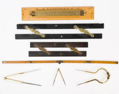
Sold2021Antique & Vintage Marine Map Chart AccessoriesA group of six very good marine map chart accessories, consisting of: two antique ebony & brass parallel rules - the 12" rule stamped THREADWELL LONDON, the 18" rule with minor chips, a 15" antique brSee Sold Price
Sold2023World's highest waterfalls & biggest lakes. HUGHES 1876 old antique map chartTITLE/CONTENT OF MAP: 'Waterfalls. Lakes' DATE PRINTED: 1876 IMAGE SIZE: Approx 25.0 x 30.5cm, 9.75 x 12 inches (Large) TYPE: Antique hand coloured engraved map CONDITION: Good; suitable for framing.See Sold Price
Sold2024World War 2. Planned expansion of Japanese Empire 1959 old vintage map chartCAPTION PRINTED BELOW PICTURE: 'The War with Japan - Contemplated Expansion of Japanese Empire' DATE PRINTED: 1959 IMAGE SIZE: Approx 25.0 x 32.0cm, 9.75 x 12.75 inches (Large) TYPE: Antique colour miSee Sold Price
Sold2023West Indies. Caribbean. The American Mediterranean 1885 old antique map chartTitle: West Indies. Caribbean. The American Mediterranean 1885 old antique map chart Description: West Indies' by Engraved for Élisée Reclus (1885). Antique colour map; Scale 1:12,000,000, 3See Sold Price
Sold2023SOUTH AMERICA Brazil Argentina Chile Bolivia etc 1907 old antique map chartTitle: SOUTH AMERICA Brazil Argentina Chile Bolivia etc 1907 old antique map chart Description: South America' by Unsigned (1907). Colour antique map, 31.0 x 23.5cm, 12.25 x 9.25 inches Product InformSee Sold Price
Sold2018Maps and Map MakersMaps and Map Makers Key reference work Author: Ronald Vere Tooley Illustrations Color B/W Illustrations Size: 4to Binding HarSee Sold Price
Sold2022Cape HornFirst edition. Publishers blue cloth with silver title + vignette. Silver title to spine. Full-page + in-text illustrations. 6 fold-out colour charts and maps. A very nice copy. Publisher: Robert HaleSee Sold Price
Sold2021Baxter Astronomy Antique Prints (4)Isaac Frost (after), set of 4 astronomy planetary motion, celestial sky map charts. George Baxter, London C. 1846. Baxter oil color prints. 10 1/2" x 12 1/2".See Sold Price
Sold2023Baxter Astronomy Antique Prints Set (5)Isaac Frost (after), set of 6 astronomy planetary motion, celestial sky map charts. George Baxter, London c. 1846. Baxter oil color prints. 10" x 12".See Sold Price
Sold2024Baxter Astronomy Antique Prints Set (4)Isaac Frost (after), set of 4 astronomy planetary motion, celestial sky map charts. George Baxter, London c. 1846. Baxter oil color prints. 10" x 12 1/2".See Sold Price
Sold2018Antique Chart of the Island of Tahiti, 1775Title/Content of Map: Chart of the Island of Otaheite Date Printed: 1775 ca. Cartographer: Capt. James Cook R.N. Size (inches): 12.3x16.1 Large scale map of the Island of Tahiti, with detailed typograSee Sold Price
Sold2017Antique Map of the Russian Empire in Europe & Asia 1780Map: The Russian Empire in Europe and Asia Publication Date: 1780 ca. Authors: ANONYMOUS Size: Quarto – 8.60 H x 12.50 W Inches Unusual English illustration map on a polar projection. Browned. ModerSee Sold Price
Sold2022Fort Worth Railroad Map, Cowboy Portrait (2)Fort Worth Railroad map illustration, ink on paper; Cowboy portrait, graphite on paper, sight: 18 x 12", frame: 27 x 21" Provenance: A San Antonio, Texas collection We happily provide seamleSee Sold Price
Sold20211802 Morse's Universal Geography Vol 1-2 Morse, FMorse, Jedidiah. 1801-1802 Morse’s Universal Geography Part I and II. Part I is a Fourth Edition and is corrected and enlarged with 28 illustrated maps and charts. Printed at Boston by Isiah ThomasSee Sold Price
Sold202112 VOLS. HISTORICAL WRITINGS OF JOHN FISKE, 1902The Historical Writings of John Fiske, complete in (12) volumes; Standard Library Edition illustrated with many photogravures, charts, maps, facsimiles, etc.; pub. Houghton Mifflin, 1902. Dimensions:See Sold Price
6 days LeftSwann Auction Galleries(CALIFORNIA.) Edmond Guillemin-Tarayre. Mission Scientifique au Mexique et dans L'Amerique Centrale$900
Jun 29Trillium Antique Prints & Rare BooksFerrari - 12 Engravings of Gardens, Gardening Tools, and Floral Allegorical Scenes$100
5 days LeftNY Elizabeth M. HANSIZ'S 1729 GERMANIA SACRA BLINDSTAMPED PIGSKIN ANTIQUE FOLIO WITH MAP$100
BonhamsANSON, GEORGE, BARON. 1697-1762. A Voyage Round the World, in the Years MDCCXL, I, II, III, IV. ...$800