Sold20201855 Perry Expedition Map of Gales and HurricanesFramed Antique Map, Gales and Hurricanes, from the Perry Expedition of 1855, as traced by William Redfield, including the Sandwich Islands with the track of the Kona winds. With light hand coloring.See Sold Price
Sold2023Perry, Commodore 1856 Pair of Maps. Gales, Hurricanes & Gulf Stream. PacificFolio Lithograph Maps Published 1856, Washington for "Narrative of the Expedition of an American Squadron to the China Seas and Japan, performed in the years 1852, 1853, and 1854" by Commodore MatthewSee Sold Price
Sold20231855 US Naval Astronomy Expedition South America MAPS CHILE Argentina PERU1855 US Naval Astronomy Expedition South America MAPS CHILE Argentina PERU James Melville Gilliss was an astronomer, officer in the US Navy and founder of the United States Naval Observatory. US NavalSee Sold Price
Sold20221855 US Naval Astronomical Expedition Southern1855 US Naval Astronomical Expedition Southern Hemisphere INDIANS Maps James Melville Gilliss was an astronomer, officer in the US Navy and founder of the United States Naval Observatory. US Naval AstSee Sold Price
Sold20211855 1ed Voyages in India Japan & CHINA Commodore Perry1855 1ed Voyages in India Japan & CHINA Commodore Perry Expedition Bayard Taylor Bayard Taylor was a 19th-century travel writer whose abundant notes and reports have been referenced for decades sinceSee Sold Price
Sold2023Harper's New Monthly Magazine Vol. XII (12)Harper's New Monthly Magazine Vol. XII December 1855 - May 1856. Includes "Gold Fields of Central America," "Nightly Scene in London" by Charles Dickens, "Commodore Perry's ExpediSee Sold Price
Sold2023Antique Hand Colored Fish Print from Perry's Japan Expedition c.1855Antique (c.1855) Hand Colored Engraved Aquatint from Commodore Perry's Japan Expedition. "From Narrative of the Expedition of an American Squadron to the China Seas and Japan, Performed in the Years 1See Sold Price
Sold2017Perry 1855 Exploration Book"Narrative of The Expedition of An American Squadron to the China Seas and Japan, performed in the years 1852, 1853 and 1854 under the command of Commodore M.C. Perry, United States Navy by order of tSee Sold Price
Sold20201855 Johnston Chart of Air Currents, Trade Winds andTitle/Content of Map: 1855 Johnston Chart of Air Currents, Trade Winds and Hurricanes -- Geographical Distribution of the Currents of Air or the Perennial Periodical and Variable Winds , Showing alsoSee Sold Price
Sold20201856 1ed Narrative of Expedition American Squadron1856 1ed Narrative of Expedition American Squadron Perry Hawks JAPAN China MAPS Matthew C Perry was one of the most important American Naval officers during the 19th-century. While he was notable forSee Sold Price
Sold20211855 Plan of Santiago Chile and AnotherLithograph plan of the city of Santiaho in Chile, printed at Washington DC, 1855 based on an expedition by Lieut. J.M. Gilliss. This accompanied by a Map of the province from the same report. Both FinSee Sold Price
Sold2023Perry, Matthew 1856 Large Map. Chart of the World. Track of the U.S Steam Ships"Chart of the World showing the Track of the U. S. Steam Frigates Mississippi, Susquehanna, and Powhatan" Large Folio Lithograph Map Published 1856, Washington for "Narrative of the Expedition of an ASee Sold Price
Sold20211855 Three Map Set Republic of ChileThree folding maps of the Republic of Chile from surveys of Pissis and Allan Campbell and the maps of Claude Gay, published by the US Government Expedition headed by Lt. J M Gilliss, Washington 1855.See Sold Price
Sold2023Perry, Commodore 1856 Large Map. China, Japan & Philippines"Chart of the coast of China and of the Japan Islands including the Marianes and a part of the Philippines" Large Folio Lithograph Map Published 1856, Washington for "Narrative of the Expedition of anSee Sold Price
Sold2024Perry, Matthew C. 1856 Large Map. Shah Bay, Lew Chew I. JapanLarge Folio Lithograph Map Published 1856, Washington for "Narrative of the Expedition of an American Squadron to the China Seas and Japan, performed in the years 1852, 1853, and 1854" by Commodore MaSee Sold Price
Sold2024Perry, Matthew C. 1856 Large Map. Harbor of Hakodadi I, Yesso Id. JapanLarge Folio Lithograph Map Published 1856, Washington for "Narrative of the Expedition of an American Squadron to the China Seas and Japan, performed in the years 1852, 1853, and 1854" by Commodore MaSee Sold Price
Sold2023Perry, Matthew C. 1856 Large Map. The Coffin Islands, JapanLarge Folio Lithograph Map Published 1856, Washington for "Narrative of the Expedition of an American Squadron to the China Seas and Japan, performed in the years 1852, 1853, and 1854" by Commodore MaSee Sold Price
Sold2023Perry, Commodore 1856 Large Map. Bay of Yedo, Tokyo, Japan"Western Shore of the Bay of Yedo" Large Folio Lithograph Map Published 1856, Washington for "Narrative of the Expedition of an American Squadron to the China Seas and Japan, performed in the years 18See Sold Price
Sold2022(JAPAN -- PERRY.) Matthew Calbraith Perry; and Francis L. Hawks Narrative of the Expedition of an(JAPAN -- PERRY.) Matthew Calbraith Perry; and Francis L. Hawks Narrative of the Expedition of an American Squadron to the China Seas and Japan, Performed in the Years 1852, 1853, and 1854. 22 maps anSee Sold Price
Sold20211855 VOYAGES 1st ed RUSSIA on the Black Sea Seymour1855 VOYAGES 1st ed RUSSIA on the Black Sea Seymour Exploration Sea of Azof MAP Henry D. Seymour was a British politician who is much better known for his journeys and expeditions in the Middle East.See Sold Price
Sold2022Rare 1836 Col. Dodge Expedition map - 1st printing, SteenLarge and important early copper engraved map of the western U. S. showing the route of Col. Henry Dodge’s 1835 Expedition from Fort Leavenworth to the Rocky Mountains. Rare first printing withSee Sold Price
Sold20181842-44 Fremont Expedition Map of Rockies, OR and CA --Title/Content of Map: 1842-44 Fremont Expedition Map of Rockies, OR and CA -- Report of the Exploring Expedition to the Rocky Mountains in the Year 1842, and to Oregon and North California in the YearSee Sold Price
Sold2024Original Antique Ortelius 1595 Alexandri Magni Macedonis Expedition Map of Alexander's ExpeditionsWell framed as shown. Antique hand-colored map showing Alexander of Macedonia's expeditions by Abraham Ortelius. Framed, matted, and sealed. Unexamined out of frame. Approx. sight size 15 3/8" x 19 3/See Sold Price
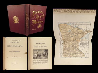
Sold20241887 History of Minnesota Dakota INDIANS Little Crow Lewis Cass Expedition MAP1887 History of Minnesota Dakota INDIANS Little Crow Lewis Cass Expedition MAP Thomas Kirks “History of Minnesota” is a rare, illustrated survey of the earliest days of Minnesota, early inhabiSee Sold Price
Featured12 hrs LeftJasper521855 Colton Map of Turkey in Asia / Middle East -- Turkey in Asia and the Caucasian Provinces of$35
12 hrs LeftJasper521934 Annand Map of Antarctica And Second Byrd Expedition -- Authorized Map of the Second Byrd$110
1 day LeftJasper52London in 1897 with street improvements since 1855. 80x105 cm. Edwards 1898 map$260
11 hrs LeftChampagne AuctionsKent Kane, Elisha - Arctic Exploration, The second Grinnell Expedition, 1st edition - 1856CA$120(1 bid)
2 days LeftSwann Auction GalleriesVARIOUS PHOTOGRAPHERS A vast photographic archive of circa 142 photographs documenting activity at$6,000


![[MAPS] 1855 Antique Map of Paris (1 of 3)](https://p1.liveauctioneers.com/7226/343679/186655055_1_x.jpg?height=282&quality=70&version=1726238840)


![[MAPS] MISC CANADA/AMERICA. LOT OF 6 (1 of 6)](https://p1.liveauctioneers.com/8124/343618/186530170_1_x.jpg?height=282&quality=70&version=1726178725)


