Sold2022Homann. Amplissimae Regionis Mississipi. c1720.[Map/America] Homann, Johannes Baptist. Amplissimae Regionis Mississipi. Nuremberg, c.1720. Hand colored copper-engraved map. Homann's important and widely disseminated map of the southeast of North ASee Sold Price
Sold2021Johann Baptiste Homann MapJohann Baptiste Homann "Amplissimae regionis Mississipi seu Provinciae Ludovicianae...", Nuremberg, 1720, hand-colored map, 19 1/2 in. x 22 5/8 in., framed, together with antique hand-colored map of LSee Sold Price
Sold2022Homann - Map of North America, Louisiana ProvinceJohann Baptist Homann (German, 1664-1724), Amplissimae Regionis Mississipi Seu Provinciae Ludovicianae A R.P. Ludovico Hennepin Francisc Miss In America Septentrionali Anno 1687..., Nuremberg, circa 1See Sold Price
Sold2018MAPS: Homann 1720 Regionis MississipiMAPS: Homann 1720 Regionis Mississipi, Amplissimae Regionis Mississipi Seu Provinciae Ludovicianae a R.P. Ludovico Hennepin Francisc Miss In America Septentrionali Anno 1687... a Jo. Bapt. Homanno S.CSee Sold Price
Sold2019Johann Baptist Homann (1661-1774), "Amplissima RegionisJohann Baptist Homann (1661-1774), "Amplissima Regionis Mississipi seu Provinciae Ludoviciae a R.P. Ludovico Hennepin, Francise Miss. In America Septentrionale," 1687, hand colored, H.- 19 in., W.- 23See Sold Price
Sold2019Johann Baptist Homann (1661-1774), "Amplissima RegionisJohann Baptist Homann (1661-1774), "Amplissima Regionis Mississipi seu Provinciae Ludoviciae a R.P. Ludovico Hennepin, Francise Miss. In America Septentrionale," 1687, hand colored, H. - 19 in., W. -See Sold Price
Sold2021Asia Minor - Turkey 1762 by Homann HeirsTitle: Asia Minor - Turkey 1762 by Homann Heirs Date/Period: 1762 Materials: Copperplate engraved Size: 24 x 20 1/2" Turkey and the Black Sea region is the main focus, with parts of Greece and her islSee Sold Price
Sold2022Homann Atlas Compeniarius, 1748HOMANN, Johann Baptist (1663-1724). Atlas Compeniarius quinquaginta selectarum tabularum geographicarum Homanni. Nuremberg: Heirs of J.B. Homann, 1748 [maps dated 1741-1749]. Folio (21 x 12 inches). ESee Sold Price
Sold2021Course of the River Mississipi [sic]"Course of the River Mississipi [sic], from the Balise to Fort Chartres..." map by Lieutenant John Ross of the 34th Regiment, engraved and published with hand-colored outlines by Robert Sayer and JohnSee Sold Price
Sold2022China.- Ortelius (Abraham) Chinae, olim Sinarum regionis, nova descriptio, 1584 [but slightlyChina.- Ortelius (Abraham) Chinae, olim Sinarum regionis, nova descriptio, detailed map centred on China and based on the work of Jorge de Barbuda, a Portuguese Jesuit also known as Ludovicus GeorgiusSee Sold Price
Sold2022ORTELIUS, ABRAHAM. 1527-1598. Chinae olim Sinarum regionis. Antwerp: 1584 (but c.1592).ORTELIUS, ABRAHAM. 1527-1598. Chinae olim Sinarum regionis. Antwerp: 1584 (but c.1592). Engraved map with hand-coloring. 407 x 553 mm, on one folio leaf, folded at center, extracted from atlas, with tSee Sold Price
Sold2022(MISSISSIPPI RIVER.) John Ross. Course of the River Mississipi, From the Balise to Fort Chartres.(MISSISSIPPI RIVER.) John Ross. Course of the River Mississipi, From the Balise to Fort Chartres. Engraved folding map of the lower Mississippi River on two sheets joined. 44¾x15 inches sheet sizSee Sold Price
Sold2018Homann: Antique Map of New England, 1720The map names New England as "Almouchi Cosen" as well as Nova Anglia, while present-day New York State is named variously as New Jork, Nieuw Nederland and Novum Belgium (New York, New Netherlands andSee Sold Price
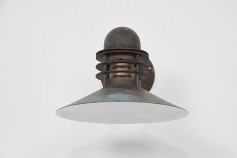
Sold2021Alfred Homann & Ole V. Kjaer, 'Nyhavn' Outdoor SconceAlfred Homann & Ole V. Kjaer 'Nyhavn' outdoor sconce, ca. 1976 Patinated copper, painted copper. Manufactured by Louis Poulsen, Denmark. Mount plate with manufacturer's labels. Dimensions: 9" H 12.25"See Sold Price
Sold2015Alfred Homann and Ole Kjaer Nyhavn sconces, pairAlfred Homann and Ole Kjaer Nyhavn sconces, pair Louis Poulsen Denmark, 1976 copper, glass 12 w x 17 d x 9 h inches Signed with applied manufacturer's label to each example: [Louis Poulsen Made in DenSee Sold Price
Sold20221746 MAP OF THE WESTERN HEMISPHERE By HomannHistoric Maps 1746 MAP of the WESTERN HEMISPHERE by Homann with Cartouche at lower left depicts Native American Indians 1746-Dated, Hand-Colored Engraved MAP OF THE WESTERN HEMISPHERE titled, "AmericaSee Sold Price
Sold2023[MAPS]. HOMANN, Johann Baptist (1663-1724). Four engraved continent maps with hand-coloring, each[MAPS]. HOMANN, Johann Baptist (1663-1724). Four engraved continent maps with hand-coloring, each matted and framed, comprising: Totius Americae… Nuremberg, [ca 1720]. Overall sheet 508 x 590 mmSee Sold Price
Sold2024Homann Map of New Spain 1720HOMANN, Johann Baptista (1664-1724). Regni Mexicani seu Novae Hispaniae. Engraved map. Nuremberg, 1720. 20" x 23 1/2" sheet. This superb map covers the region from the Great Lakes and Nova Scotia throSee Sold Price
Sold2020Homann World Map*** START PRICE IS THE RESERVE *** [World] HOMANN, Heirs (18th century). Planiglobii Terrestris Mappa Universalis utrumque. Engraved map with original hand color in part. Nuremberg: Homann Heirs, 1746See Sold Price
Sold2023[MAP] HOMANN. VIRGINIA MARYLANDIA CAROLINA (1715)Homann, Johann Baptist. VIRGINIA MARYLANDIA ET CAROLINA IN AMERICA SEPTENTRIONALI BRITANNORUM INDUSTRIA. Nuremberg: circa 1715. Handcolour outline, featuring pictorial cartouche illustrating scene witSee Sold Price
Sold2016Rare 1710 Johann Homann Color Celestial MapNuremberg; 1710. Johann Homann colored engraved celestial Hemispherium Coeli Boreale map printed on woven paper. It is displayed in eglomized glass and wood frame. Dimensions Map: 23" by 19" (58.4 cmSee Sold Price
Sold2016HOMANN: Virginia Marylandia et Carolina, 1730-60[Homann/Virginia/Maryland/Carolinas] VIRGINIA MARYLANDIA ET CAROLINA IN AMERICA SEPTENTRIONALI BRITANNORUM INDUSTRIA EXCULTAE. [Johann Baptiste Homann, ca. 1730-1760. First engraved c. 1714. This is aSee Sold Price
Sold2022[MAP]. HOMANN, Johann Baptist (1663-1724). Virginia, Marylandia et Carolina in America[MAP]. HOMANN, Johann Baptist (1663-1724). Virginia, Marylandia et Carolina in America Septentrionali. Nuremberg, [ca 1714].   Engraved map of the Mid-Atlantic with hand-coloring in wash and outlSee Sold Price
Sold20171746 Homann World MapTitle: 1746 Homann World Map -- Planiglobii Terrestris Mappa Universalis utrumque Hemisphaerium Orient et Occidentale Repraesentans ex IV. Mappis Generalibus ... / Mappe-Monde qui Represente les DeuxSee Sold Price
May 05Tremont Auctions18th century map "Americae Septentrion" by Homann. Rarer early edition. Framed. Holes around outer$250(1 bid)
18 hrs LeftJeschke Jadi Auctions Berlin GmbHHomann (Hg.), Georg Gotthilf Jacob Flora von Pommern, oder Beschreibung der in Vor- und€200
Featured4 days LeftJasper52RARE MAP, 1762, 15 Cities of the Safavid era Persian Empire by J. B. Homann$600
18 hrs LeftJeschke Jadi Auctions Berlin GmbHHomann, Johann Baptist 2 teilkolorierte Kupferstichkarten. Um 1730. Je (in Punkten) unter€200
May 10Hermann Historica GmbHA Homann-Webau Eight-Wheel Panzer Reconnaissance Car 744, camouflage finish€400
4 days LeftJasper521736 LARGE MAP OF SILESIA POLAND SAGANENSIS antique 25 x 4 3/4" Duchy of Krnov$260
18 hrs LeftJeschke Jadi Auctions Berlin GmbHSammlung von zwei altkolorierten Kupferstichkarten. 18. Jh. Maße je ca. 53 x 65 cm.€200
4 days LeftJasper521720 antique MAP of LOWER SAXONY GERMANY 18th CENT. Circulus Saxoniae inferioris$75
18 hrs LeftJeschke Jadi Auctions Berlin GmbHProspectus Norimbergensis. Teilkol. Kupferstich mit 16 Ansichten in zwei Teilen. Nünberg,€300


![Homann. Amplissimae Regionis Mississipi. c1720.: [Map/America] Homann, Johannes Baptist. Amplissimae Regionis Mississipi. Nuremberg, c.1720. Hand colored copper-engraved map. Homann's important and widely disseminated map of the southeast of North A](https://p1.liveauctioneers.com/179/268856/140616121_1_x.jpg?height=310&quality=70&version=1668545725)


![Homann Atlas Compeniarius, 1748: HOMANN, Johann Baptist (1663-1724). Atlas Compeniarius quinquaginta selectarum tabularum geographicarum Homanni. Nuremberg: Heirs of J.B. Homann, 1748 [maps dated 1741-1749]. Folio (21 x 12 inches). E](https://p1.liveauctioneers.com/1968/250616/130196470_1_x.jpg?height=310&quality=70&version=1654190895)
![Course of the River Mississipi [sic]: "Course of the River Mississipi [sic], from the Balise to Fort Chartres..." map by Lieutenant John Ross of the 34th Regiment, engraved and published with hand-colored outlines by Robert Sayer and John](https://p1.liveauctioneers.com/1007/196938/99435775_1_x.jpg?height=310&quality=70&version=1615322535)


![[MAPS]. HOMANN, Johann Baptist (1663-1724). Four engraved continent maps with hand-coloring, each: [MAPS]. HOMANN, Johann Baptist (1663-1724). Four engraved continent maps with hand-coloring, each matted and framed, comprising: Totius Americae… Nuremberg, [ca 1720]. Overall sheet 508 x 590 mm](https://p1.liveauctioneers.com/197/284572/150193668_1_x.jpg?height=310&quality=70&version=1680880467)

![Homann World Map: *** START PRICE IS THE RESERVE *** [World] HOMANN, Heirs (18th century). Planiglobii Terrestris Mappa Universalis utrumque. Engraved map with original hand color in part. Nuremberg: Homann Heirs, 1746](https://p1.liveauctioneers.com/1968/163248/82424684_1_x.jpg?height=310&quality=70&version=1583340284)
![[MAP] HOMANN. VIRGINIA MARYLANDIA CAROLINA (1715): Homann, Johann Baptist. VIRGINIA MARYLANDIA ET CAROLINA IN AMERICA SEPTENTRIONALI BRITANNORUM INDUSTRIA. Nuremberg: circa 1715. Handcolour outline, featuring pictorial cartouche illustrating scene wit](https://p1.liveauctioneers.com/8124/310027/165853625_1_x.jpg?height=310&quality=70&version=1700184289)

![HOMANN: Virginia Marylandia et Carolina, 1730-60: [Homann/Virginia/Maryland/Carolinas] VIRGINIA MARYLANDIA ET CAROLINA IN AMERICA SEPTENTRIONALI BRITANNORUM INDUSTRIA EXCULTAE. [Johann Baptiste Homann, ca. 1730-1760. First engraved c. 1714. This is a](https://p1.liveauctioneers.com/179/93063/47518611_1_x.jpg?height=310&quality=70&version=1473189014)
![[MAP]. HOMANN, Johann Baptist (1663-1724). Virginia, Marylandia et Carolina in America: [MAP]. HOMANN, Johann Baptist (1663-1724). Virginia, Marylandia et Carolina in America Septentrionali. Nuremberg, [ca 1714].   Engraved map of the Mid-Atlantic with hand-coloring in wash and outl](https://p1.liveauctioneers.com/197/243556/126318973_1_x.jpg?height=310&quality=70&version=1649293172)


