Sold2022(MISSISSIPPI RIVER.) John Ross. Course of the River Mississipi, From the Balise to Fort Chartres.(MISSISSIPPI RIVER.) John Ross. Course of the River Mississipi, From the Balise to Fort Chartres. Engraved folding map of the lower Mississippi River on two sheets joined. 44¾x15 inches sheet sizSee Sold Price
Sold2023ROSS, JOHN Course of the River Mississippi, from the Balise to Fort Chartres; Taken on an ExpeditionROSS, JOHN Course of the River Mississippi, from the Balise to Fort Chartres; Taken on an Expedition to the Illinois, in the Latter End of the Year. London: Robert Sayer, June 1775. Second issue (follSee Sold Price
Sold2023After Lieutenant John Ross (British, 1744-1809), "Course of the River Mississippi [sic], from theAfter Lieutenant John Ross (British, 1744-1809), "Course of the River Mississippi [sic], from the Balise to Fort Chartres...," 1775, engraved and published with hand-colored outlines by Robert Sayer aSee Sold Price
Sold2021Course of the River Mississipi [sic]"Course of the River Mississipi [sic], from the Balise to Fort Chartres..." map by Lieutenant John Ross of the 34th Regiment, engraved and published with hand-colored outlines by Robert Sayer and JohnSee Sold Price
Sold2016Thomas Jefferys (1719-1771), "Course of the RiverThomas Jefferys (1719-1771), "Course of the River Mississippi from the Balise to Fort Chartres," 20th c., after the 1775 original, presented in a silver gilt frame, H.- 48 3/8 in., W.- 21 7/8 in.See Sold Price
Sold2024John Senex Map of Louisiana & Mississippi RiverJohn Senex A Map of Louisiana and the River Mississipi [sic], London, 1721, engraving with hand coloring; English translation after Guillaume Delisle's 1718 map. Lower right reads "This map of the MisSee Sold Price
Sold2023John Eberhardt "Drawing a Pair" PrintJohn is a self taught artist and sportsman from the Mississippi River Valley. John was born in Moline, Illinois. Lucky enough to be raised in a sporting environment, he has hunted and fished all his lSee Sold Price
Sold2018Two Framed Prints of Civil War Battles Fort Pillow and8.5 X 10.5 AND 9.5 X 11.5Two Framed Prints. Island Number Ten April 7, 2862 shows Confederate control of the Mississippi River island. Fort Pillow Massacre, April 12, 1864 shows Union forces includingSee Sold Price
Sold2017"Forcing the Passage of the Mississippi River,"Forcing the Passage of the Mississippi River, Bombardment of Forts Jackson and St. Philip, and Destruction of the Rebel Flotilla of Iron-plate vessels, by the National Squadron under Com. Farragut ApSee Sold Price
Sold2022John Senex Map of Louisiana & Mississippi River 1721John Senex (English, 1678-1740). "Map of Louisiana and the River Mississippi," from "A New General Atlas," London, 1721. Dedicated to William Law of Lanreston. This map is an EngliSee Sold Price
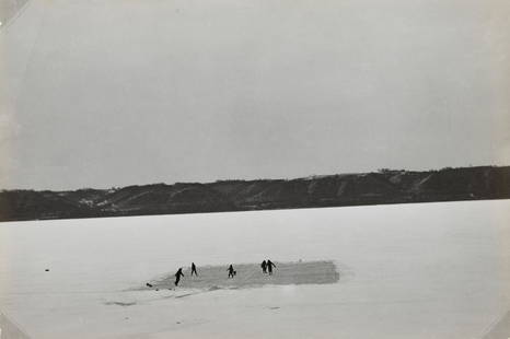
Sold2021JOHN VACHON - Skating on the Mississippi River nearTHIS LOT IS TO BE SOLD WITH NO RESERVE. Property from a distinguished Private Collection, New York ARTIST: John Vachon TITLE: Skating on the Mississippi River near Lake City, Minnesota, 1942 MEDIUM: FSee Sold Price
Sold20221764 Bellin Map of Mississippi and Red Rivers in Louisiana -- Suite du Cours du Fleuve St. LouisTitle: 1764 Bellin Map of Mississippi and Red Rivers in Louisiana -- Suite du Cours du Fleuve St. Louis depuis la Riviere d'Iberville jusqua Celle des Yasous Cartographer: J Bellin Year / Place: 1764,See Sold Price
Sold2021Large Albumen of Fort Pickering, TennesseeUn-mounted albumen measuring approximately 10 x 13.5inch. Shows the interior of the fort down from Mississippi River. There are some tears noted on the edges and is light in the contrast. There is a pSee Sold Price
Sold2023Robert Mouat (1920-2007), "Mark Twain Remembrance" Mixed media including painted wood, paper,Robert Mouat(1920-2007)"Mark Twain Remembrance"Mixed media including painted wood, paper, and string set in a wood and plate glass caseTitled, attributed, and marked to plaque: Mississippi River steamSee Sold Price
Sold202212 VOLs RAILROAD ROUTES TO THE PACIFIC OCEAN 1855Volumes I- X. Illustrated Reports of Explorations and Surveys to Ascertain the Most Practicable and Economical Route for a Railroad from the Mississippi River to the Pacific Ocean. Made under the direSee Sold Price
Sold2017C.1721 MAP OF LOUISIANA AND MISSISSIPPI RIVERBy John Senex. Dimensions: (Frame) H 24" x W 27.5" (Sight) H 19.75" x W 23" Condition: Creases to paper from previous folds and discoloration and stains to the center of the paper. Wear to gilt frame.See Sold Price
Sold2022David Kaskowitz, St. Louis (1925 -), Mississippi River Scene, Eads Bridge, watercolor on paperDavid KaskowitzSt. Louis, (1925 - )Mississippi River Scene, Eads Bridgewatercolor on paperinitialed lower right, framed.David Kaskowitz was a classmate and lifelong friend of John Wehmer.13 x 17See Sold Price
Sold20221862 John Pope Civil War Map Missouri BowenMap showing the System of Rebel Fortifications on the Mississippi River at Island No. 10 and New Madrid also The Operations of the U.S. Forces under General John Pope Against These Positions. "Bowen &See Sold Price
Sold2019Cassin, John 1860 Group of 3 Hand Col USA Bird PrintsHand Coloured Lithographs Published 1855-60, Washington for "Reports of Explorations and Surveys, To Ascertain the Most Practicable and Economical Route for a Railroad from the Mississippi River To ThSee Sold Price
Sold2023John Williams Taylor Maryland Artist Etching WPA Era SIgnedJohn Williams Taylor Maryland Artist Etching WPA Era Signed, 1937, "Trempealeau Dam", Upper Mississippi River in Wisconsin, 8 x 11" image size, 11 x 14 1/2" overall.John Williams Taylor studied with JSee Sold Price
Sold2022Frederick D. Ogden, oil, Hay Harvest,on canvas, well listed artist, image area 24" X 36" plus carved and gilt frame.....Born in Hancock County on the Mississippi River in Illinois in 1892. Is a direct descendant of John Ogden the PilgrimSee Sold Price
Sold2023Western Union Telegraph Company Pass [155809]Pass no. M704, issued to John Galloway, Memphis & Charleston RR, to transit messages between all points east of the Mississippi River including St. Louis and State of Texas. Preprinted signature of prSee Sold Price
Sold2018Civil War on the Western Border 1854-1865 Jay MonaghanThe first phase of the Civil War was fought west of the Mississippi River at least six years before the attack on Fort Sumter. Starting with the passage of the Kansas-Nebraska Act in 1854, Jay MonaghaSee Sold Price
Sold2023LARGE SAM NEWTON HIGHWAYMEN ST. JOHN'S RIVER PAINTINGNEWTON, Sam, (American, b. 1948): Highwaymen St. John's River Scene with Herons or Egrets, Oil/Upson Board, 24" x 36", signed lower left, original frame, 28.5" x 40.5".See Sold Price
May 09Hunt and Peck Estate Services, Inc.John Cary Map Of The Principal Roman Camps, Forts, Walls & C. England/Scotland$50
May 09Freeman's | HindmanOscar E. Berninghaus (American, 1874-1952) Mississippi River Woods, St. Louis, Missouri$3,000
May 18Rich Penn AuctionsAndrew Clemens Sand Art. Clemens is credited with "inventing" this rare art form of building$200(3 bids)
May 12Schilb Antiquarian Rare Books1883 America Illustrated Yellowstone Erie Canal Saratoga Springs Niagara Falls$14(2 bids)
May 16DuMouchellesMediterranean Revival Style Terra Cotta Medallion Ca. 1925, "Grand Riviera Theater, Detroit, MI", H$2,500
May 19Heartland Artifact Auctions IncWonderful Colorado Gem Arrowhead, High Plains. Found by Anthony Wood Family in Morgan County$12(2 bids)
May 19Heartland Artifact Auctions IncWonderful Colorado Gem Arrowhead, High Plains. Found by Anthony Wood Family in Morgan County$10(1 bid)
May 19Heartland Artifact Auctions IncWonderful Colorado Gem Arrowhead, High Plains. Found by Anthony Wood Family in Morgan County$10
May 19Heartland Artifact Auctions IncWonderful Colorado Gem Arrowhead, High Plains. Found by Anthony Wood Family in Morgan County$10(1 bid)
May 19Heartland Artifact Auctions IncWonderful Colorado Gem Arrowhead, High Plains. Found by Anthony Wood Family in Morgan County$10


![After Lieutenant John Ross (British, 1744-1809), "Course of the River Mississippi [sic], from the: After Lieutenant John Ross (British, 1744-1809), "Course of the River Mississippi [sic], from the Balise to Fort Chartres...," 1775, engraved and published with hand-colored outlines by Robert Sayer a](https://p1.liveauctioneers.com/328/305751/163451640_1_x.jpg?height=310&quality=70&version=1697494776)
![Course of the River Mississipi [sic]: "Course of the River Mississipi [sic], from the Balise to Fort Chartres..." map by Lieutenant John Ross of the 34th Regiment, engraved and published with hand-colored outlines by Robert Sayer and John](https://p1.liveauctioneers.com/1007/196938/99435775_1_x.jpg?height=310&quality=70&version=1615322535)

![John Senex Map of Louisiana & Mississippi River: John Senex A Map of Louisiana and the River Mississipi [sic], London, 1721, engraving with hand coloring; English translation after Guillaume Delisle's 1718 map. Lower right reads "This map of the Mis](https://p1.liveauctioneers.com/7691/320359/172153416_1_x.jpg?height=310&quality=70&version=1708543789)


![Western Union Telegraph Company Pass [155809]: Pass no. M704, issued to John Galloway, Memphis & Charleston RR, to transit messages between all points east of the Mississippi River including St. Louis and State of Texas. Preprinted signature of pr](https://p1.liveauctioneers.com/2699/274463/144089027_1_x.jpg?height=310&quality=70&version=1672966071)


![[CIVIL WAR] Mississippi River Sketch (1 of 2)](https://p1.liveauctioneers.com/7226/325455/175168988_1_x.jpg?height=282&quality=70&version=1712370394)
![Mississippi River. Sheet No.2 [Columbus, Ky. to Island No.9] (1 of 12)](https://p1.liveauctioneers.com/5584/326512/175785588_1_x.jpg?height=282&quality=70&version=1713903186)
![Mississippi River. Sheet No.14 [Island No.80 to Lake Lee] (1 of 6)](https://p1.liveauctioneers.com/5584/326512/175785601_1_x.jpg?height=282&quality=70&version=1713903186)