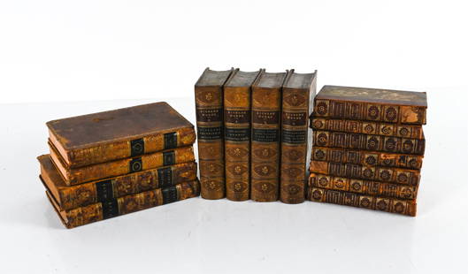
Sold2022GROUPING OF ANTIQUE LEATHER-BOUND BOOKSIncluding (7) vol. "Epochs of History" 1899, with fold-out maps of Europe; (4) vol. Dickens' Works, 1869, plus some miscellaneous volumes. Dimensions: (Overall linear) H 8.75" x W 19" Condition: As isSee Sold Price
Sold2024EUROPE POLITICAL. Austria-Hungary. United Sweden & Norway. JOHNSTON 1899 mapTITLE/CONTENT OF MAP: 'Europe, political' DATE PRINTED: 1899 IMAGE SIZE: Approx 27.0 x 21.0cm, 10.5 x 8.25 inches (Medium) TYPE: Colour antique map CONDITION: Good; suitable for framing. The image shoSee Sold Price
Sold2020AN ANTIQUE MAP, "Europe (Evrop)," JOHN SPEED,AN ANTIQUE MAP, "Europe (Evrop)," JOHN SPEED, CARTOGRAPHER, 1626-1676, hand-colored engraving on paper, Abraham Goos (1589-1643), engraver, published for merchants Thomas Basset and Richard Chiswell iSee Sold Price
Sold20231850s Dufour ATLAS 42 HUGE MAPS Europe ENORMOUS & RARE Geography Cartography1850s Dufour ATLAS 42 HUGE MAPS Europe ENORMOUS & RARE Geography Cartography Adolphe Dufour was a 19th-century French cartographer and map maker known for his highly detailed maps of European cities aSee Sold Price
Sold20212) STIELER & MITCHELL MAPS EUROPE, TURKEY & GREECE(lot of 2) Framed maps, including: (1) engraving with hand coloring on paper, German map of Europe, Turkey, Greece, and the Ionian Islands, from "Stielers Schul-Atlas," published by Justus Perthes, GoSee Sold Price
Sold2021de Fer, Nicolas 1717 Antique Map. Europe"L'Europe Suivant les Nouvelles Observations" Copper Engraved Map Published 1717, Paris for "Introduction a la Geographie" by Nicolas de Fer. Folds as issued. Paper Size: 14 x 10 inch (36 x 25cm) GoodSee Sold Price
Sold2023CYPRUS HONG KONG TOKYO PEKING JERUSALEM. City plans. Anzhu islands 1899 mapCyprus, Hong Kong, Wrangel and Anjou Island, environs of Tokio, Pekin, and Jerusalem' by W. & A.K. Johnston (1899). Colour antique map, 27.0 x 21.0cm, 10.5 x 8.25 inches Details: TITLE/CONTENT OF MAP:See Sold Price
Sold2024Antique Map - Europe - Italy With the Islands of Sicily, Corsica and SardiniaMap of iItaly with the islands of Sicily, Sardinia and Corsica by Francois Halma, 1700. Decorative large map of Italy, with an elaborate cartouche.See Sold Price
Sold20201899 Map of Empires of China, Japan and KoreaAuthor: Miller Title: 1899 Map of Empires of China, Japan and Korea Medium: Ink on Paper Dimensions: 16"X11" Description: Map of the empires of China, Japan and Korea dated 1899. Published by J. MartiSee Sold Price
Sold20211899 Map of LousianaAuthor: Matthews Title: 1899 Map of Lousiana Medium: Ink on Paper Dimensions: 13.5"X11" Map of Louisiana dated 1899. Published by the Matthews Northrup Co. in Buffalo. With extensive dated population,See Sold Price
Sold20201899 Map of British AmericaAuthor: Miller Title: 1899 Map of British America Medium: Ink on Paper Dimensions: 22.5"X16.5" Description: Map of British America, modern day Canada dated 1899. Published by J. Martin Miller and CompSee Sold Price
Sold20211899 Map of PalestineAuthor: Miller Title: 1899 Map of Palestine Medium: Ink on Paper Dimensions: 16.5"X22.5" Map of Palestine dated 1899. Printed and published by J.J. Miller in Chicago. Dated. Key upper left. Double folSee Sold Price
Sold20201899 Map of the Empires of China, Japan and KoreaAuthor: Miller Title: 1899 Map of the Empires of China, Japan and Korea Medium: Ink on Paper Dimensions: 16.5"X11" Map of the empires of China, Japan and Korea dated 1899. Published by J. Martin MilleSee Sold Price
Sold20201899 Map of OceaniaAuthor: Miller Title: 1899 Map of Oceania Medium: Ink on Paper Dimensions: 16.5"X11.5" Map of Oceania dated 1899. Published by J. Martin Miller and Company in Chicago. Very detailed full folio map. CaSee Sold Price
Sold20201899 Map of the North PoleAuthor: Miller Title: 1899 Map of the North Pole Medium: Ink on Paper Dimensions: 16"X11" Description: Map of the empires of the North Pole dated 1899. Published by J. Martin Miller and Company in ChiSee Sold Price
Sold20211969 East German Interflug Route Map -- Europe AfricaTitle: 1969 East German Interflug Route Map -- Europe Africa Middle East Cartographer: Interflug Year / Place: 1969 Map Dimension (in.): 31.4 X 23.2 in. unfolded This folding route map of the East GerSee Sold Price
Sold2021Tallis, John (Pub) 1852 Map. EuropeSteel Engraved Map with Original Outline Hand Color Published 1852-56 by John Tallis, London for "The Universal Pronouncing Dictionary" by Thomas Wright. Drawn & Engraved by John Rapkin. Centre fold aSee Sold Price
Sold2023Lizars, Daniel 1831 LG Rare HC Map. Europe on 2 SheetsLarge Folio Copper Engraved Map Published 1831-2 by John Hamilton, Successor to Daniel Lizars, Edinburgh for "The Edinburgh Geographical and Historical Atlas..." First Edition by Daniel Lizars. Very fSee Sold Price
Sold20211899 Map of HawaiiTitle: 1899 Map of Hawaii Author: Miller Medium: Ink on Paper Dimensions: 16.5"X11" Description: Map of Hawaii dated 1898. Printed and published by J Martin Miller in Chicago. Key middle left. Inset oSee Sold Price
Sold2019Thomas Kitchin Map [Europe]Thomas Kitchin (cartographer) color map of 'Europe Drawn from the best Authorities by T. Kitchin'. Published London, mid-18th century. In G/G+-VG condition, with foxing and spotting in margins. Two foSee Sold Price
Sold20232 50 x 38 Color Print Maps, Europe & South AmericaLot of 2 color print maps. Both in packaging that reads Giant color print maps of, size 50 x 38. New. Informative, practical. One full color map of Europe and 1 full color map of South America. EuropeSee Sold Price
Sold20211899 Map of ItalyAuthor: Cram Title: 1899 Map of Italy Medium: Ink on Paper Dimensions: 14.5"X21.5" Map of Italy and San Marino dated 1899. Printed and published by George Cram in Chicago. Part of his Family Atlas. DoSee Sold Price
Sold20201899 Map of Porto RicoTitle: 1899 Map of Porto Rico Medium: Ink on Paper Dimensions: 16.5"X11" Map of Porto Rico dated 1889. Map key located lower left. Inset of the Viequis Islands lower left. Color coded for territorialSee Sold Price
Sold20201899 Map of the Pacific Ocean and AustraliaAuthor: Miller Title: 1899 Map of the Pacific Ocean and Australia Medium: Ink on Paper Dimensions: 16"X11" Map of the Pacific Ocean and Australia dated 1899. Published by J. Martin Miller and CompanySee Sold Price
Jun 30Global Auctions CompanyHand Colored Engraved Map of Europe, Jean Baptiste Bourguignon Anville 1754$450
5 days LeftJasper52Bahamas harbours Pelican Abaco Berry I Jumentos ADMIRALTY chart 1899 (1920) map$140
5 days LeftJasper52Anguilla St. Martin/Maarten Barts. Caribbean. US Navy sea chart 1899 (1917) map$280
6 hrs LeftTrillium Antique Prints & Rare BooksEdwards - Map of England & Europe with Beetles & Birds$50
Featured4 days LeftJasper52VERY RARE Map of Washington D.C & Georgetown Land Reclamation, From a Supreme Court Exhibit$320
6 hrs LeftTrillium Antique Prints & Rare BooksChatelain - 4 Engravings related to Egypt & Barbary, Africa$75


![Thomas Kitchin Map [Europe]: Thomas Kitchin (cartographer) color map of 'Europe Drawn from the best Authorities by T. Kitchin'. Published London, mid-18th century. In G/G+-VG condition, with foxing and spotting in margins. Two fo](https://p1.liveauctioneers.com/5755/147592/74586078_1_x.jpg?height=310&quality=70&version=1565302309)


