2023Vancouver's A Voyage of Discovery to the North Pacific Ocean - 6 Octavo Volumes, 1 Folio AtlasGeorge Vancouver's A Voyage of Discovery to the North Pacific Ocean, and Round the World; in which the Coast of North-west America has been carefully examined and accurately surveyed undertaken by HisSee Sold Price
Sold2023OIL / CANVAS, JOHN CAMERON "BASSIN D' ARRECHON" SOUTH WEST COAST OF FRANCE, DATED 1888 (18" X 27")OIL / CANVAS, JOHN CAMERON "BASSIN D' ARRECHON" SOUTH WEST COAST OF FRANCE, DATED 1888 (18" X 27")See Sold Price
Sold2019Three Maps by the Hydrographic Office U. S. Navy,Three Maps by the Hydrographic Office U. S. Navy, consisting of "North Pacific Ocean, Marshall Islands, Northern Portion," 1945, H. - 32 in., W. - 50 in.; "France, West Coast, Le Sabe to D'Olonne," anSee Sold Price
Sold2023Antique fine plateAntique fine plate, with detail painting. Underneath marking CFH/GDM, France. H: 1.25" x W: 8."See Sold Price
20214 Mcdonald's glass cup4 vintage glass Mcdonald's collection cup; Tallest H: 5" x W: 4" made in FranceSee Sold Price
20214 MCD Flinstone glass cup4 vintage Mcdonald's "Flinstone" collection glass cup; Tallest: H: 4.5" x W: 3" made in FranceSee Sold Price
Sold20211882 Map of the US West CoastTitle: 1882 Map of the US West Coast Medium: Ink on Paper Dimensions: 21"X15" Description: Map of US West Coast dated 1882. Part of the Comprehensive Atlas & Geography of the World. Engraved by J. W.See Sold Price
Sold2019Theodore Gudin (Fr, 1802 - 1880), "Barcelona",Theodore Gudin (France, 1802 - 1880), "Barcelona", Oil on canvas painting from the sea looking at the coast of Barcelona, Spain. Signed and titled on the stretcher verso. 15" x 24" unframed. Good condSee Sold Price
Sold2024Brion de la Tour (1743-1803) 'De la Longitude er de la Latitude' Plate 21France, 18th century. A folio from Atlas général, civil et ecclésiastique, methodique et élémentaire pour l'etude de la géographie et de l'histoire. Plate 21, c. 1760s. Toning in marginSee Sold Price
Sold2023Brion de la Tour (1743-1803) 'La Sphère et du Globe' Plate 3France, 18th century. A folio from Atlas général, civil et ecclésiastique, methodique et élémentaire pour l'etude de la géographie et de l'histoire. Plate 3, c. 1760s. Toning in marginsSee Sold Price
Sold2023Brion de la Tour (1743-1803) 'Suite de la Longitude' Plate 22France, 18th century. A folio from Atlas général, civil et ecclésiastique, methodique et élémentaire pour l'etude de la géographie et de l'histoire. Plate 22, c. 1760s. Toning in marginSee Sold Price
Sold2023Brion de la Tour (1743-1803) 'Division Astronomique de la Terre'' Plate 16France, 18th century. A folio from Atlas général, civil et ecclésiastique, methodique et élémentaire pour l'etude de la géographie et de l'histoire. Plate 16, c. 1760s. Toning in marginSee Sold Price
Sold2023Gross, Alexander 1920 Lot of 6 Large Maps. Africa & AsiaIncl Asia Political, Asia Physical, Indian Ocean, Africa Physical, Africa North-West, Africa West Coast. Large Lithograph Maps Published 1920, London for "The Daily Telegraph Victory Atlas of the WorlSee Sold Price
Sold2022LANSDOWNE, J.F. LOT OF 6 VOLUMES SOLD TOGETHERLANSDOWNE, J.F. A lot of 6 volumes sold together. All generally fine condition. Including:2 copies. BIRDS OF THE WEST COAST. 2 volumes. Toronto: M.H. Feheley, 1976, 1980. 4 folios. Full beige cloth boSee Sold Price
Sold2018Carey & Lea: Antique Map of West Indies, 1822Title/Content of Map: West Indies Date Printed: 1822 Cartographer: Henry C. Carey and Isaac Lea Material/Medium: Hand Coloured Engraving Size: 17 7/8" x 22 3/8" Atlas Folio Please note that this lot hSee Sold Price
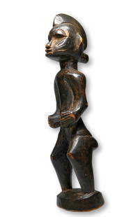
Sold2023A Fine Senufo Sculpture Ex Rene and Maud Garcia, France.A charming carved wooden female effigy with classic face and form, incised linear scar designs and a well handled surface patina. Senufo peoples, Ivory Coast, West Africa. The sculpture measures 6.5 iSee Sold Price
Sold2021Thomas Jefferys (English, 1719-1771)Thomas Jefferys (English, 1719-1771) , "The Isthmus of Panama with the Coast from Great River on the Moskito Shore to Cartagena", London, Laurie & Whittle, 1794, from West India Atlas, 19 in. x 24 1/2See Sold Price
Sold2021(16) 19TH C. MAPS OF THE WEST INDIES IN FOLIO,Including: "L'Isle de Ste. Domingue, et celle de Porto Rico", by Bonne, hand colored engraving,1778, 10" x 14 1/2"; PLUS "West Indies", Smith's Atlas, 1808, hand colored engraving, 1808, 11" x 14"; PLSee Sold Price
Sold2022CHARLES ATLAS - PERSONAL PHOTO COLLECTIONFOLIO OF PHOTOGRAPHS OF CHARLES ATLAS INCLUDING PROMOTIONAL IMAGES, WITH SOME DUPLICATES. ALSO INCLUDED 120 SNAPSHOT PHOTOGRAPHS OF ATLAS IN THE LATE 1960'S TO EARLY 1970'S AT HIS HOME IN WEST PALM BESee Sold Price
Sold2017Map Showing the 4 Voyages of Christopher ColumbusMap: Chart of the West Indies With the Adjacent Coast of South America, Showing The Tracks Of Don Christopher Columbus Size: Folio – 11.00 H x 15.90 W Inches Publisher: George P. Putnam 1849 New YorSee Sold Price
Sold2023Historical Atlas of Solano County, 1877.HISTORICAL ATLAS OF MAP OF SOLANO COUNTY, CALIFORNIA, Compiled, Drawn and Published from Personal Examinations and Surveys. San Francisco: Thompson & West, 1878. Large folio. Half gilt-stamped leatherSee Sold Price
Sold2022Pre-Civil War school atlas map of East Coast states, 1849Very nice map of East Coast states showing Virginia fourteen years before West Virginia becomes a state. Nice example with full original hand coloring. No. 4 Virginia, North Carolina, South Carolina,See Sold Price
Sold2024Blackie (Pub) 1882 Lot of 20 Folio European MapsIncl England, Ireland, Scotland, France, Spain/Portugal, Turkey/Greece, Russia, Scandinavia, Germany etc. Lithograph Maps Published 1882 by Blackie & Son, London for "The Comprehensive Atlas & GeograpSee Sold Price
Sold2023Lizars, Daniel 1831 LG Rare HC Map. France in ProvincesLarge Folio Copper Engraved Map Published 1831-2 by John Hamilton, Successor to Daniel Lizars, Edinburgh for "The Edinburgh Geographical and Historical Atlas..." First Edition by Daniel Lizars. Very fSee Sold Price
5 hrs LeftJeffrey S. Evans & AssociatesGILT-DECORATED CAST-METAL FIGURAL DOG / SETTER WATCH HUTCH / STAND$190(4 bids)
May 16Zikorn Arts & History ObjectsJacques Pierre Maygrier: Nouvelles d'Accouchemens 1822 Ed. 377/2800$50
6 days LeftJasper52Océanique Partie… des Iles Basses 48 SE Tuamotus Polynesia VANDERMAELEN 1827 map$50
6 days LeftJasper52Océanique Partie… des Iles Basses 48 SE Tuamotus Polynesia VANDERMAELEN 1827 map$50
6 days LeftJasper52Océanique Partie… des Iles Basses 43 NE Tuamotus Polynesia VANDERMAELEN 1827 map$65
6 days LeftJasper52Océanique Partie… des Iles Basses 43 NE Tuamotus Polynesia VANDERMAELEN 1827 map$65
6 days LeftJasper52Océanique Iles de la Société #42 Tahiti Rangiroa Polynesia VANDERMAELEN 1827 map$85
6 days LeftJasper52Océanique. Nouvelle Caledonie #46. New Caledonia Vanuatu. VANDERMAELEN 1827 map$85
6 days LeftJasper52Océanique. Nouvelle Caledonie #46. New Caledonia Vanuatu. VANDERMAELEN 1827 map$85
6 days LeftJasper52Océanique Iles de la Société #42 Tahiti Rangiroa Polynesia VANDERMAELEN 1827 map$85
1 day LeftTrillium Antique Prints & Rare BooksBonne - Map of the Eastern Coast of North America$85(3 bids)
6 hrs LeftLeland LittlePicasso and the Human Comedy, A Suite of 180 Drawings by Picasso , American Edition$100(3 bids)
May 14Fleischer's Auctions1755 Map Partie de l'Amerique Septentrionale, qui comprend Le Cours de L'Ohio...$200(3 bids)
1 day LeftRenew GalleryJohn Webber Copper Engraving from James Cook's Voyage "A View of Habitation in Nootka Sound".$20
5 hrs LeftJeffrey S. Evans & AssociatesASSORTED VICTORIAN GLASS VITRINE CASKET-TYPE WATCH HUTCHES / STANDS, LOT OF FIVE$300(6 bids)
5 hrs LeftJeffrey S. Evans & AssociatesPAINT-DECORATED METAL OWL FIGURAL WATCH HUTCH / STAND$190(3 bids)