Sold2024Blaeu Map of the Amazon Region, BrazilBLAEU, Willem Janszoon (1571-1638). Guiana Siue Amazonum Regio. Engraved map with original hand color. Amsterdam, c. 1640. 18 1/2" x 22 3/4" sheet.See Sold Price
Sold20241640 Blaeu Map of Sicily -- Sicilia RegnumTitle: 1640 Blaeu Map of Sicily -- Sicilia Regnum Cartographer: W Baeu Year / Place: 1640 c., Amsterdam Map Dimension (in.): 14.9 X 19.5 in. This is a strikingly attractive larger map of the Kingdom oSee Sold Price
Sold2021Blaeu. Virginia & Florida Map, 1640Blaeu, Willem. VIRGINIAE PARTIS AUSTRALIS, ET FLORIDAE PARTIS ORIENTALIS. Amsterdam, c. 1640. Hand-colored. Framed and matted. Plate 19 7/8" x 15 1/8". As framed 27.5" x 23.25". *************** A niceSee Sold Price
Sold2021Two Early Maps of PolandA map of Poland and Silesia, by W. & J. Blaeu circa 1640 and a map of Poland - Grodków and Nysa by J. Blaeu circa 1660. Dimensions: The frames are 17" x 23" and 19" x 23".See Sold Price
Sold2017Blaeu map of Cyprus c.1640Heading: Author: Blaeu, Willem Title: Cyprus Insula Place Published: Amsterdam Publisher: Date Published: c.1640 Description: Copper-engraved map, hand-colored in outline,See Sold Price
Sold2017Guillaume Blaeu: Map of Russia, Estonia to Moscow, 1660Russiae Vulgo Moscovia dictae Pars Occidentalis. By: Guillaume Blaeu Date: c. 1660 Dimensions: 19.25 x 15 in. (49 x 38.5 cm) This is an attractive early 17th century map showing the region of Russia fSee Sold Price
Sold2022BLAEU, WILLEM Virginiae partis australis et Floridae partis orientalis, interjacentiumq, regionumBLAEU, WILLEM Virginiae partis australis et Floridae partis orientalis, interjacentiumq, regionum Nova Descriptio. Amsterdam: Blaeu, circa 1640. Engraved double-page map with hand-coloring, text on thSee Sold Price
Sold2022Blaeu Novus Brasiliae Typus, c. 1640BLAEU, Willem Janszoon (1571-1638). Novus Brasiliae Typus. Engraved map with original hand color in full. Amsterdam. c. 1640. 18" x 21 7/8" sheet. Fine old color example of Blaeu's first map of BrazilSee Sold Price
Sold2024Willem Blaeu 1640 "Nova Virginiae Tabula" Original Hand Colored Map of VirginiaThis loose (unframed) and very scarce original antique 1640 hand-colored "Nova Virginiae Tabula" map of Virginia is in good overall condition, with light-age appropriate wear and apparent repairs-oneSee Sold Price
Sold2021Jansson 1653 Map of British IslesDESCRIPTION: " Magnae Brittaniae et Hiberniae Nova Descriptio. " Based on Willem Blaeu's 1631 map of the British Isles, this map depicts towns, rivers, an inset of Orkney Islands. Strap work cartoucheSee Sold Price
Sold2022Blaeu Brasilia, c 1640BLAEU, Joan Blaeu (1596-1673). Brasilia... Engraved map with original hand color in part. Amsterdam, c. 1640. 19 7/8" x 23 3/8" sheet. A fine and attractive map of Brasil, first discovered by Pedro ?lSee Sold Price
Sold2015[Map of Russia]. Johannes Blaeu, cartographer. R[Map of Russia]. Johannes Blaeu, cartographer. Russiae, Vulgo Moscovia, Pars AustraSee Sold Price
Sold2019Two Maps by Willem Janszoon Blaeu (1571-1638),Two Maps by Willem Janszoon Blaeu (1571-1638), "Virginiae partis australis et Florida partis orientalis," 1640, hand colored, H. - 15 in., W. - 20 in.; together with India Quae Orientalis Diktur et InSee Sold Price
Sold2024Willem Blaeu, Map of The AmericasAmsterdam, 1617. Together with "Early Maps" by Tony Campbell, Abbeville Press and "The United States in Old Maps and Prints, Eduard Van Ermen. 3 pieces Sight size: 16-1/2"h x 22"w Overall: 23-1/2"h xSee Sold Price
Sold2019Wilem J. Blaeu mapWilem J. Blaeu (Dutch 1571-1638)- Americae Nova Tabula- engraved map with hand-coloring, ca. 1633. 16 1/4 x 21 1/2''See Sold Price
Sold2017Blaeu Map of BrazilMaritima Brasiliae Universa. Joan Blaeu (1596-1673). Engraved map with original color in part. Amsterdam: Blaeu, 1647. 21 x 24 1/2 inches sheet, 32 1/2 x 36 inches framed. This separately issued and rSee Sold Price
Sold20221659 Blaeu Map of Norway -- Norvegia Regnum, vulgo Nor-RykeTitle: 1659 Blaeu Map of Norway -- Norvegia Regnum, vulgo Nor-Ryke Cartographer: J Blaeu Year / Place: 1659 c., Amsterdam Map Dimension (in.): 16.2 X 19.3 in. This is the first large, folio size separSee Sold Price
Sold2018Blaeu Map of Europe -- Europa Recens DescriptaTitle/Content of Map: Blaeu Map of Europe -- Europa Recens Descripta Date: 1635, Amsterdam Cartographer: W Blaeau Size: 16.1 X 21.9 in. This is a grand, large, classic map of Europe, produced at the gSee Sold Price
Sold2018Blaeu: Landmark Map of the AmericasCartographer: Willem Blaeu Place/Date: Amsterdam / 1617/1665 Size: 21 1/2" x 16 1/2" Condition: contemporary color; minor spotting, a few small printer's creases at sides of image. Some waterstainingSee Sold Price
Sold2022[MANUSCRIPT MAP-FLORIDA & MISSISSIPPI RIVER] Map Showing Raiford's Proposed Artificial River and[MANUSCRIPT MAP-FLORIDA & MISSISSIPPI RIVER] Map Showing Raiford's Proposed Artificial River and Plan to Continue the Western and Southern Inland System of Navigation to Harbors in the Atlantic. [FernSee Sold Price
Sold2016Map, Hudson River, Rev. War, Sauthier, 1776At the top of the map is written: "A Topographical Map of Hudsons River, with the Channels Depth of Water, Rocks, Shoals, &c. and the Country Adjacent, from Sandy-Hook, New York and Bay to Fort EdwardSee Sold Price
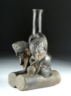
Sold2018Rare Chavin Double Fisherman Stirrup Vessel, TL TestedPre-Columbian, North Coast Peru, Jequetepeque River region, Chavin culture, Tembladera phase, ca. 1200 to 1000 BCE. A fabulous ceramic vessel depicting two fisherman sitting atop a pair of cylindricalSee Sold Price
Sold2015An Early Club New South Wales (early-mid nineteenthAn Early Club Upper Murray River Region, New South Wales (early-mid nineteenth century) carved hardwood 60 cm high PROVENANCE Private Collection, United Kingdom Private CSee Sold Price
Sold2023IATMUL (MWAI) MASKIATMUL (MWAI) MASKPapua New Guinea, Middle Sepik River Region, Iatmul People, first half 20th century. Polychrome decorated carved wood mask having oblong face with elongated zoomorphic nose below a fSee Sold Price
1 day LeftFreeman's | HindmanHOMANN, Johann Baptist. Amplissimae Regionis Mississipi Seu Provinciae Ludovicianae. Nuremburg, [ca$425(2 bids)
Featured6 days LeftJasper521636 Hondius Map of Southern Spain -- Andaluzia continens Sevillam et Cordubam$140
Jun 13Swann Auction Galleries(AMERICAN SOUTHEAST.) Willem Blaeu. Virginiae Partis Australis, et Floridae Partis Orientalis.$375
Featured6 days LeftJasper521680 Wit Map of Southern Netherlands -- Ducatus Geldriae, et Comitatus Zutphaniae, Tabula...$130
1 day LeftFreeman's | Hindman[MAP]. TODESCHI, Pietro. [Nova et Acurata Totius Americae Tabula auct. G.I. Blaeu] America quarta$5,000
1 day LeftFreeman's | Hindman[MAP]. ORTELIUS, Abraham. Peregrinationis Divi Pauli Typus Corographicus. 1592.$150(1 bid)
1 day LeftFreeman's | HindmanMURCHISON, Roderick Impey, Sir. The Silurian System. 1839. COMPLETE WITH VERY RARE HAND-COLORED$1,500


![[Map of Russia]. Johannes Blaeu, cartographer. R: [Map of Russia]. Johannes Blaeu, cartographer. Russiae, Vulgo Moscovia, Pars Austra](https://p1.liveauctioneers.com/906/80657/41935085_1_x.jpg?height=310&quality=70&version=1445283342)


![[MANUSCRIPT MAP-FLORIDA & MISSISSIPPI RIVER] Map Showing Raiford's Proposed Artificial River and: [MANUSCRIPT MAP-FLORIDA & MISSISSIPPI RIVER] Map Showing Raiford's Proposed Artificial River and Plan to Continue the Western and Southern Inland System of Navigation to Harbors in the Atlantic. [Fern](https://p1.liveauctioneers.com/292/250642/130213644_1_x.jpg?height=310&quality=70&version=1654271664)


![[MAP]. TODESCHI, Pietro. [Nova et Acurata Totius Americae Tabula auct. G.I. Blaeu] America quarta (1 of 1)](https://p1.liveauctioneers.com/197/329395/177650542_1_x.jpg?height=282&quality=70&version=1715364962)

![[MAP]. ORTELIUS, Abraham. Peregrinationis Divi Pauli Typus Corographicus. 1592. (1 of 2)](https://p1.liveauctioneers.com/197/329395/177650535_1_x.jpg?height=282&quality=70&version=1715364962)


