Sold20211680 Visscher Map of French and Italian Alpine RegionTitle: 1680 Visscher Map of French and Italian Alpine Region -- Regiae Celsitudinis Sabaudicae Status Cartographer: N Visscher Year / Place: 1680 c. Amsterdam Map Dimension (in.): 22.8 X 19.8 in. ThisSee Sold Price
Sold2023Early Hand Colored Map French Region, approx. 26" X 33"Early Hand Colored Map French Region, approx. 26" X 33"See Sold Price
Sold2017Victor Levasseur, (4) maps French regionsVictor Levasseur, (4) maps French regions, Victor Levasseur (French, 1800-1870), Pyrenees, L'Ariege, and Puy de Dome, c. 1856, hand-colored engravings with vignettes and decorative borders, each 14.5"See Sold Price
Sold201818th Map of French Region PicardieTopographical map of government of Castelet, dated 17th C, printed within an acanthuis border. S:17.5"H x 21.5"W F: 28"H x 31.5"WSee Sold Price
Sold2019Rare map of French region of Lunguedoc with 12 cityTitle/Content of Map: Rare map of French region of Lunguedoc with 12 city views including Montpelier. Date: 1717 Cartographer: Feuille Size: 7.6x10.6” Provenance: Amsterdam Additional Info: OriginalSee Sold Price
Sold20231587 Abraham Ortelius Three part map of Italian Regions1587 Abraham Ortelius Three Part map of Italian Regions, including Anacona , Corsica and Sienna hand colored with some toning, center fold as issued- 13 x 19" 18 x 24" as framed.See Sold Price
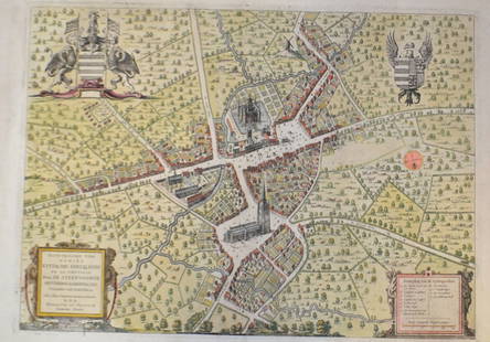
Sold20211750 Homann Map of French Champaigne Region -- TabulaTitle: 1750 Homann Map of French Champaigne Region -- Tabula Geographica Campaniae Cartographer: J Homann [Family] Year / Place: 1750 c., Nurnberg Map Dimension (in.): 22.3 X 19.1 in. This is a lovelySee Sold Price
Sold20211881 Vuillemin Map of French Alsace Region -- LaTitle: 1881 Vuillemin Map of French Alsace Region -- La France. Ht-Rhin Cartographer: A Vuillemin Year / Place: 1881 Paris Map Dimension (in.): 9.4 X 7 in Description: This is a very nice map of the sSee Sold Price
Sold2015-. Ortelius (Abraham) - Thusciae descriptis auctoremap of Tuscany, with 2 other map sheets of Italian regions, Larii Lacus vulgo comensis descriptio (on sheet with Terretorii Romani Descrip. and Fori Iulii vulgo Friuli Typus); and SenensisDitionis AccSee Sold Price
Sold20241602 Ortelius Map of French Le Mans region -- La Mans Cenomanorum TypusTitle: 1602 Ortelius Map of French Le Mans region -- La Mans Cenomanorum Typus Cartographer: A Ortelius Year / Place: 1602, Antwerp Map Dimension (in.): 3 X 4.2 in. This is a charming smaller map of FSee Sold Price
Sold2023VISSCHER C. 1680 PRUSSIA MAPEngraved map, with cartouche of Konigsburg. Center fold as issued. Dimensions: (Paper) H 21" x W 24" Condition: Repaired losses in margins. Handling marks, a few light surface stains.See Sold Price
Sold20181573 Ortelius Map of French Riviera and Italy'sTitle/Content of Map: 1573 Ortelius Map of French Riviera and Italy's Piedmont Region -- Pedemontanae Vicinorumque Regionum Auctore Iacobo Castaldo Descrip Date Printed: 1573, Antwerp Cartographer: ASee Sold Price
Sold2019Cries of London, Color Restrikes [Trades, English]Six color restrike engravings from the 'Cries of London' series, circa 1680's. Each captioned in French, German, Italian and English. Each with a fleur de'lis blind stamp lower right. Each with stickeSee Sold Price
Sold2019Artois region along French Belgian borderTitle/Content of Map: Artois region along French Belgian border Date: 1717Cartographer: by FeuilleSize: 7.6x10.6” Provenance: Amsterdam original hand color/ Note* some damage on left due to strong fSee Sold Price
Sold20244 Antique Maps of Various LocationsFrench Map of Canada By Guillaume Del'Isle, Map Of Asia By Guiljelmo Blaeuw, Double Hemisphere map By Nicolao Visscher, Map Of The Holy Land Jerusalem, all maps are roughly 18" x 14"See Sold Price
Sold201518th C French Map Of SteenvoordePLOUICH, Vedastus du -" Illvstrissimo viro domino" .The city of Steenvoorde is a small town located north of France. The city of Steenvoorde is located in the department of Nord of the french region.See Sold Price
Sold202119TH C. FRENCH ALPINE SAVOYARD BUTTER CHURNAntique butter churn in rare meleze wood, larch, and iron; complete with original churn. Meleze, a hard pine, is only found in the French and Italian High Alps. Barrel and churn have a wonderful patinSee Sold Price
Sold2019MAP - Guyana, Suriname, French Guiana. MontanusGuyana, Suriname, French Guiana. Montanus/Ogilby, Guiana sive Amazonum Regio, 1671 (circa). Hand Color. This decorative map covers the region from the Isla Margarita in the northwest to the coast of nSee Sold Price
Sold2018Italian and French brochuresLamborghini 400 GT 2 + 2, two different Countach, 1950’s Siata, opens to 24 x 8.5, Renault Alpine, Plasticar with Renault 4 CV engine, opens to 22 x 17See Sold Price
Sold2017Alexis Hubert Jaillot (French 1632-1712) map of Asia,Alexis Hubert Jaillot (French 1632-1712) map of Asia, "L' Asie, Distinquee en ses principales Parties. 1687", framed and glazed, "L'asie divisee en ses Principales Regions, et ousepeut voir l'estendueSee Sold Price
Sold2021(5) ORBUS TERRARUM AFTER NICOLAO VISSCHERDecorative reproduction Old style maps of various regions of the world. Dimensions: (Frame) H 18.5" x W 21.5" (Sight) H 14" x W 16.25" Condition: One map missing the glass for frame. Some wear to framSee Sold Price
Sold2022ANTIQUE FRENCH NORMANDY MAPS ENGRAVINGS 17TH CEN.A pair of antique French hand-colored engravings maps. The first is titled, Le Pais De Cavx Normandy Part of Picardy. The Pais or Pays de Caux is a natural region of Normandy belonging to the Paris BaSee Sold Price
Sold2017Antique 19th C French Hand Colored Map of CalvadosAntique 19th C map of the French area of Calvados. This area of France is known for its production of Calvados. The engraving is surrounded by scenes showing the region and its products. Published bySee Sold Price
Sold2023Antique Map Northern Italy, Alps to VeniceCarta Geograpohica e Postale del Regno Lombardo-Venteto. C. Pinchetti, Giuseppe Pezze, Milan: 1848. Italian wall map, folding as dissected on linen. Slip case. Lombardy and Veneto regions of Italy. 17See Sold Price
4 days LeftJasper521680 Jansson/Duval Map of Middle East -- Tabula Itineris Decies Mille Graecorum sub Cyro Contra$140(1 bid)
4 days LeftJasper521846 Quin Map of the Mediterranean and Persia During the Rule of Cyrus -- Fourth period : B.C. 529.$55
5 days LeftHunt and Peck Estate Services, Inc.Jacques Nicolas Bellin Map Of Western Part Of New France Or Canada$200(1 bid)
4 days LeftJasper521792 Elwe Map of Southern Netherlands to Belgium to Northern France -- Carte Nouvelle des Pais Bas$80
4 days LeftJasper521575 Braun and Hogenberg Views of Southern Spanish Towns -- Le Brixa [on Sheet with] Settenil$140
2 days LeftCurated Gallery AuctionsOld Master European Landscape 18th/19th Century French Italian Framed Oil Painting$90(2 bids)
Jun 02Broward Auction GalleryATTRIB Jean Francois de Troy (France,Italy,1679-1752) oil painting antique$1,100(5 bids)
May 16Eldred'sAFTER CLAUDE LORRAIN (France/Italy, circa 1600-1682), "Mercury, Argos and Io", 18th Century.,$150
May 16Hermann Historica GmbHA pair of French or Italian gauntlets with etched embellishment, circa 1600€4,200
May 11ZevantiquesOrnate and Very Elegant 17th-18th C. Spanish French or Italian Left Hand Dagger Wearing a Sturdy$500


![1750 Homann Map of French Champaigne Region -- Tabula: Title: 1750 Homann Map of French Champaigne Region -- Tabula Geographica Campaniae Cartographer: J Homann [Family] Year / Place: 1750 c., Nurnberg Map Dimension (in.): 22.3 X 19.1 in. This is a lovely](https://p1.liveauctioneers.com/5584/227445/117579454_1_x.jpg?height=310&quality=70&version=1638310644)


![Cries of London, Color Restrikes [Trades, English]: Six color restrike engravings from the 'Cries of London' series, circa 1680's. Each captioned in French, German, Italian and English. Each with a fleur de'lis blind stamp lower right. Each with sticke](https://p1.liveauctioneers.com/5755/147592/74586354_1_x.jpg?height=310&quality=70&version=1565302309)


![1575 Braun and Hogenberg Views of Southern Spanish Towns -- Le Brixa [on Sheet with] Settenil (1 of 1)](https://p1.liveauctioneers.com/5584/327462/176400785_1_x.jpg?height=282&quality=70&version=1714507756)


