Sold20211750 Homann Map of French Champaigne Region -- TabulaTitle: 1750 Homann Map of French Champaigne Region -- Tabula Geographica Campaniae Cartographer: J Homann [Family] Year / Place: 1750 c., Nurnberg Map Dimension (in.): 22.3 X 19.1 in. This is a lovelySee Sold Price
Sold2017Harenburg/Homann Heirs: Holy Land, 12 Tribes, 1750Palaestina in XII tribus divisa. Homann's fascinating map of the Holy Land "divided into 12 tribes and it adjacent lands" was "revised and augmented by J.C. Harenburg" according to the French title trSee Sold Price
Sold2023Early Hand Colored Map French Region, approx. 26" X 33"Early Hand Colored Map French Region, approx. 26" X 33"See Sold Price
Sold2017Victor Levasseur, (4) maps French regionsVictor Levasseur, (4) maps French regions, Victor Levasseur (French, 1800-1870), Pyrenees, L'Ariege, and Puy de Dome, c. 1856, hand-colored engravings with vignettes and decorative borders, each 14.5"See Sold Price
Sold201818th Map of French Region PicardieTopographical map of government of Castelet, dated 17th C, printed within an acanthuis border. S:17.5"H x 21.5"W F: 28"H x 31.5"WSee Sold Price
Sold2019Rare map of French region of Lunguedoc with 12 cityTitle/Content of Map: Rare map of French region of Lunguedoc with 12 city views including Montpelier. Date: 1717 Cartographer: Feuille Size: 7.6x10.6” Provenance: Amsterdam Additional Info: OriginalSee Sold Price
Sold20201720 c. Homann Map of Benelux -- Tabula GeneralisTitle/Content of Map: 1720 c. Homann Map of Benelux -- Tabula Generalis Totius Belgii qua Provinciae XVII. Infer. Germaniae olim sub S.R.I. Circulo BurgundiaeÂ… Cartographer: J Homann Year/Place: 1See Sold Price
Sold20211881 Vuillemin Map of French Alsace Region -- LaTitle: 1881 Vuillemin Map of French Alsace Region -- La France. Ht-Rhin Cartographer: A Vuillemin Year / Place: 1881 Paris Map Dimension (in.): 9.4 X 7 in Description: This is a very nice map of the sSee Sold Price
Sold2020EARLY FRENCH MAP OF NEW ENGLANDHand-colored. Ca 1750-1760. Map in French. Map 14 1/2 x 12 1/2 inches. Fold marks and water stains. Overall 21 inches x 19 inches. Stains and cut down.See Sold Price
Sold20241720 Tabula Geographica Homann Map of Black Sea18th Century 1720 Tabula Geographica Homann Map of Black Sea - Tabula Geographica qua pars Russiae Magnae Pontus Euxinus seu Mare Nigrum et Tartaria Minor cum finitimis Bulgariae, et Romaniae et NatolSee Sold Price
Sold20241602 Ortelius Map of French Le Mans region -- La Mans Cenomanorum TypusTitle: 1602 Ortelius Map of French Le Mans region -- La Mans Cenomanorum Typus Cartographer: A Ortelius Year / Place: 1602, Antwerp Map Dimension (in.): 3 X 4.2 in. This is a charming smaller map of FSee Sold Price
Sold20211680 Visscher Map of French and Italian Alpine RegionTitle: 1680 Visscher Map of French and Italian Alpine Region -- Regiae Celsitudinis Sabaudicae Status Cartographer: N Visscher Year / Place: 1680 c. Amsterdam Map Dimension (in.): 22.8 X 19.8 in. ThisSee Sold Price
Sold20181753 Homann Map of the Low Countries: Tabula GeneralisTitle/Content of Map: 1753 Homann Map of the Low Countries: Tabula Generalis Totius Belgii qua Provinciae XVII. Infer. Germaniae olim sub S.R.I. Circulo Burgundiae… Date: 1753 Nurnberg Cartographer:See Sold Price
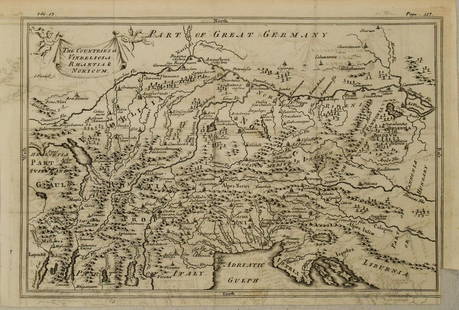
Sold20201750 c. Map of Eastern Alps Region in Ancient Times --Title: 1750 c. Map of Eastern Alps Region in Ancient Times -- The Countries of Vindelicia, Rhaethia & Noricum Cartographer: G Sale et al Year/Place: 1750 c., London Size: 7.8 X 11.8 in. Additional InfSee Sold Price
Sold2017Homann Map of Poland and the Baltic States, 17391739 Homann Map of Poland and the Baltic States: Regni Poloniae Magnique Ducatus Lithuaniae Nova et Exacta Tabula. An outstanding Homann map of Poland, Lithuania, Latvia, Estonia and a portion of RussSee Sold Price
Sold2021French Hand-Colored Map of America, 1750Antique French Hand-Colored Map of America , "Amerique Septentrionale, dressee, sur les Relations les plus modernes...", 1750, Robert de Vaugondy, the cartouche with an alligator flanked by figures, 1See Sold Price
Sold20221716 Homann Map of the Danish Jutland Peninsula -- Tabula Generalis Iutiae, continens DioecesesTitle: 1716 Homann Map of the Danish Jutland Peninsula -- Tabula Generalis Iutiae, continens Dioeceses Quatuor, Alburgensem, Wiburgensem, Ripensem et Arhusiensem… Cartographer: J Homann Year / PSee Sold Price
Sold2017French Carte De L'amerique Map, 1750Map: Carte De L'amerique Publication Date: 1750 ca. Authors: ANONYMOUS Size: Octavo – 7.50 H x 5.50 W Inches Mid 18th Century French "L'Amerique." Shows the Gila River crossing the Colorato River. USee Sold Price
Sold2021SEUTTER - 1750 KINGDOM OF MERCIE FRENCH MAPMatthieu / Matthaus Seutter 1678-1757 - Circa 1750 Kingdom of Mercie Topographical Map. Latin Text La Pius Grande Partie de la Manche, qui contient Les Cotes d'Angleterre et celles de France les bordsSee Sold Price
Sold20181573 Ortelius Map of French Riviera and Italy'sTitle/Content of Map: 1573 Ortelius Map of French Riviera and Italy's Piedmont Region -- Pedemontanae Vicinorumque Regionum Auctore Iacobo Castaldo Descrip Date Printed: 1573, Antwerp Cartographer: ASee Sold Price
Sold20191720 Homann Map of Netherlands, Belgium and LuxemburgReserve Reduced! Map Title/Content: 1720 Homann Map of Netherlands, Belgium and Luxemburg -- Tabula Generalis Totius Belgii qua Provinciae XVII. Infer. Germaniae olim sub S.R.I. Circulo Burgundiae…See Sold Price
Sold20221716 Homann Map of Northern Germany with Hamburg --Title: 1716 Homann Map of Northern Germany with Hamburg -- Tabula Generalis Holsatiae Complectens Holsatiae, Dithmarsiae, Stormariae, et Vagriae Ducatus Cartographer: J Homann Year / Place: 1716, NurnSee Sold Price
Sold2019Artois region along French Belgian borderTitle/Content of Map: Artois region along French Belgian border Date: 1717Cartographer: by FeuilleSize: 7.6x10.6” Provenance: Amsterdam original hand color/ Note* some damage on left due to strong fSee Sold Price
Sold2021French region of Aquitaine, 1762 by Homann HeirsTitle: French region of Aquitaine, 1762 by Homann Heirs Date/Period: 1762 Materials: Copper plate engraved Size: 24 x 20 1/2" 1762, by J. B. Homann & Homann Heirs, from "Atlas Homannianus Mathematico-See Sold Price
3 days LeftJasper521680 Jansson/Duval Map of Middle East -- Tabula Itineris Decies Mille Graecorum sub Cyro Contra$190(2 bids)
5 days LeftHunt and Peck Estate Services, Inc.Jacques Nicolas Bellin Map Of Western Part Of New France Or Canada$200(1 bid)
3 days LeftJasper521792 Elwe Map of Southern Netherlands to Belgium to Northern France -- Carte Nouvelle des Pais Bas$80
3 days LeftJasper521575 Braun and Hogenberg Views of Southern Spanish Towns -- Le Brixa [on Sheet with] Settenil$140
3 days LeftJasper521942 Myra Z Barnes Map of French Quarter, New Orleans -- Le Vieux Carre de la Nouvelle Orleans$95
May 12Schilb Antiquarian Rare Books1844 Siege of Gibraltar American Revolution SPAIN France Drinkwater MAP History$1(1 bid)
3 days LeftJasper521753 Robert de Vaugondy Map of Central France -- Gouvernemens Generaux De La Marche, Du Limosin Et$45


![1750 Homann Map of French Champaigne Region -- Tabula: Title: 1750 Homann Map of French Champaigne Region -- Tabula Geographica Campaniae Cartographer: J Homann [Family] Year / Place: 1750 c., Nurnberg Map Dimension (in.): 22.3 X 19.1 in. This is a lovely](https://p1.liveauctioneers.com/5584/227445/117579454_1_x.jpg?height=310&quality=70&version=1638310644)


![[MAPS]. A group of 3 engraved maps, most with hand-coloring. (1 of 4)](https://p1.liveauctioneers.com/197/328642/177014805_1_x.jpg?height=282&quality=70&version=1714760103)


![1575 Braun and Hogenberg Views of Southern Spanish Towns -- Le Brixa [on Sheet with] Settenil (1 of 1)](https://p1.liveauctioneers.com/5584/327462/176400785_1_x.jpg?height=282&quality=70&version=1714507756)


