Sold20181757 Venegas Map of Baja California -- NaauwkeurigeTitle/Content of Map: 1757 Venegas Map of Baja California -- Naauwkeurige Kaart van California, Uytgegeven door de Maatschappy der Jesuiten, en Opgedragen aan den Koning van Spanjen -- California (penSee Sold Price
Sold2022Important map of Baja California and today’s Arizona c1765. By TirionTitle: Important map of Baja California and today’s Arizona c1765. By Tirion Date/Period: c1765 Materials: Copper plate engraved Size: 14 x 13” AMONG THE BEST AND OLDEST DETAILED MAPS OBTASee Sold Price
Sold2021Map California during the ConquestHeading: Author: U.S. War Department Title: [Untitled map of California from Bodega Bay to San Diego, with inset of lower tip of Baja California and the Gulf of California] Place Published: [WashingtSee Sold Price
Sold202318TH C. M. SEUTTER NOVUS ORBIS SIVE AMERICA MAPCartographer Matthaus Seutter, German (1678-1757). Engraved map with hand-coloring. One of the last maps to feature California as an island. Dimensions: (Frame) H 22.5" x W 25.5" Condition: Not examinSee Sold Price
Sold20171703 Scherer - World Map [California as an Island]Title: World Map [without title] "Map maker: Heinrich Scherer, Atlas Marianus" "Place and Year: Munich, 1703" "Dimensions: 23.6 x 35.5 cm (9.3 x 14 in)" "Technique: Copperplate engraving" "Coloring: USee Sold Price
Sold2022Scarce 1757 map of America in Seven Years' WarMap published in the middle of the French and Indian War. Shows the theater of conflict between eastern Lake Ontario and New England. The war was fought between 1754 and 1763 and was part of a broaderSee Sold Price
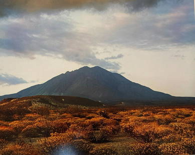
Sold2020ELIOT PORTER Sunset Baja California 1966ELIOT PORTER Sunset Behind Las Tres Virgenes Volcano, Near Mezquilal, Baja California, August 12, 1966, Color Dye Transfer Print 1981 12.5x16" ASG# EP/1342 signed on mount below print right, mounted oSee Sold Price
Sold2023Jose Cisneros, "Vaquero de la Baja California", 1950Jose Cisneros (Texas, 1910-2009), "Vaquero de la Baja California", 1950, pen and ink drawing, includes (2) books by Jose Cisneros: "Faces of the Borderlands" and "Riders of the BorSee Sold Price
Sold20171749 MAP CALIFORNIA AS AN ISLAND, JACQUES CHIQUETFramed map, c. 1749, "L’AMERIQUE SEPTENTRIONALE qui fait partie des Indes Occidentales. Dressée selon les dernieres Relations des Voiageurs et Suivant les nouvelles Observations de Mur. de lSee Sold Price
Sold2023Carte de la Louisiane et pays voisins'. Mississippi basin. BELLIN 1757 mapCAPTION PRINTED BELOW PICTURE: Carte de la Louisiane et Pays Voisins [Map of Louisiana and neighbouring country] DATE PRINTED: 1757 IMAGE SIZE: Approx 23.0 x 31.5cm, 9 x 12.5 inches (Large); Please noSee Sold Price
Sold2023That part of America which was… New England NY St Lawrence. GENTS MAG 1757 mapTitle: That part of America which was… New England NY St Lawrence. GENTS MAG 1757 map Description: A map of that part of America which was the principal seat of war in 1756' by Unattributed (175See Sold Price
Sold20231790 George Anson World Voyage Spain South America HUGE MAP California Island1790 George Anson World Voyage Spain South America HUGE MAP California Island George Anson was an 18th-century British Navy admiral who is noted for his important world voyage in which he circumnavigaSee Sold Price
Sold2023Cartes des Lac du Canada'. The Great Lakes of North America. BELLIN 1757 mapDescriptionCAPTION PRINTED BELOW PICTURE: Cartes des Lac du Canada [Map of the Great Lakes of North America]DATE PRINTED: 1757IMAGE SIZE: Approx 20.5 x 30.0cm, 8 x 11.75 inches (Medium); Please note tSee Sold Price
Sold2022ELIOT PORTER Pencil Signed DYE TRANSFER PRINT Baja California LIMITED EDITION 1966ARTIST: Eliot Porter (American, Illinois & Santa Fe, New Mexico, 1901-1990) TITLE: Sunset behind Las Tres Virgenes Volcano, near Mezquital, Baja, California, August 12, 1966 MEDIUM: Color dye-transferSee Sold Price
Sold2023BRETT WESTON, ROCK FORM, BAJA, CALIFORNIA, 1964-67BRETT WESTON (1911-1993), ROCK FORM, BAJA, CALIFORNIA, 1964-67 vintage gelatin silver print; 9 5/8 x 7 5/8 in. (image); signed, dated recto on mount in pencil. one of 15 photographs from the Baja, CalSee Sold Price
Sold2023BRETT WESTON, TURTLE SKELETONS, BAJA CALIFORNIA, 1964BRETT WESTON (1911-1993), TURTLE SKELETONS, BAJA CALIFORNIA, 1964 vintage gelatin silver print, printed 1964-1967; 7 ½ x 9 1/2 in (image), 16 x 20 in (matted); signed, dated recto on mount; oneSee Sold Price
Sold2021de Fer, Nicolas 1717 World Map. California as Island"Mappe-Monde ou Carte Generale de la Terre" Copper Engraved Map Published 1717, Paris for "Introduction a la Geographie" by Nicolas de Fer. Folds as issued. Paper Size: 14 x 10 inch (36 x 25cm) Very mSee Sold Price
Sold2018Diderot/Vaugondy: Antique Map California & West AmericaTitle/Content of Map: Carte De La Californie Et Des Pays Nord Ouest separes de L'Asie par le Detroit d'Anian… Cartographer: Diderot/de Vaugondy Place & Date: Paris / 1772 Size: 14 3/8" x 11 7/8" ConSee Sold Price
Sold2023Williamson, Lieut. R. S. 1856 LG HC Map. California - First Geological Map"Geological Map of a Part of the State of California" Explored in 1855 by Lieut R. S. Williamson. Prepared to accompany the Report of William P. Blake. THE FIRST GEOLOGY MAP OF CALIFORNIA. Hand ColoreSee Sold Price
Sold20201854 Historia Antigua O Baja CaliforniaHistoria De La Antigua O Baja California Obra Postuma Del Padre Francisco Javier Clavijero, by Nicolas Gorrin de Son Vicente, printed at Mexico by Juan R Navarro, 1854. 252 pages,in two parts first wiSee Sold Price
Sold2024Carte des Nouvelles Philippines'. Caroline islands. BELLIN/SCHLEY 1757 mapCAPTION PRINTED BELOW PICTURE: Carte des Nouvelles Philippines [Map of the New Philippines] The map represents the Caroline islands, and probably other Micronesian islands, off the eastern coast of thSee Sold Price
Sold2021Soil Map California Imperial sheet (second survey)Title: Soil Map California Imperial sheet (second survey) Cartographer: J. Garnett Holmes Publisher: U.S. Department of Agriculture Bureau of Soils Height: 24.1 Width: 16 Shows "Salton Sink" before itSee Sold Price
Sold20211757 Map of Java Sumatra BorneoCarte Des Isles de Java, Sumatra, Borneo & Les Detroits de la Sonde Malaca et Banca Golphe de Siam, by Jacques Bellin, printed at Paris circa 1757. Measures 14 x 10". Fine. Reserve: $60.00 Shipping:See Sold Price
Jun 23Schilb Antiquarian Rare Books1848 Emory Military Reconnaissance 1ed California MAP Indians Texas New Mexico$5(5 bids)
4 days LeftJasper52Carte réduite de la Mer du Sud'. Pacific Ocean. BELLIN/SCHLEY 1757 old map$200
5 days LeftSwann Auction GalleriesRICHARD ERDOES (1912-2008) The Last Days of the Late Great State of California.$600
Jun 27Rail & Road Auctions45 Peices of Western Railroad Paper Ephemera - Southern Pacific, Northern Pacific, Union Pacific,$30(1 bid)
6 days LeftTrillium Antique Prints & Rare BooksMoore & Conder - Map of North America with Canada, California as a Peninsula, Great Lakes, Florida$75(1 bid)


![Map California during the Conquest: Heading: Author: U.S. War Department Title: [Untitled map of California from Bodega Bay to San Diego, with inset of lower tip of Baja California and the Gulf of California] Place Published: [Washingt](https://p1.liveauctioneers.com/642/218849/112379356_1_x.jpg?height=310&quality=70&version=1631988625)

![1703 Scherer - World Map [California as an Island]: Title: World Map [without title] "Map maker: Heinrich Scherer, Atlas Marianus" "Place and Year: Munich, 1703" "Dimensions: 23.6 x 35.5 cm (9.3 x 14 in)" "Technique: Copperplate engraving" "Coloring: U](https://p1.liveauctioneers.com/5584/112867/57947644_1_x.jpg?height=310&quality=70&version=1511920104)


![Carte de la Louisiane et pays voisins'. Mississippi basin. BELLIN 1757 map: CAPTION PRINTED BELOW PICTURE: Carte de la Louisiane et Pays Voisins [Map of Louisiana and neighbouring country] DATE PRINTED: 1757 IMAGE SIZE: Approx 23.0 x 31.5cm, 9 x 12.5 inches (Large); Please no](https://p1.liveauctioneers.com/5584/309982/165835442_1_x.jpg?height=310&quality=70&version=1700599538)


![Cartes des Lac du Canada'. The Great Lakes of North America. BELLIN 1757 map: DescriptionCAPTION PRINTED BELOW PICTURE: Cartes des Lac du Canada [Map of the Great Lakes of North America]DATE PRINTED: 1757IMAGE SIZE: Approx 20.5 x 30.0cm, 8 x 11.75 inches (Medium); Please note t](https://p1.liveauctioneers.com/5584/311630/167410814_1_x.jpg?height=310&quality=70&version=1701439692)


![Carte des Nouvelles Philippines'. Caroline islands. BELLIN/SCHLEY 1757 map: CAPTION PRINTED BELOW PICTURE: Carte des Nouvelles Philippines [Map of the New Philippines] The map represents the Caroline islands, and probably other Micronesian islands, off the eastern coast of th](https://p1.liveauctioneers.com/5584/315733/169293269_1_x.jpg?height=310&quality=70&version=1705443824)


![[Maps & Atlases] Seutter, Matth(ias).: Novus Orbis sive America... (1 of 2)](https://p1.liveauctioneers.com/65/332523/179335174_1_x.jpg?height=282&quality=70&version=1717709447)


