Sold20191763 d'Anville Ancient World Map -- Orbis VeteribusTitle/Content of Map: 1763 d'Anville Ancient World Map -- Orbis Veteribus Notus Auspiciis Serenissimi Principis Ludovici Philippi Aurelianorum Ducis Publici Juris Factus Date: 1763, London CartographeSee Sold Price
Sold20221763 d'Anville Ancient World Map -- Orbis Veteribus Notus Auspiciis Serenissimi Principis LudoviciTitle: 1763 d'Anville Ancient World Map -- Orbis Veteribus Notus Auspiciis Serenissimi Principis Ludovici Philippi Aurelianorum Ducis Publici Juris Factus Cartographer: J d'Anville Year / Place: 1763,See Sold Price
Sold20191823 Lucas Handcolored Map Orbis Veteribus NotusMap of the Ancient world entitled “Orbis Veteribus Notus”, engraved at Baltimore by E. Lucas, Jr. 1823. Hand coloring, Fine condition, measures 14.5 x 11.5”. Reserve: $20.00 Shipping: Domestic:See Sold Price
Sold20221763 LUDOVICI PHILIPPI MAP18th century original map of Europe titled ORBIS VETERIBUS NOTUS by Ludovici Philippi dated 1763. Auetor D'Anville. VG condition, no stains or tears. 21 x 29, framed 23 x 31 inches.See Sold Price
Sold2017Reimer/Kiepert: Antique Map of the Ancient World, 1863Map Ancient World. 'orbis Terrarum Antiquis Notus', 1863 D Reimer / H Kiepert. Berlin. 18 x 14 inches. 1863. Signed Please note that this lot has a confidential reserve. When you leave a bid in advancSee Sold Price
Sold20191763 d'Anville Map of Western Roman Empire from Spain,Title/Content of Map: 1763 d'Anville Map of Western Roman Empire from Spain, England, Germany, Italy to Hungary to Africa -- Orbis Romani Pars Occidentalis Auspiciis Serenissimi Principis . . . MDCCLXSee Sold Price
Sold20231763 Orbis Veteribus Nobis -Santini1763 Santini - Orbis Veteribus Nobis - Mediterrian Map 24 x 32" as framed.See Sold Price
Sold2017Sanson: Antique Map of the Ancient World, 1679Map: Orbis Vetus, et Orbis Veteris Utraque Continens, Terrarumque Tractus Arcticus et Antarctibus Cartographer: Nicholas Sanson Place & Date: Paris / 1679 Size: 21 1/4" x 15" Condition: outline color;See Sold Price
Sold2017Moxon: Geo-religious Map of the Ancient World, 1671Map: Totius Orbis Terrarum Tabula, Eiusque Post Diluvium Divisio Inter Filios Noachi Cartographer: J. Moxon Place & Date: London / 1671 Size: 13" x 8" Condition: outline color; overall age toning A faSee Sold Price
Sold20221814 map of the Old World, WilkinsonExcellent map of the Old World titled “Terra Veteribus Nota” (Land of the Old) from An Atlas Of Ten Select Maps Of Ancient Geography Both Sacred And Profane; With A Chronological Table OfSee Sold Price
Sold2020ANCIENT WORLD MAP GLASS-TOP COFFEE TABLERectangular coffee table, late 20th c., the inset glass top with printed maps of the ancient world, rising on stretcher joined squared legs, approx 18"h, 40.5"w, 34.5"d Start Price: $80.00See Sold Price
Sold2017Ancient World Maps, Mela Posidonius & Ptolemy 1683 MapAncient World. Maps by Mela, Posidonius & Ptolemy. Mallet 1683 Old Antique. Title of the Map: 'globe De Mella; Globe De Posidonius; Globe De Ptolomee' date Printed: 1683 image Size: Approx Overall PagSee Sold Price
Sold20241839 Known Ancient World Map by MoninTitle: 1839 Known Ancient World Map by Monin Date/Period: 1839 Materials: Hand colored, engraved Size: 17 1/2 x 12 1/2" This map is a fascinating illustration of the world as known to the ancient GreeSee Sold Price
Sold20211838 Ancient World MapAuthor: Delamarche Title: 1838 Ancient World Map Medium: Ink on Paper Dimenions: 18.5"X13" Description: World map dated 1838. Captures the World according to ancient greeks-Homer and Hexiode. EngravedSee Sold Price
Sold20211828 Ancient World MapAuthor: Hall Title: 1828 Ancient World Map Medium: Ink on Paper Dimensions: 10.5"X8.5" Map of the Ancient World dated 1828. Part of Butler's Antique World Atlas. Drawn and engraved by Sydney Hall. PubSee Sold Price
Sold2023Mercator, Rumold (1545-1599) World MapAn engraved double-page double hemispheric world map, "Orbis Terrae Compendiosa Descriptio". Dimensions:Sight is 11 1/4" x 20 3/4", the frame 21" x 29 1/2". Provenance:From a Philadelphia Collection.See Sold Price
Sold2024Nicolaes Van Geelkercken, 1632 world mapNicolaes Van Geelkercken, 1632 world map, Orbis Terrarum Descriptio Duobis Planis Hemisphaeriis Comprehesa, hand-colored engraving, 20th c. restrike, matted and framed under glass, 17"h x 23"w (sight)See Sold Price
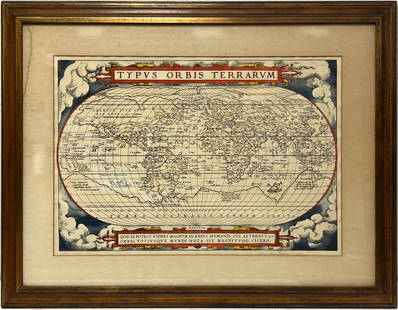
2023Early World Map "Typvs Orbis Terrarvm" Hand ColorDated 1590 near bottom legend box. Hand colored, with red and orange watercolor prominent in the titles. Blue clouds in border. Some slight use of yellow in the boundaries of the map. With signature oSee Sold Price
Sold2017Launay World Map - Typus Orbis Terrarum, 1720Map: Launay World Map - Typus Orbis Terrarum Cartographer: C. Launay Date: ca. 1720 Size: 5 x 8 inches A quite rare, unique and charming double hemisphere map showing very rough approximations for theSee Sold Price
Sold20186 Maps incl: Seutter. Majestas Austriaca...[Austria/DC/Ancient World] 6 Maps. ++ Matthaus Seutter. Majestas Austriaca… C. 1730s-1740s. Detailed map showing rivers and towns in Austria. Hand colored. Border: 19 1/8 x 22 in. Frame: 30 1/2 x 35See Sold Price
Sold2016[World Map]. Rumold Mercator. Orbis terrae compe[World Map]. Rumold Mercator. Orbis terrae compendiosa descriptio.&See Sold Price
Sold201918th C Map Ancient World JerusalemEngraved plate showing maps of ancient world including inset of Judea and Samaria and one of Jerusalem. Early 18th century.Very Good, trimmed to plate lines, measures 7 x 5.5". Reserve: $20.00 ShippinSee Sold Price
Sold2022Buffon & Tardieu 1853 Map. Ancient World"Carte de l'Ancien Continent" Steel Engraved Map with outline hand color Published 1853-55, Paris for "Oeuvres Completes de Buffon" by the Comte de Buffon. Engraved by Ambroise Tardieu. Paper Size: 10See Sold Price
4 days LeftTrillium Antique Prints & Rare BooksPtolemy & Magini, pub. 1620 - Map of the Ancient World with Africa, Europe, Asia$50
May 09Hunt and Peck Estate Services, Inc.Abraham Ortelius map of Bitiurigum from Theatrum Orbis Terrarum$50
8 hrs LeftJasper521886 Adams Chronological Chart of Civilizations -- A Chronological Chart of Ancient, Modern and$550
4 days LeftTrillium Antique Prints & Rare BooksBraun & Hogenberg, pub. 1575 - View of Cusco, Peru and Mexico$100(1 bid)
4 days LeftTrillium Antique Prints & Rare BooksBraun & Hogenberg, pub. 1575 - View of Jerusalem, Israel$100(1 bid)
4 days LeftTrillium Antique Prints & Rare BooksBraun & Hogenberg, pub. 1575 - View of Ghent, Belgium$100
4 days LeftTrillium Antique Prints & Rare BooksBraun & Hogenberg, pub. 1575 - View of Rotterdam, Netherlands$100
4 days LeftTrillium Antique Prints & Rare BooksBraun & Hogenberg, pub. 1575 - View of Innsbruck, Germany$100
8 hrs LeftJasper521699 Moll World Map with Cowley's Voyages -- Nouvelle Carte du Monde Suivant l'idee de Mercator ou$240
Featured8 hrs LeftJasper521719 Chatelain World Map -- Mappe-Monde pour Connoitre les Progres & les Conquestes les Plus$280
Featured7 hrs LeftJasper521771 ASTRONOMY by Joseph M. de La Lande 2 VOLUMES ILLUSTRATED antique in FRENCH$480
May 11Oriental Art AuctionsA COLOSSAL SCULPTED WHITE MARBLE MODEL OF THE HEAD OF HERCULES, 20TH CENTURY€9,000
8 hrs LeftJasper52c1720 World showing Dutch East India Co possessions. CA as a island. By J.Malherbe$650
8 hrs LeftJasper52New Map of That Portion of North America Exhibiting the United States and Territories...Mexico...$360


![6 Maps incl: Seutter. Majestas Austriaca...: [Austria/DC/Ancient World] 6 Maps. ++ Matthaus Seutter. Majestas Austriaca… C. 1730s-1740s. Detailed map showing rivers and towns in Austria. Hand colored. Border: 19 1/8 x 22 in. Frame: 30 1/2 x 35](https://p1.liveauctioneers.com/179/122672/62428327_1_x.jpg?height=310&quality=70&version=1527272450)
![[World Map]. Rumold Mercator. Orbis terrae compe: [World Map]. Rumold Mercator. Orbis terrae compendiosa descriptio.&](https://p1.liveauctioneers.com/906/93415/47683584_1_x.jpg?height=310&quality=70&version=1473203012)


