Sold20221763 d'Anville Ancient World Map -- Orbis Veteribus Notus Auspiciis Serenissimi Principis LudoviciTitle: 1763 d'Anville Ancient World Map -- Orbis Veteribus Notus Auspiciis Serenissimi Principis Ludovici Philippi Aurelianorum Ducis Publici Juris Factus Cartographer: J d'Anville Year / Place: 1763,See Sold Price
Sold20191763 d'Anville Ancient World Map -- Orbis VeteribusTitle/Content of Map: 1763 d'Anville Ancient World Map -- Orbis Veteribus Notus Auspiciis Serenissimi Principis Ludovici Philippi Aurelianorum Ducis Publici Juris Factus Date: 1763, London CartographeSee Sold Price
Sold20191763 d'Anville Map of Western Roman Empire from Spain,Title/Content of Map: 1763 d'Anville Map of Western Roman Empire from Spain, England, Germany, Italy to Hungary to Africa -- Orbis Romani Pars Occidentalis Auspiciis Serenissimi Principis . . . MDCCLXSee Sold Price
Sold20221763 LUDOVICI PHILIPPI MAP18th century original map of Europe titled ORBIS VETERIBUS NOTUS by Ludovici Philippi dated 1763. Auetor D'Anville. VG condition, no stains or tears. 21 x 29, framed 23 x 31 inches.See Sold Price
Sold20191823 Lucas Handcolored Map Orbis Veteribus NotusMap of the Ancient world entitled “Orbis Veteribus Notus”, engraved at Baltimore by E. Lucas, Jr. 1823. Hand coloring, Fine condition, measures 14.5 x 11.5”. Reserve: $20.00 Shipping: Domestic:See Sold Price
Sold20191764 d'Anville Map of Eastern Roman Empire from BlackTitle/Content of Map: 1764 d'Anville Map of Eastern Roman Empire from Black Sea Region to Middle East -- Orbis Romani Pars Orientalis Auspiciis Serenissimi Principis . . . MDCCLXIV Date: 1764, LondonSee Sold Price
Sold2017Reimer/Kiepert: Antique Map of the Ancient World, 1863Map Ancient World. 'orbis Terrarum Antiquis Notus', 1863 D Reimer / H Kiepert. Berlin. 18 x 14 inches. 1863. Signed Please note that this lot has a confidential reserve. When you leave a bid in advancSee Sold Price
Sold20221765 d'Anville Map of Ancient Egypt -- Aegyptus Antiqua Mandato Serenissimi Delphini Publici JurisTitle: 1765 d'Anville Map of Ancient Egypt -- Aegyptus Antiqua Mandato Serenissimi Delphini Publici Juris Facta. . . MDCCLXV Cartographer: J d'Anville Year / Place: 1765, London Map Dimension (in.): 2See Sold Price
Sold2017Sanson: Antique Map of the Ancient World, 1679Map: Orbis Vetus, et Orbis Veteris Utraque Continens, Terrarumque Tractus Arcticus et Antarctibus Cartographer: Nicholas Sanson Place & Date: Paris / 1679 Size: 21 1/4" x 15" Condition: outline color;See Sold Price
Sold2023Mercator, Rumold (1545-1599) World MapAn engraved double-page double hemispheric world map, "Orbis Terrae Compendiosa Descriptio". Dimensions:Sight is 11 1/4" x 20 3/4", the frame 21" x 29 1/2". Provenance:From a Philadelphia Collection.See Sold Price
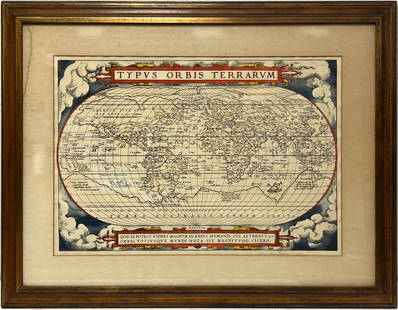
2023Early World Map "Typvs Orbis Terrarvm" Hand ColorDated 1590 near bottom legend box. Hand colored, with red and orange watercolor prominent in the titles. Blue clouds in border. Some slight use of yellow in the boundaries of the map. With signature oSee Sold Price
Sold2016[World Map]. Rumold Mercator. Orbis terrae compe[World Map]. Rumold Mercator. Orbis terrae compendiosa descriptio.&See Sold Price
Sold2017World mapWorld map 'Nova Totius Terraum Orbis Geographica Ac Hydrographica Tabula', copper engraving map of Heinrich Hondius, dated 1630,two hemispheres the world map, surrounded by rich allegorical representaSee Sold Price
2022Blaeu, Johannes (Netherlands, 1596-1673) "The New World Map" Double Hemisphere World Map C. 1664Nova et Accuratissima Totius Terrarum Orbis Tabula Translated "The New World Map", Hand Colored w/ Elaborately Decorated Spandrels.   Sight View 16" x 21-1/2", Overall View 21" x 25-1/2"See Sold Price
Sold2024Petrus Plancius, Engraved World MapOrbis Terrarum Typus de Integro Multis in Locis Emendatus. Petrus Plancius (1552-1622). Copper-plate engraving with original hand color in full. Amsterdam, 1594. Some stains, creases, folds. Sight sizSee Sold Price
Sold2018Ortelius' 1570 world mapHeading: Author: Ortelius, Abraham Title: Typus Orbis Terrarum Place Published: Antwerp Publisher: Date Published: 1570-[1584?] Description: Copper-engraved map, hand-colorSee Sold Price
Sold2020Mercator World Map*** START PRICE IS THE RESERVE *** [World] MERCATOR, Rumold (1545-1599). Orbis Terrae Compendiosa Descriptio Quam ex Magna Universali Mercatoris... Engraved Map with original hand color. Geneva, 1587.See Sold Price
Sold2016Beautifully Colored Jan Van Loon World MapOrbis Terrarum Nova... Jan Van Loon (c. 1611-1686). Engraved map with original hand color in full. London: Moses Pitt, 1680. 17 3/4 x 21 inches visible, 28 1/4 x 31 3/4 inches framed. A fine example oSee Sold Price
Sold2016Celebrated 16th Century World Map by Abraham OrteliusTypvs Orbis Terrarvum, Antwerp, dated 1587, with hand-coloring; Spanish text on the back credits the cartographer's sources in this updated edition showing the Solomon Islands and a corrected South AmSee Sold Price
Sold2022World.- Plancius (Petrus) Orbis Terrarum Typus de Integro Multis in Locis Emendatus auctore PetroWorld.- Plancius (Petrus) Orbis Terrarum Typus de Integro Multis in Locis Emendatus auctore Petro Plancio, double-hemisphere world map, after Mercator's world map of 1587, and the first map to show JaSee Sold Price
Sold2020MERCATOR, RUMOLD. Orbis Terrae Compendiosa Descriptio.MERCATOR, RUMOLD. Orbis Terrae Compendiosa Descriptio. Double-page engraved double-hemispheric world map. 14½x21 inches sheet size, upper and lower margins wide, others narrow, French text on verSee Sold Price
2022Allard, Carel (Netherlands, 1648-1709) World Map C.1696Flat Globe Commonly Called The Whole World Sight View 20-1/2" x 23-3/4", Overall 21-1/4" x 25" "Planispharium Terrestre, Sive Terrarum Orbis, Planispearice Constructi Representatio QuintupleSee Sold Price
Sold2017Framed Colored Engraved 17th C. World Map"Nova Totius Terrarum Sive Novi Orbis Tabula" Framed Colored Engraved 17th C. World Map by Willem Janszoon Blaeu - This interesting piece is an early world map created by Willem Janszoon Blaeu. The maSee Sold Price
Sold2022Wells' world map with California an Island 1700Heading: Author: Wells, Edward Title: A New Map of the Terraqueous Globe according to the Ancient Discoveries and most general Divisions of it into Continents and Oceans Place Published: London PubliSee Sold Price
May 09Hunt and Peck Estate Services, Inc.Abraham Ortelius map of Bitiurigum from Theatrum Orbis Terrarum$50
12 hrs LeftJasper521886 Adams Chronological Chart of Civilizations -- A Chronological Chart of Ancient, Modern and$550
4 days LeftTrillium Antique Prints & Rare BooksBraun & Hogenberg, pub. 1575 - View of Cusco, Peru and Mexico$100(1 bid)
4 days LeftTrillium Antique Prints & Rare BooksBraun & Hogenberg, pub. 1575 - View of Jerusalem, Israel$100(1 bid)
4 days LeftTrillium Antique Prints & Rare BooksBraun & Hogenberg, pub. 1575 - View of Ghent, Belgium$100
5 hrs LeftRapid Estate Liquidators and Auction GalleryLaminated Unique Media The World Map 1996 Edition$15
Featured11 hrs LeftJasper521771 ASTRONOMY by Joseph M. de La Lande 2 VOLUMES ILLUSTRATED antique in FRENCH$480
12 hrs LeftJasper52New Map of That Portion of North America Exhibiting the United States and Territories...Mexico...$360
May 14Akiba Galleries(2 Pc) Allain Manesson Mallet Description De L'Univers 2 Vol. German Translation$200(1 bid)
May 16Potter & Potter AuctionsBOUCHER, Lucien (1889 – 1971). Provence Breguet 763 / Air F...$300
May 12Schilb Antiquarian Rare Books1977 JRR Tolkien 1st ed 1st Printing Silmarillion Lord of the Rings + MAP + DJ$200(5 bids)


![[World Map]. Rumold Mercator. Orbis terrae compe: [World Map]. Rumold Mercator. Orbis terrae compendiosa descriptio.&](https://p1.liveauctioneers.com/906/93415/47683584_1_x.jpg?height=310&quality=70&version=1473203012)


![Ortelius' 1570 world map: Heading: Author: Ortelius, Abraham Title: Typus Orbis Terrarum Place Published: Antwerp Publisher: Date Published: 1570-[1584?] Description: Copper-engraved map, hand-color](https://p1.liveauctioneers.com/642/127929/65081054_1_x.jpg?height=310&quality=70&version=1537227236)
![Mercator World Map: *** START PRICE IS THE RESERVE *** [World] MERCATOR, Rumold (1545-1599). Orbis Terrae Compendiosa Descriptio Quam ex Magna Universali Mercatoris... Engraved Map with original hand color. Geneva, 1587.](https://p1.liveauctioneers.com/1968/163248/82424686_1_x.jpg?height=310&quality=70&version=1583340284)


