Sold20211786 Jefferys Map of Canadian Maritime Provences and USTitle: 1786 Jefferys Map of Canadian Maritime Provences and US New England -- A New Map of Nova Scotia, and Cape Breton Island with the Adjacent Parts of New England and Canada Cartographer: T JefferySee Sold Price
Sold20211756 Seutter/Lotter Map of Canadian Maritime ProvincesTitle: 1756 Seutter/Lotter Map of Canadian Maritime Provinces and Maine -- Partie Orientale de la Nouvelle France ou du Canada avec l'Isle de Terre-Neuve et de Nouvelle Ecosse, Acadie et Nouv. AngleteSee Sold Price
Sold20201780 - Antique map of Canadian Maritime Provinces. 1780Title/Content of Map: 1780 - Antique map of Canadian Maritime Provinces. 1780 Cartographer: Rigobert Bonne Date Printed: 1780 Description: Colonial Northeastern United States & Canada. Rigobert Bonne,See Sold Price
Sold20191876 Mitchell Map of Canadian Maritime Provinces --Title/Content of Map: 1876 Mitchell Map of Canadian Maritime Provinces -- County Map of Nova Scotia, New Brunswick, Cape Breton Id. and Prince Edward's Id. Date: 1876 Philadelphia Cartographer: S MitcSee Sold Price
Sold20161940’s-1960’s Canadian & U.S. Road MapsLot of 19 assorted 1940’s-1960’s Canadian & U.S. recreational, sightseeing & state highway system maps includes: Alabama highway, Pennsylvania highway, Maine highway, New Jersey highway, New YorkSee Sold Price
Sold2017Mitchell: Map of North America, 1848North America, S. Augustus Mitchell, 1848. 13 x 15.75 inches. Great transitional map showing political boundaries within that short time period after the Canadian/U.S. boundary settlement and before tSee Sold Price
Sold2019Mitchell: Canadian Maritime Provinces with HalifaxMap Title: County Map of Nova Scotia New Brunswick Cape Breton Id. and Pr. Edward's Id. Cartographer: S. A. Mitchell Place / Date: Philadelphia / 1870 Size: 10 5/8" x 13 3/8" Condition: wash color; ovSee Sold Price
Sold20151845 MITCHELL'S REFERENCE & DISTANCE WALL MAP U.S.SHOWING MITCHELL'S 1845 REFERENCE AND DISTANCE WALL MAP OF THE UNITED STATES WITH GENERAL MAP OF THE US WITH CONTIGUOUS BRITISH AND MEXICAN POSSESSIONS.PHILADELPHIA : S. AUGUSTUS MITCHELL COPPER-ENGRASee Sold Price
Sold2024Thomas Jefferys - Map of Hungary with Turky in Europe [shows Cyprus]Hand-coloured decorative map of Hungary, Greece, Turkey, Cyprus, and the Gulf of Venice, showing provinces, towns, islands, rivers, etc. Thomas Jefferys (ca. 1719-1771) was a prolific map publisher, eSee Sold Price
Sold2017DIDIER ROBERT DE VAUGONDY (FRENCH, 1723-1786) MAP OFDIDIER ROBERT DE VAUGONDY (FRENCH, 1723-1786) MAP OF VIRGINIA AND MARYLAND hand-colored engraving on laid paper, "Carte De La Virginie, Et Du Maryland", from De Vaugondy's "Atlas Universel", publishedSee Sold Price
Sold2017William Faden 1796 Map Eastern US, North AmericaFaden, William (BRITISH, 1749-1836); Map of the Eastern United States, North American with British Territories and Those of Spain according to the Treaty of 1784 (from a larger atlas), 1796; handcolorSee Sold Price
Sold2020Map of U.S., 1846*** START PRICE IS THE RESERVE *** [America] HAVEN & EMMERSON. Map of the United States and Mexico Including Oregon, Texas and the Californias. Engraved map with original hand color. New York, 1846. 1See Sold Price
Sold2017French and Indian War, Thomas Jefferys' Broadside MapJefferys, Thomas. North America From the French of Mr D'Anville Improved with the Back Settlements of Virginia and Course of Ohio Illustrated with Geographical and Historical Remarks. London: 1755. CoSee Sold Price
Sold2023MAP, Mid-Atlantic US, HomannMap Created to Promote German Immigration to the New World. Colonial Mid-Atlantic United States. Johann Baptist Homann, Virginia Marylandia et Carolina in America Septentrionali Britannorum IndustriaSee Sold Price
Sold2020Johnston Map of U.S. 1844*** START PRICE IS THE RESERVE *** [America] JOHNSTON, Alexander Keith (1804-1871). United States and Texas. Lithograph with original color. London, 1844. 21 1/8" x 26 1/8" sheet. Comparable: Old WorlSee Sold Price
Sold20181854 Thayer, Bridgman, Fanning Map of US, Mexico andTitle/Content of Map: 1854 Thayer, Bridgman, Fanning Map of US, Mexico and Caribbean -- Map of the United States, Canada, Mexico, and the West Indies with Central America, Showing All the Routes to CaSee Sold Price
Sold2021Early English map of U.S. 1783Heading: Author: Kitchin, Thomas Title: Map of the United States in North America: with the British, French and Spanish Dominions adjoining, according to the Treaty of 1783. Place Published: London PSee Sold Price
Sold20221856 Colton Map of Canadian Maritimes and FishingTitle: 1856 Colton Map of Canadian Maritimes and Fishing Rights -- Colton's New Brunswick, Nova Scotia, Newfoundland and Prince Edward Id. Cartographer: GW and CB Colton Year / Place: 1856, New York MSee Sold Price
Sold2019MAPS - Maine. U.S. Gov.Maine. U.S. Gov., [Lot of 2] Map of the Northern Part of the State of Maine and of the Adjacent British Provinces... [and] Extract from a Map of the British and French Dominions in North America, 1838See Sold Price
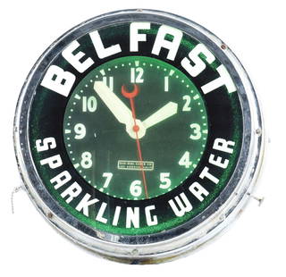
Sold2022WORKING BELFAST SPARKLING WATER ADVERTISING CLOCK.Early Belfast Sparkling Water clock with label that reads "Glo-Dial Clock Co. / Los Angeles, Calif.". Canadian and US patents are present. Overall scattered wear on outer ring of chrome part of clock,See Sold Price
Sold2022HAMILTON MARINE CHRONOMETER.The Chronometer is one of 800 made for the U.S. Maritime Commission. It is model 21 with 14 jewels by the Hamilton Watch Company. It has an uncut bimetallic balance wheel and an Elanor hairspring andSee Sold Price
Sold2020Mitchell Map of Western U.S.*** START PRICE IS THE RESERVE *** [America] MITCHELL, Samuel Augustus (1792-1868). A New Map of Texas, Oregon and California with the Regions Adjoining. Engraving with original hand color, with origiSee Sold Price
Sold2021Great 1860s map of the Maritime Provinces by MitchellTitle: Great 1860s map of the Maritime Provinces by Mitchell Description: This beautiful and detailed historical map depicts the Maritime Provinces (Nova Scotia, New Brunswick and Prince Edward’s IsSee Sold Price
4 days LeftTremont Auctions1778 "Il Canada" original map depicting Canada and the US. Hand colored. Fold down center. Framed.$150(1 bid)
May 09Hunt and Peck Estate Services, Inc.1794 Laurie & Whittle after Thomas Jefferys Map Of The United States Of America$340(1 bid)
6 days LeftJasper521884 Rand McNally Map of US Railroad System -- Map Exhibiting the Several Pacific Railroads Prepared$140
May 10Rail & Road AuctionsEleven Army Corps of Engineers Port Series No. 1 Through No. 8 Books with Fold Out Maps$35(2 bids)
May 10Rail & Road AuctionsEleven Port Series Books with Fold Out Maps - No. 9 Through No. 23 - Army Corps of Engineers$20(1 bid)
4 days LeftKellie's Estate SalesWool Hudson Bay 4 Point Blanket England Approximately 9'x 7'$105(2 bids)
Featured37 mins LeftJasper52PACIFIC OCEAN currents British French German US Spanish colonies. LETTS 1889 map$15
May 09Hunt and Peck Estate Services, Inc.Jacques Nicolas Bellin Map Of Western Part Of New France Or Canada$200(1 bid)
Featured37 mins LeftJasper52NW Coast of America & NE Coast of Asia… ROBERTS / DELAROCHETTE. Pacific 1794 map$700(1 bid)


![Thomas Jefferys - Map of Hungary with Turky in Europe [shows Cyprus]: Hand-coloured decorative map of Hungary, Greece, Turkey, Cyprus, and the Gulf of Venice, showing provinces, towns, islands, rivers, etc. Thomas Jefferys (ca. 1719-1771) was a prolific map publisher, e](https://p1.liveauctioneers.com/8353/325198/175261422_1_x.jpg?height=310&quality=70&version=1712598926)


![Map of U.S., 1846: *** START PRICE IS THE RESERVE *** [America] HAVEN & EMMERSON. Map of the United States and Mexico Including Oregon, Texas and the Californias. Engraved map with original hand color. New York, 1846. 1](https://p1.liveauctioneers.com/1968/163248/82424576_1_x.jpg?height=310&quality=70&version=1583340284)


![Johnston Map of U.S. 1844: *** START PRICE IS THE RESERVE *** [America] JOHNSTON, Alexander Keith (1804-1871). United States and Texas. Lithograph with original color. London, 1844. 21 1/8" x 26 1/8" sheet. Comparable: Old Worl](https://p1.liveauctioneers.com/1968/163248/82424588_1_x.jpg?height=310&quality=70&version=1583340284)


![MAPS - Maine. U.S. Gov.: Maine. U.S. Gov., [Lot of 2] Map of the Northern Part of the State of Maine and of the Adjacent British Provinces... [and] Extract from a Map of the British and French Dominions in North America, 1838](https://p1.liveauctioneers.com/6576/142214/71976779_1_x.jpg?height=310&quality=70&version=1557929467)

![Mitchell Map of Western U.S.: *** START PRICE IS THE RESERVE *** [America] MITCHELL, Samuel Augustus (1792-1868). A New Map of Texas, Oregon and California with the Regions Adjoining. Engraving with original hand color, with origi](https://p1.liveauctioneers.com/1968/163248/82424595_1_x.jpg?height=310&quality=70&version=1583340284)


