Sold20231821 Antigua West Indies Map / W. Phillips London1821 Island of Antigua West Indies Map / W. Phillips London. Map measures 8 inches H x 10.25 W within matting, framed, 12.5 x 15 inches.See Sold Price
Sold2017Woodbridge: Antique Map of North America & West IndiesWOODBRIDGE, W.C. . London: Whittaker, 1821. From "Modern Atlas". Approximately 8-1/2 x 10-1/2, in plastic sleeve. Right margin a little close trimmed (no loss of image), else fine. Depicts the North ASee Sold Price
Sold202319th C. Maps, West Indies Gulf of Mexico (3pc)Three Hand Colored 19th C. Maps of The West Indies, Gulf of Mexico: (1) Map titled "CARACCAS AND GUYANAS" Published 1822, Sherwood Neely & Jones, London, good condition, measures: 8.5"H x 10.5" W, (1)See Sold Price
Sold2023Findlay, Alexander 1828 Map. West Indies CaribbeanCopper Engraved Map Published 1828, London for "The Oxford Encyclopaedia: Or, Dictionary of Arts, Sciences and General Literature" by Rev. W. Harris, J. A. Stewart, C. Butler, Rev. J. H. Hinton et al.See Sold Price
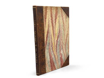
Sold2023Montule: Voyage to North America"A Voyage to North America, and the West Indies in 1817", E. Montule. First edition. London. Printed for Sir Richard Phillips and Co. 1821. 9-1/2in tall x 6in wide. | Philadelphia Metro area delivery,See Sold Price
Sold2019Richard William Seale (1732-1775, London), "A map ofRichard William Seale (1732-1775, London), "A map of North America with the European Settlements...West Indies," c. 1745, H. - 15 7/8 in., W. - 120 3/8 in.See Sold Price
Sold2019Gibson: West IndiesMap Title: West Indies Cartographer: Gibson Place/Date: London / 1758/1792 Size: 3 3/4" x 2 1/2" Condition: b&w; light overall age toning A later edition of the delightfully detailed miniature West InSee Sold Price
Sold2020Raynal "History of Trade in the East and West IndGuillaume Thomas Raynal (1713-1796), tr. J.O. Justamond, F.R.S., "A Philosophical and Political History of the Settlements and Trade of Europeans in the East and West Indies," London: W. Strahan and TSee Sold Price
Sold2022Antigua, Guadeloupe & Marie-Galante. West Indies Caribbean. THOMSON 1817 mapTITLE/CONTENT OF MAP: 'Antigua. Guadaloupe. Mariegalante &c' A map of the French and British Leeward islands of Guadeloupe, Marie-Galante & Antigua DATE PRINTED: Published in 1817 IMAGE SIZE: Approx 5See Sold Price
Sold20211832 West Indies MapTitle: 1832 West Indies Map Author: Dower Medium: Ink on Paper Dimensions: 12"X9.5" Map of the West Indies dated 1832. Published by Orr & Co in London. Part of Dower's Atlas of Modern Geography. Key uSee Sold Price
Sold2017Guthrie/Dilly & Robinson: Map of West Indies, 1785Map: The West Indies According to the best Authorities. Cartographer: William Guthrie / Dilly & Robinson Place & Date: London / 1785 Size: 20 1/2" x 11" The West Indies map from Guthrie's New System oSee Sold Price
Sold2018Fullarton: Antique Map of the West Indies, 1845Title/Content of Map: West Indies. Cartographer: A. Fullerton Place & Date: London / 1845 Size: 9 3/4" x 7 3/4" Condition: outline color; light overall age toning Fullerton's small West Indies map disSee Sold Price
Sold2019Two Maps by Thomas Kitchin (1718-1774), "Map of theTwo Maps by Thomas Kitchin (1718-1774), "Map of the countries on the South Sea from Panama to Guayquil," 1821, together with "West Indies agreeable to the most approved Maps and Charts," 1782, South SSee Sold Price
Sold2017Jamaica British West Indies Antique Map, 1835Map: Jamaica British West Indies Antique Map Size: 15.5"W × 0.1"D × 13.0"H Year: 1835 Please note that this lot has a confidential reserve. When you leave a bid in advance of the auction, submit youSee Sold Price
Sold20191740 Magazine w/ Map Vera CruzThe May 1740 issue of Gentleman’s Magazine 56 pages including a small folding map of the port of Vera Cruz in New Spaine. Also description of the West Indies Islands with brief descriptions of JamaiSee Sold Price
Sold2021Russell, William 1778 Rare Map of The West Indies"The West Indies and Gulf of Mexico" Copper Engraved Map Published 1778, London for "The History of America, From Its Discovery by Columbus to the Conclusion of the Late War" by William Russell. EngraSee Sold Price
Sold2018Russel: Antique Map of West Indies/Gulf of Mexico, 1796Title/Content of Map: West Indies. Cartographer: J. Russel Place & Date: London / 1796 Size: 12 1/2" x 7 3/4" Condition: wash color; overall age toning; minor paper creases A nicely detailed map of thSee Sold Price
Sold2018van den Keere / Langenes: Antique Map West Indies, 1598Title/Content of Map: Insularum Cubae, Hispaniolae, Iucatanae & circumjacentium describtio Cartographer: van den Keere / Langenes Place & Date: Amsterdam / 1598 Size: 5" x 3 1/4" Condition: b&w; overaSee Sold Price
Sold2021STIELERS HANDATLAS MAP W. INDIES & CENTRAL AMERICAFramed engraving with hand coloring on paper, German map of the West Indies and Central America, from "Stielers Handatlas," c.1879, Hermann Berghaus (1828-1890) cartographer, published by Justus PerthSee Sold Price
Sold2023Guthrie & Kitchin 1782 Map. West Indies CaribbeanCopper Engraved Map Published 1782, London for "A New Geographical, Historical and Commercial Grammar..." by William Guthrie. The maps are by John Senex, Thomas Kitchin and others. Folds as issued. PaSee Sold Price
Sold2021Guthrie, William 1798 Map. West Indies CaribbeanCopper Engraved Map Published 1798, London for "A New Geographical, Historical and Commercial Grammar..." by William Guthrie. The maps are by John Senex, Thomas Kitchin and others. Folds as issued. PaSee Sold Price
Sold2023Barclay, James 1808 Antique Map. North America & The West Indies"North America and The West Indies with the latest discoveries" Scarce issue Engraved by Topham, Leeds. Copper Engraved Map Published 1806, London for "Barclay's Complete and Universal English DictionSee Sold Price
Sold20241762 Gentlemans Magazine Map West IndiesThe April 1762 issue of "Gentleman's Magazine...", printed at London by Sylvanus Urban. 48 pages and an engraving of the island of Jamaica. Much on the taking of Martinico including the Articles of CaSee Sold Price
Sold20241762 Gentlemans Magazine Map West IndiesThe April 1762 issue of "Gentleman's Magazine...", printed at London by Sylvanus Urban. 48 pages and an engraving of the island of Jamaica. Much on the taking of Martinico including the Articles of CaSee Sold Price
7 days LeftJasper52ST CHRISTOPHER (ST KITTS), ANTIGUA & MONTSERRAT. West Indies Caribbean 1935 map$30
7 days LeftJasper52Antigua Falmouth English Harbour West Indies ADMIRALTY sea chart 1954 (1968) map$280
7 days LeftJasper52Isles Antilles Extrait des Cartes Angloises. British West Indies. BONNE 1780 map$70
7 days LeftJasper52BRITISH WEST INDIES Jamaica Antigua Trinidad Dominica Bermuda Barbados 1876 map$20
7 days LeftJasper52Cartes de supplément pour les Isles Antilles. West Indies Islands BONNE 1790 map$40
7 days LeftJasper52Leeward Islands. West Indies Virgin Antigua Dominica St. Kitts STANFORD 1904 map$100
7 days LeftJasper52Leeward Islands. West Indies Virgin Antigua Dominica St. Kitts STANFORD 1896 map$130
7 days LeftJasper52Leeward Islands. West Indies Virgin Antigua Dominica St. Kitts STANFORD 1894 map$130
7 days LeftJasper52BRITISH WEST INDIES. Jamaica Antilles Virgin Cayman Islands. SDUK 1844 old map$150
7 days LeftJasper52BRITISH WEST INDIES Jamaica Trindad Antilles Virgin Cayman Islands SDUK 1844 map$150
7 days LeftJasper52Bahamas. San Salvador Crooked Rum Cay Mariguana ADMIRALTY chart 1892 (1919) map$140
7 days LeftJasper52Leeward Islands. Cuba, Hayti/Haiti or Santo Domingo, Puerto Rico. LOWRY 1859 map$100
May 16Zikorn Arts & History ObjectsWest Indies, Providence, Windward, Cuba 1834 British Admiralty Map$100(1 bid)