Sold2018Map of North America 1875 Brue etching on steelVery beautiful map of North America, big size. Author: Brue, Adrien Hubert (1786-1832) review by Levasseur F. Atlas: Atlas universel de géographie physique, politique, ancienne et moderne Edict.LevasSee Sold Price
Sold2023Thomson, John (Pub) 1825 Map. North AmericaCopper Engraved Map Published 1825 by John Thomson, Edinburgh for "The Edinburgh School Atlas" by N. R. Hewitt. Maps Engraved by Hewitt. Original Outline Hand Colour. Rare. Paper Size: 10.5 x 8 inch (See Sold Price
Sold2022Lizars, Daniel 1831 LG Rare HC Map. Atlantic Ocean showing North AmericaLarge Folio Copper Engraved Map Published 1831-2 by John Hamilton, Successor to Daniel Lizars, Edinburgh for "The Edinburgh Geographical and Historical Atlas..." First Edition by Daniel Lizars. Very fSee Sold Price
Sold2017Buchon: Antique Map of North America, 1825Map: Carte Geographique, Historique et Statistique de l'Amerique Septentrionale Cartographer: Buchon / J. Carez Place & Date: Paris / 1825 Size: 24 1/4" x 18 3/4" (overall) Condition: wash color; lighSee Sold Price
Sold2017Buchon: Antique Map of North & South America, 1825Title/Content of Map: 'Carte géographique, statistique et historique de l'Amerique' The North American map shows Mexico with its borders prior to the Mexican-American war, with its territory includinSee Sold Price
Sold2016Map of North America...David H. Vance, engraved by J.H. Young. Philadelphia: Anthony Finley, 1825. Engraved map in 5 parts with original hand color in outline. 25 7/8 x 20 1/2 inches sheet, 30 5/8 x 25 1/2 inches framed.See Sold Price
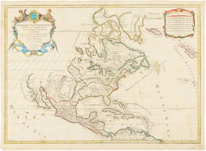
Sold2016Hubert Jaillot. Amerique Septentrionale diviséeHubert Jaillot. Amerique Septentrionale divisée en ses principales parties<See Sold Price
Sold2015Map of North America 1719Heading: (North America) Author: Sanson, Nicolas/ Hubert Jaillot Title: Amerique Septentrionale divisée en ses Principales Parties, ou sont distingués les uns des autres les Estats suivant quils appSee Sold Price
Sold2017Thomson: North America, c 1825Map: North America Maker/Publisher: John Thomson. New General Atlas Date: c. 1825 Medium: Copperplate engraving Description: This map of North America is from some time in the early to mid 1820s. SomeSee Sold Price
Sold2018Map of North America Coloured By Hand 1852 Barbié DeVery beautiful map of North America coloured by hand Author: Barbié de Bocage, Jean-Guillaume (1760 - 1825) Atlas: Atlas Illustre Date: 1852 Technique: etching on steel Leaf Dimension: 25,5x33 cm (10See Sold Price
Sold2023Five Antique Maps, North & South AmericaDescription: Five antique maps including a 1834 Charles Bowen mapof the Great American Eclipse, an unattributed 1825 map of New England, an 1834 Graf & Sorel map of Nunavut, Canada from the exploratioSee Sold Price
Sold2015Pair of Henry Fisher, Hand Colored MapsPublished by Henry Fisher, Caxton London. Each hand colored, one depicting British Dominions m North America, with date of 1823, and the other depicting North America with date of 1825. Each matted anSee Sold Price
Sold2017Edward Wells, map North AmericaEdward Wells, map North America, Edward Wells (British, 1667-1727), "A New Map of North America Shewing its Principal Divisions, Chief Cities, Townes... Dedicated to His Highness William Duke of GloucSee Sold Price
Sold20211752 Four Section Maps North AmericaAll four sections of a wall map of North America arranged for Malachy Postlethwayte for his publication "Dictionary of Trade and Commerce". The maps are based on a work by the French mapmaker D'AnvillSee Sold Price
Sold2020Early Hand Colored Map North America by T ConderAntique framed hand colored early map of North America. Top left image of Native man and foliage, reads "North America agreeable to the most approved Maps and Charts, by Thomas Condor" Frame: 14 3/4 iSee Sold Price
Sold2024de Vaugondy. Nouvel Atlas Portratit de la Geographie Ancienne (Atlas / Map / North America / Southde Vaugondy. Nouvel Atlas Portratit de la Geographie Ancienne (Atlas / Map / North America / South America / DeVaugondy Atlas). Paris: A Paris chez l'Auteur Rue du Foin St. Jacques, 1790. New Edition.See Sold Price
Sold2020L'amerique Septentrionale 1706 Map North AmericaL'amerique Septentrionale 1706 Map Of North America (french). 24 X 20 Inches, Framed.See Sold Price
Sold20191710 SENEX MAP OF NORTH AND CENTRAL AMERICAc. 1710, Map: “NORTH AMERICA,” & “CENTRAL AMERICA,... Corrected from the Observations Communicated to the Royal Society at London And the Royal Academy at Paris,” by John SenexSee Sold Price
Sold2018North America by De L'isleTitle/Content of Map: North America by De L'isle Date Printed: c1730 Cartographer: Guillaume De L'isle Material/Medium: Paper Size: 21" x 25" Provenance: New York Hand colored copperplate engraved. InSee Sold Price
Sold2018NORTH AMERICA.Texas Republic.Mexican California.RussianTITLE/CONTENT OF MAP: 'NORTH AMERICA, South to Panama.' The Republic of Texas is shown as an independent state as it existed between 1836 and 1845; it shows the US-Mexican border prior to the Mexican-See Sold Price
Sold20201761 MAP OF NORTH AMERICA BY ROCQUE18th century map GENERAL MAP OF NORTH AMERICA 1754-1761 by John Rocque, London by A. Drury, 2 part map, 35.5 x 36 inches, good condition.See Sold Price
Sold2021FRAMED J.H. COLTON MAP OF NORTH AMERICA CA INSETFramed engraving on paper, Map of North America from the Latest Authorities, published by J.H. Colton (Joseph Hutchins Colton, 1800-1893), No. 86 Cedar St., New York, 1846, drawn and engraved by J.M.See Sold Price
Sold2024Pownall Map of North America with the West India IslandsPOWNALL, Thomas (1720-1805). A New Map of North America with the West India Islands, divided according to the Preliminary Articles of Peace, Signed at Versailles, 20, jan 1783, wherein are particularlSee Sold Price
Sold2017Levasseur: Antique Map of North America, 1840Title/Content of Map: 1840 Levasseur Map of North America - Amerique Septrentionale Date Printed: 1840 Paris Cartographer: V. Levasseur Size: 11 x 16.5 in. Condition: Excellent. Minor age toning; issuSee Sold Price
May 16Potter & Potter AuctionsSTORM, Mark. Official Texas Brags Map of North America. 194...$200(1 bid)
May 15University ArchivesDeclaration of Independence, Very Early British Publ. in Gentleman's Magazine & Rare Map$1,000
May 15University ArchivesScarce Early Printing: "An Account of the European Settlement in America in 6 Parts..."$100
May 18THOS. CORNELL GALLERIES, LTD.GROUP OF ANTIQUE AND VINTAGE MAPS, INC.. NORTH AND SOUTH AMERICA, WORLD MAPS, LOSSES THROUGHOUT,$100(1 bid)
6 days LeftSchilb Antiquarian Rare Books1869 ATLAS 42 MAPS America Africa Australia GERMANY Switzerland Sydow RARE$155(4 bids)
3 days LeftHunt and Peck Estate Services, Inc.1784 Captain James Cook "A Voyage to the Pacific Ocean" 2 of 3 volumes$360(2 bids)
1 day LeftLunds Auctioneers & Appraisers Ltd.Ducks Unlimited Canada 50th Anniversary "Waterfowl of North America" Folio #10/1250.CA$100(1 bid)