Sold20231839 Russia Map by MoninTitle: 1839 Russia Map by Monin Date/Period: 1839 Materials: Hand colored, engraved Size: 17 1/2” x 12 1/2” 1839. By V. Monin. Paris. Hand-colored, engraved. Good condition, with some foxiSee Sold Price
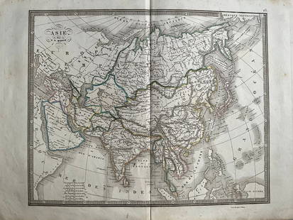
20241839 Asia Map by MoninTitle: 1839 Asia Map by Monin Date/Period: 1839 Materials: Hand colored, engraved Size: 17 1/2 x 12 1/2" This map is an interesting depiction of Asia in 1839 when the continent was still largely unexpSee Sold Price
Sold20241839 Italy Map by MoninTitle: 1839 Italy Map by Monin Date/Period: 1839 Materials: Hand colored, engraved Size: 17 1/2” x 12 1/2” 1839. By V. Monin. Paris. Hand-colored, engraved. Good condition, with some foxinSee Sold Price
Sold20241839 Europe Map by MoninTitle: 1839 Europe Map by Monin Date/Period: 1839 Materials: Hand colored, engraved Size: 17 1/2” x 12 1/2” 1839. By V. Monin. Paris. Hand-colored, engraved. Good condition, with some foxiSee Sold Price
Sold20241839 Known Ancient World Map by MoninTitle: 1839 Known Ancient World Map by Monin Date/Period: 1839 Materials: Hand colored, engraved Size: 17 1/2 x 12 1/2" This map is a fascinating illustration of the world as known to the ancient GreeSee Sold Price
Sold2023Russell & Barclay 1839 Hand Col Map. Russia in EuropeHand Colored Copper Engraved Map Published 1823-40, by Fisher & Son, "A Complete Atlas of the World" by John Russell et al. A Very Rare Work which is compiled from the same plates used in different edSee Sold Price
Sold20241839. Map of Australia and Pacific by MoninTitle: 1839. Map of Australia and Pacific by Monin Date/Period: 1839 Materials: Hand colored, engraved Size: 17 1/2 x 12 1/2" This is a map of Australia and the Pacific in 1839 when the continent wasSee Sold Price
Sold20241839 Map of Netherlands and Belgium by MoninTitle: 1839 Map of Netherlands and Belgium by Monin Date/Period: 1839 Materials: Hand colored, engraved Size: 17 1/2” x 12 1/2” Netherlands and Belgium with Luxembourg. 1839. By V. Monin.See Sold Price
Sold20231839 Map of United Kingdom and Ireland by MoninTitle: 1839 Map of United Kingdom and Ireland by Monin Date/Period: 1839 Materials: Hand colored, engraved Size: 17 1/2” x 12 1/2” 1839. By V. Monin. Paris. Hand-colored, engraved. Good coSee Sold Price
Sold20241839 Map of North America with the Republic of Texas. By MoninTitle: 1839 Map of North America with the Republic of Texas. By Monin Date/Period: 1839 Materials: Hand colored, engraved Size: 17 1/2 x 12 1/2" This map is a stunning representation of North AmericaSee Sold Price
Sold20241839 Map of Norway and Sweden with insert of Iceland by MoninTitle: 1839 Map of Norway and Sweden with insert of Iceland by Monin Date/Period: 1839 Materials: Hand colored, engraved Size: 17 1/2” x 12 1/2” 1839. By V. Monin. Paris. Hand-colored, engSee Sold Price
Sold20241839. Ancient France (Gaul) by MoninTitle: 1839. Ancient France (Gaul) by Monin Date/Period: 1839 Materials: Hand colored, engraved Size: 17 1/2” x 12 1/2” Map of Ancient France, GAUL. 1839. By V. Monin. Paris. Hand-colored,See Sold Price
Sold20241839. World’s Rivers and Mountains By MoninTitle: 1839. World’s Rivers and Mountains By Monin Date/Period: 1839 Materials: Hand colored, engraved Size: 17 1/2 x 12 1/2" This map is a magnificent illustration of the world's mountains andSee Sold Price
Sold20241839 Germany and Central Europe by MoninTitle/Content: 1839 Germany and Central Europe by Monin Date: 1839 Medium: Hand colored, engraved Description: Map of Germany and all of Central Europe. Including the Austrian Empire. 1839. By V. MoniSee Sold Price
Sold20241839 Balkans with Greece. By MoninTitle: 1839 Balkans with Greece. By Monin Date/Period: 1839 Materials: Hand colored, engraved Size: 17 1/2” x 12 1/2” Map of the entire Balkans with a newly independent Greece. 1839. By V.See Sold Price
Sold20241839. Ancient Germania and Central Europe by MoninTitle/Content: 1839. Ancient Germania and Central Europe by Monin Date: 1839 Medium: Hand colored, engraved Dimensions: 17 1/2" x 12 1/2" Description: Map of Ancient tribal Germany and Central Europe.See Sold Price
Sold2017The History of the War with Russia Maps, 1854Map: War with Russia with Tallis Maps,1854 (vol.1.) Cartographer: H Tyrrell and J Tallis Date: 1854 Origin: London Size: 12.8 x 9.6 inches for majority of maps A magnificent book on the War with RussiSee Sold Price
Sold20211839 MAP OF ULSTER COUNTY, NEW YORK, BY DAVID H. BURR,1839 MAP OF ULSTER COUNTY, NEW YORK, BY DAVID H. BURR, STONE & CLARK PUBLISHERS, ITHICA, N.Y. NICELY FRAMED, FROM PROMINENT ELLENVILLE, N.Y. ATTORNEYS OFFICE. MAP MEASURES 22" X 23", NICELY FRAMED, ANSee Sold Price
Sold20201839 Maps, Middle States, Burgess, MitchellTwo hand colored maps, both dated 1839: "Map of the Middle States and part of the Southern, Engraved to Illustrate Mitchells School and family Geography" by S. Augustus Mitchell, engraved by J. H. YouSee Sold Price
Sold20211839 Map of the Southern States, SmithHandsome map drawn and engraved by Stiles, Sherman & Smith to accompany Smith’s Geography for Schools. Shows the entire deep south except for the lower half of Florida. Shows the navigable distanceSee Sold Price
Sold20211855 Russia MapAuthor: Colton Title: 1855 Russia Map Medium: Ink on Paper Dimenions: 15.5"X18.5" Description: Map of Russia dated 1855. Engraved and published by Colton in New York. Key upper left. Detailed. Color cSee Sold Price
Sold20151839 Maps of WisconsinLot of 9, all 6v x 9.5 inch engravings removed from Federal Senate Vol. Vi Continuing Documents, Washington printed by Blair & Rives, 1840. All were engraved by W.J. Stone from maps made by Capt. T.J.See Sold Price
Sold2016Map of Russia 1676, John SpeedFrom the last edition of John Speed's Prospect of the most famous parts of the world published by Bassett and Chiswell after Speed's death. Since this Russia map only appears in the last edition of 16See Sold Price
Sold2020Grp: 6 Maps of SpainGroup of six maps of France and Spain. Includes Friedrich Wilhelm Streit (1772-1839) map of France "Charte von Frankreich nach den besten Hulfsmitteln," Nuremberg, 1815; Guillaume Delisle (1675-1726)See Sold Price
3 days LeftJasper52CAUCASUS. Russia Circassia Astrakhan Georgia Azerbaijan Armenia. LETTS 1883 map$75
3 days LeftJasper52EASTERN EUROPE. Vilna Grodno Volhynia Podoiva Minsk Kiev Smolensk. SDUK 1845 map$35
3 days LeftJasper52Le Nord de l'Europe contenant le Danemark… Scandinavia Russia. BONNE 1780 map$35
4 days LeftHeritage Auctions82153: Konstantin Egorovich Makovsky (Russian, 1839-191$3,000
Jun 07Freeman's | HindmanMURCHISON, Roderick Impey, Sir. The Silurian System. 1839. COMPLETE WITH VERY RARE HAND-COLORED$1,500
3 days LeftJasper52CAUCASUS. 'Georgie Armenie' Georgia Armenia Tblisi Russia. MALLET 1683 old map$100
3 days LeftJasper52Northern States of Europe… Denmark Norway Sweden Russia Prussia. PAAS 1800 map$70