Sold20241839 Map of Netherlands and Belgium by MoninTitle: 1839 Map of Netherlands and Belgium by Monin Date/Period: 1839 Materials: Hand colored, engraved Size: 17 1/2” x 12 1/2” Netherlands and Belgium with Luxembourg. 1839. By V. Monin.See Sold Price
Sold2017Millar: Antique Map Netherlands Belgium Luxenburg, 1768Title/Content of Map: 1768 Millar Map of Netherlands, Belgium, Luxenburg -- A New and Accurate Map of the Seven United Provinces Imcluding the Dutch Netherlands & e. Date Printed: 1768 Cartographer: GSee Sold Price
Sold2019Barclay, James 1809 Antique Map. Netherlands & Belgium"The Seven United Provinces, with The Dutch Possessions in Flanders, Brabant and Limburg" Outline Hand Coloured Copper Engraved Map Published 1809, Leeds for "Barclay's Complete and Universal DictionaSee Sold Price
Sold20191720 Homann Map of Netherlands, Belgium and LuxemburgReserve Reduced! Map Title/Content: 1720 Homann Map of Netherlands, Belgium and Luxemburg -- Tabula Generalis Totius Belgii qua Provinciae XVII. Infer. Germaniae olim sub S.R.I. Circulo Burgundiae…See Sold Price
Sold2018Desnos/de la Tour: Antique Map of Netherlands & BelgiumTITLE/CONTENT OF MAP: 'Les Pays Bas François. Autrichiens, et Hollandois, divisés en Provinces Civiles et Ecclésiastiques. à Paris. Chez le Sr. Desnos. Ingenieur Géographe pour les Globes et Sph�See Sold Price
Sold20201831 Teesdale Map of Netherlands, Belgium andTitle/Content of Map: 1831 Teesdale Map of Netherlands, Belgium and Luxembourg -- Netherlands Date: 1831, London Cartographer: H Teesdale Size: 16.1 X 13.2 in. This is a very nice and detailed map ofSee Sold Price
Sold2018Colton: Antique Map of Netherlands, Belgium, 1859Netherlands, Belgium & Luxembourg with insterst of Brussels & Amsterdam 1859 H.J. Colton 17 1/2" x 15" Hand colored and engraved. Published in New York in Colton's 'General Atlas'. Please note that thSee Sold Price
Sold20241859 Map of Netherlands & Belgium by ColtonTitle: 1859 Map of Netherlands & Belgium by Colton Date/Period: 1859 Materials: Steel engraved Size: 17 1/2 x 14 1/2” Netherlands & Belgium. 1859. By J. H. Colton & G. W. Colton. From "General ASee Sold Price
Sold2019The Netherlands. French-ruled Belgium with 13Reserve Reduced! TITLE/CONTENT OF MAP: 'The Netherlands [Belgium]' Somewhat confusingly entitled "The Netherlands", the map shows the country today known as Belgium. The map is shown as it had been unSee Sold Price
Sold2017Thomson: Map of The Netherlands, 1817Map: 'The Netherlands [Belgium]' Somewhat confusingly entitled "The Netherlands", the map shows the country today known as Belgium. The map is shown as it had been under French rule with 13 DépartemeSee Sold Price
Sold2017Johnston: Map of the Netherlands Belgium LuxemburgMap of Netherlands, Belgium and Luxemburg. The Cabinet Atlas of the World. Johnston, Alexander Keith. This plate: Netherlands, Belgium and Luxemburg. Edinburgh, W. & A.K. Johnston, 1878. Sheet size: 1See Sold Price
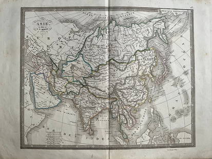
20241839 Asia Map by MoninTitle: 1839 Asia Map by Monin Date/Period: 1839 Materials: Hand colored, engraved Size: 17 1/2 x 12 1/2" This map is an interesting depiction of Asia in 1839 when the continent was still largely unexpSee Sold Price
Sold20241839 Italy Map by MoninTitle: 1839 Italy Map by Monin Date/Period: 1839 Materials: Hand colored, engraved Size: 17 1/2” x 12 1/2” 1839. By V. Monin. Paris. Hand-colored, engraved. Good condition, with some foxinSee Sold Price
Sold20201855 Colton Map of the Netherlands, Belgium andTitle: 1855 Colton Map of the Netherlands, Belgium and Luxembourg -- Holland and Belgium Cartographer: J Colton Year/Place: 1855, New York Dimensions: 14.7 X 12.8 in. Descriptions: This is a very niceSee Sold Price
Sold20231839 Russia Map by MoninTitle: 1839 Russia Map by Monin Date/Period: 1839 Materials: Hand colored, engraved Size: 17 1/2” x 12 1/2” 1839. By V. Monin. Paris. Hand-colored, engraved. Good condition, with some foxiSee Sold Price
Sold20241839 Europe Map by MoninTitle: 1839 Europe Map by Monin Date/Period: 1839 Materials: Hand colored, engraved Size: 17 1/2” x 12 1/2” 1839. By V. Monin. Paris. Hand-colored, engraved. Good condition, with some foxiSee Sold Price
Sold2017Colton: Antique Map of Netherlands and Belgium, 1861Title/Content of Map: Colton's Netherlands and Belgium Date Printed: 1861 Cartographer: J. H. Colton Material/Medium: Paper Size: 17 1/2" x 13 3/4" Hand colored. Steel engraved. From 'Colton's GeneralSee Sold Price
Sold2016Map of The Netherlands, Belgium, and LuxemburgMap of The Netherlands, Belgium, and Luxemburg Maker: Rand, McNally & Co. Date: 1898 From New Standard Atlas of the World Indexed Size: 15 x 21 inches No Reserve: This lot starts at $1 and has no reseSee Sold Price
Sold2019Belgium & Netherlands with sea monsterTitle/Content of Map: Belgium & Netherlands with sea monster Date: 1598/100 Cartographer: By Ruscelli Size: 11x9” Provenance: Venice Additional Info: Geography of Claudius Ptolemy of Alexandria EgSee Sold Price
Sold2018Seutter: Antique Map of Belgium & Netherlands, 1740Title/Content of Map: Belgium & Netherlands or the United 17 Provinces Date Printed: c1740 Cartographer: Matthaus Seutter Material/Medium: Paper Size: 19" x 23" Original hand colored copperplate engraSee Sold Price
Sold2018Stackhouse: Antique Map of Belgium & Netherlands, 1783Title/Content of Map: Belgium & Netherlands or The United Provinces Date Printed: 1783 Cartographer: Thomas Stackhouse Material/Medium: Paper Size: 16" x 20" Original hand color, copperplate engraved.See Sold Price
Sold2018R. Gilles: Antique Map of Belgium & Netherlands, 1750Title/Content of Map: Belgium & Netherlands by R. Gilles Date Printed: c1750 Cartographer: Robert De Gilles Material/Medium: Paper Size: 7 1/2" x 6 2/3" Copperplate engraved from the 'Petit Atlas.' PuSee Sold Price
Sold2022The Netherlands. 1st French Empire Belgium w/ 13 Départements. THOMSON 1830 mapTITLE/CONTENT OF MAP: 'Belgium or the Netherlands' Belgium shown under the First French Empire, with 13 Départements; although Napoleon's rule over the region had ended with his defeat at WaterloSee Sold Price
Sold20241839 Known Ancient World Map by MoninTitle: 1839 Known Ancient World Map by Monin Date/Period: 1839 Materials: Hand colored, engraved Size: 17 1/2 x 12 1/2" This map is a fascinating illustration of the world as known to the ancient GreeSee Sold Price
5 days LeftJasper521792 Elwe Map of the Netherlands and Belgium -- Les Dix-Sept Provinces des Pays-Bas$80
5 days LeftJasper521792 Elwe Map of Southern Netherlands to Belgium to Northern France -- Carte Nouvelle des Pais Bas$80
5 days LeftJasper521579 Ortelius Map of Parts of Belgium and Holland -- Brabantiae, Germaniae Inferioris Nobilissimae$160
May 10Rail & Road Auctions1934 Short Line Motor Coach Service Timetable and 1947 Michelin Map 6 of Netherlands$20
5 days LeftJasper521792 Elwe Map of Holland -- Carte Generale des Provinces Unies des Pais Bas et Terres Voisines?$80


![The Netherlands. French-ruled Belgium with 13: Reserve Reduced! TITLE/CONTENT OF MAP: 'The Netherlands [Belgium]' Somewhat confusingly entitled "The Netherlands", the map shows the country today known as Belgium. The map is shown as it had been un](https://p1.liveauctioneers.com/5584/135277/68682148_1_x.jpg?height=310&quality=70&version=1548808491)
![Thomson: Map of The Netherlands, 1817: Map: 'The Netherlands [Belgium]' Somewhat confusingly entitled "The Netherlands", the map shows the country today known as Belgium. The map is shown as it had been under French rule with 13 Départeme](https://p1.liveauctioneers.com/5584/102391/52309299_1_x.jpg?height=310&quality=70&version=1491597186)