Sold20211857 Map of BaltimoreAuthor: Bradley Title: 1857 Map of Baltimore Medium: Ink on Paper Dimensions: 15"X12" Map of Baltimore dated 1857. Copper plate. Engraved by Joseph Miller. Published by W. Bradley & son. This is one oSee Sold Price
Sold2023AMAZONIA. Showing "El Dorado?", missions & tribes. Brazil Ecuador. SDUK 1857 mapTitle: AMAZONIA. Showing "El Dorado?", missions & tribes. Brazil Ecuador. SDUK 1857 map Description: SOUTH AMERICA, SHEET I., ECUADOR, GRANADA, VENEZUELA AND PARTS OF BRAZIL AND GUYANA' by CartographySee Sold Price
Sold2021GREAT RAILWAY CELEBRATIONS OF 1857 Map B & O,Title: GREAT RAILWAY CELEBRATIONS OF 1857 Map B & O, Author: William Prescott Smith Publishing Info: Appleton Co Edition: First Edition Publishing Date: 1858 Additional Information: Beautiful foldoutSee Sold Price
Sold2023AFRICA pre most European exploration/colonisation. Kong Mountains. SDUK 1857 mapTITLE/CONTENT OF MAP: 'AFRICA' Much of Central Africa was unexplored by Europeans in 1857 and is therefore shown as blank on the map. Lake Victoria was first sighted by a European in 1858. The map shoSee Sold Price
Sold2018U.S Coast Survey 1857 Map. New Orleans, Louisiana"Sketch II Showing The Progress of the Survey in Section No. VIII" A Rare Map centred on New Orleans and Lake Pontchartrain. Also showing Bon Secours Bay (Alabama) Isle au Breton Sound and Vermilion BSee Sold Price
Sold2024AMAZONIA. Showing Indian tribes. Guyana Surinam Brazil. Recife. SDUK 1857 mapTITLE/CONTENT OF MAP: 'SOUTH AMERICA, SHEET II., GUAYANA AND NORTH BRAZIL' The map shows the locations of native Indian tribes DATE PRINTED: 1857 IMAGE SIZE: Approx 35.0 x 42.0cm, 13.75 x 16.5 inchesSee Sold Price
Sold2020Williams & Rapkin 1857 Map of British IndiaSteel Engraved Map Published 1857, London for "England's Battles by Sea and Land..." by Lieut-Colonel Williams. Centre fold as published. Drawn and Engraved by J. Rapkin. Paper Size: 13.75 x 10.5 inchSee Sold Price
Sold2020Williams & Rapkin 1857 Map of Northern IndiaSteel Engraved Map Published 1857, London for "England's Battles by Sea and Land..." by Lieut-Colonel Williams. Centre fold as published. Drawn and Engraved by J. Rapkin. Paper Size: 13.75 x 10.5 inchSee Sold Price
Sold2021Rapkin, John 1857 Map of The Crimea. Ukraine RussiaSteel Engraved Map Published 1857, London for "England's Battles by Sea and Land..." by Lieut-Colonel Williams. Centre fold as issued. Drawn & Engraved by John Rapkin. Paper Size: 14 x 10.5 inch (36 xSee Sold Price
Sold2021Rapkin, John 1857 Map of The Crimea. Ukraine RussiaSteel Engraved Map Published 1857, London for "England's Battles by Sea and Land..." by Lieut-Colonel Williams. Centre fold as issued. Drawn & Engraved by John Rapkin. Paper Size: 14 x 10.5 inch (36 xSee Sold Price
Sold202219TH C. RAILROAD MAP PRINTS - LOT OF 219TH C. RAILROAD MAP PRINTS - LOT OF 2 Lot of 2 railroad map prints, circa 19th century, includes: 1857 Map of the Railroads of the state of New York, drawn by David Vaughan, Lith. C. Van BenthuSee Sold Price
Sold2021Baltimore 1889Title/Content of Map: Baltimore 1889 Date Printed: 1889 Material/Medium: Paper Size: Approx. 10.5x 13.5 inches Additional Info: Crams Indexed Atlas, published by W.H. Stewart, Rochester NY Reserve: $3See Sold Price
Sold20231857 Colton Map of Lake Superior and the Northern Part of Michigan -- Lake Superior and the NorthernTitle: 1857 Colton Map of Lake Superior and the Northern Part of Michigan -- Lake Superior and the Northern Part of Michigan Cartographer: J Colton Year / Place: 1857, New York Map Dimension (in.): 11See Sold Price
Sold20191857 Colton Map of Lake Superior and the Northern PartReserve Reduced! Title/Content of Map: 1857 Colton Map of Lake Superior and the Northern Part of Michigan -- Lake Superior and the Northern Part of Michigan Date: 1857, New York Cartographer: J ColtonSee Sold Price
Sold2017Vidal/Hydrographic Office: Islands of Madeira Map, 1857Map: The Islands of Madeira Porto Santo and Dezertas Cartographer: Vidal/Hydrographic Office of the Admiralty Place & Date: London / 1857 Size: 30 1/4" x 25 7/8" A large and dramatically detailed topoSee Sold Price
Sold20211857 Colton Map of Kansas and Nebraska -- Kansas andTitle: 1857 Colton Map of Kansas and Nebraska -- Kansas and Nebraska Cartographer: J Colton Year / Place: 1857, New York Map Dimension (in.): 24.5 X 15. 9 in. This is an outstanding Colton map. It shoSee Sold Price
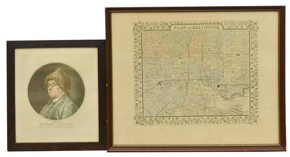
Sold2020(2) BEN FRANKLIN RUOTTE & BALTIMORE MAP ENGRAVINGS(lot of 2) Framed engravings on paper, including: (1) Benjamin Franklin (American, 1706-1790), after the original drawing by Charles Nicolas Cochin II (French, 1715-1790), engraved by C. Ruotte (LouisSee Sold Price
Sold20201857 Colton Map of the Caribbean / West Indies -- WestTitle/Content of Map: 1857 Colton Map of the Caribbean / West Indies -- West Indies Cartographer: J Colton Year/Place: 1857, New York Size: 11.6 X 14.6 in. This is a very nice engraved map of the CariSee Sold Price
Sold20221856 Chart of The Hudson River from Albany to New Baltimore -- Map of Comparison of Hudson RiverTitle: 1856 Chart of The Hudson River from Albany to New Baltimore -- Map of Comparison of Hudson River from Albany to New Baltimore Cartographer: US Coast Survey Year / Place: 1856 Map Dimension (in.See Sold Price
Sold2023Excellent 1860 map of Baltimore by Samuel A. Mitchell, Jr.Nice example of Samuel Augustus Mitchell Jr’s map of Baltimore with the vivid outline hand coloring that sets this edition off from other editions. Shows wonderful detail at the street level, inSee Sold Price
Sold20191860 Mitchell Map of Baltimore -- Plan of BaltimoreTitle: 1860 Mitchell Map of Baltimore -- Plan of Baltimore Date: 1860, Philadelphia Cartographer: S Mitchell Size: 9 X 11.2 in. Additional Information: A very nice map of Baltimore, identifying the vaSee Sold Price
Sold20191857 Colton Map of Australia -- AustraliaReserve Reduced! Title/Content of Map: 1857 Colton Map of Australia -- Australia Date: 1855, New York Cartographer: J Colton Size: 12.5 X 14.6 in. This is a very nice map of Australia. The counties arSee Sold Price
Sold20191857 Colton Map of Mexico -- MexicoTitle/Content of Map: 1857 Colton Map of Mexico -- Mexico Date: 1855, New York Cartographer: J Colton Size: 11.8 X 14.7 in. This is a very nice map of Mexico. It includes the Baja, most of Texas and pSee Sold Price
Sold2017J. H. Colton: Palestine Map, 1857Palestine, 14 x 17 in, 1857, J. H. Colton Please note that this lot has a confidential reserve. When you leave a bid in advance of the auction, submit your maximum. Jasper52 will bid on your behalf asSee Sold Price
Featured7 hrs LeftJasper52Johnson's New Military Map of the United States Showing the Forts, Military Posts &C. With Enlarged$65
21 hrs LeftThomaston Place Auction Galleries1857 KANSAS & NEBRASKA HANDBOOK BOUND WITH LIFE OF GEN JOSEPH WARREN$100
Jun 06Freeman's | HindmanCONRAD, Joseph (1857-1924). Victory. An Island Tale. Garden City, NY: Doubleday, Page & Company,$1,000
May 30Forum AuctionsIndia.- Revolt in Central India 1857-59 (The): compiled in the Intelligence Branch Division of the£500
May 29Cedarburg Auction & Appraisals LLCSet of Four Maps Showing All of Spain and Portugal$375(2 bids)