Sold20201858 Map of Minnesota and DakotaAuthor: Johnson Title: 1858 Map of Minnesota and Dakota Medium: Ink on Paper Dimensions: 18"X14.5" Map of Minnesota and Dakota dated 1858. Engraved by A.J. Johnson. Published by Johnson and Ward in NeSee Sold Price
Sold2019Minnesota, Dakota’sTitle/Content of Map: Minnesota, Dakota’s Date: 1863 Cartographer: By Johnson & Ward. From, Johnson’s New Illustrated Family Atlas Size: 18x14” Provenance: New York Additional Info: Hand coloredSee Sold Price
Sold2018Colton: Antique Map of Minnesota & Dakota, 1859Title/Content of Map: Minnesota & Dakota by Colton Date Printed: 1859 Cartographer: H.J. Colton Material/Medium: Paper Size: 17 1/4" X 15" Hand colored,engraved. Published in New York in 'Colton's GenSee Sold Price
Sold2022Johnson’s Minnesota and Dakota, 1862Great steel engraved map of Minnesota and Dakota Territory. Very good color and impression. Fully hand colored. From the 1862 Johnson's New Illustrated (Steel Plate) Family Atlas. Small edge tear (arcSee Sold Price
Sold20201855 Colton Map of Minnesota and the Dakotas --Title: 1855 Colton Map of Minnesota and the Dakotas -- Minnesota Cartographer: J Colton Year/Place: 1855, New York Size: 11.8 X 15.7 in. Description: This is an excellent map of Minnesota and the emerSee Sold Price
Sold20191855 Colton Map of Minnesota and the Dakotas --Reserve Reduced! Title/Content of Map: 1855 Colton Map of Minnesota and the Dakotas -- Minnesota Date: 1855, New York Cartographer: J Colton Size: 11.8 X 15.7 in. This is an excellent map of MinnesotaSee Sold Price
Sold20201860 Mitchell Map of Minnesota and the DakotasTitle/Content of Map: 1860 Mitchell Map of Minnesota and the Dakotas --Minnesota and Dacotah Date: 1860, Philadelphia Cartographer: S Mitchell Size: 10.6 X 13.3 in. This is a rather nice map of MinnesSee Sold Price
Sold2017Young: Map of Minnesota Territory, 1850Map: Map of Minnesota Territory Maker: J. H. Young Publisher: Cowperthwait, DeSilver & Butler Publishing Date: 1850 (1854) "Important early map of Minnesota Territory, including all of Dakota, from thSee Sold Price
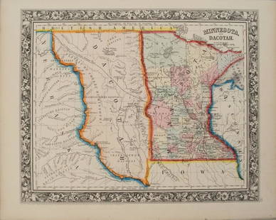
Sold20231859. Minnesota & Dakota territory. By Colton>Title: 1859. Minnesota & Dakota territory. By Colton Date/Period: 1859 Materials: Steel engraved Size: 17 1/2 x 14 1/2” Minnesota and Dakota territory. Important map in the settlement of the regionSee Sold Price
Sold2020Johnson’s Minnesota & Dakota, 1863Clean and beautifully centered, this map of Minnesota and the eastern portion of Dakota territory comes from an early 1863 edition of Johnson’s Family Atlas. Later 1863 editions of the map feature aSee Sold Price
Sold2021Nice 1862 map of Minnesota by MitchellMap of Minnesota at the time of the Dakota War of 1862. In August of that year, along the Minnesota River in the southwestern part of the state, the Dakota tribe began attacking settlers due to the haSee Sold Price
Sold20221868 1ed Dakota Land History INDIANS Minnesota Wisconsin Michigan MAP Hankins1868 1ed Dakota Land History INDIANS Minnesota Wisconsin Michigan MAP Hankins Colonel Hankins Dakota Land is a fascinating post-Civil War survey of the geography and history of Minnesota, Wisconsin, aSee Sold Price
Sold20231864 Johnson Map of Dakota Territory and Minnesota -- Johnson's Minnesota and DakotaTitle: 1864 Johnson Map of Dakota Territory and Minnesota -- Johnson's Minnesota and Dakota Cartographer: Johnson & Ward Year / Place: 1864, New York Map Dimension (in.): 12.5 x 15.9 in. This is a verSee Sold Price
Sold20181864 Johnson Map of Dakota Territory and MinnesotaTitle/Content of Map: 1864 Johnson Map of Dakota Territory and Minnesota -- Johnson's Minnesota and Dakota Date Printed: 1864, New York Cartographer: Johnson & Ward Size: 12.5 x 15.6 in. This is an inSee Sold Price
Sold20201861 Johnson Map of Dakota Territory and Minnesota --Title/Content of Map: 1861 Johnson Map of Dakota Territory and Minnesota -- Johnson's Minnesota and Dakota Cartographer: Johnson & Ward Year/Place: 1861, New York Size: 12.5 x 15.9 in. This is an inteSee Sold Price
Sold20241863 Johnson Map of Dakota Territory and Minnesota -- Johnson's Minnesota and DakotaDescriptionTitle: 1863 Johnson Map of Dakota Territory and Minnesota -- Johnson's Minnesota and DakotaCartographer: Johnson & WardYear / Place: 1863, New YorkMap Dimension (in.): 12.5 x 15.9 in.This iSee Sold Price
Sold2022Scarce 1855 Minnesota from Colton’s Atlas of the WorldImportant early atlas map of Minnesota Territory, immediately after the creation of Dakota Territory. This map appeared in the 1856 Colton 2-volume Atlas of the World. Map is by Johnson & Browning. ItSee Sold Price
Sold2020Johnson's Minnesota and DakotaTitle: Johnson's Minnesota and Dakota Prublication Date: 1862 Cartographer: JOHNSON AND WARD Publisher: JOHNSON AND WARD Size: 11.2Height - 14Width Additional Information: Map showing counties (in MNSee Sold Price
Sold20201869 Mitchell Map of Plains States and Colorado --Title/Content of Map: 1869 Mitchell Map of Plains States and Colorado -- XVIII Kansas, Colorado, New Mexico and Indian Territory [verso] XVI Minnesota and Dakota [also] XVII Nebraska Cartographer: S MSee Sold Price
Sold20231861 Large Dakota Territory with Minnesota. By Johnson and Browning>Title: 1861 Large Dakota Territory with Minnesota. By Johnson and Browning Date/Period: 1861 Materials: Steel engraved Size: 18x13? Important map especially for the Dakota area. 1861, by Johnson andSee Sold Price
Sold2018Tallis/Rapkin: Antique Map of the United States, 1851TITLE/CONTENT OF MAP: 'United States' The map shows 30 of the then 31 states of the United States (the other being California), plus Minnesota territory (which became the 32nd state in 1858), and NebrSee Sold Price
Sold2017Tallis/Rapkin: Antique Map of North America, 1849Title/Content of Map: 'North America' The map shows the then 30 states of the United States, plus Minnesota territory (which became the 32nd state in 1858), Nebraska Territory (eventually divided betwSee Sold Price
Sold2018NORTH AMERICA. 31 US states. Texas with RepublicTITLE/CONTENT OF MAP: 'North America' The map shows the then 31 states of the United States, plus Minnesota territory (which became the 32nd state in 1858), Nebraska Territory (eventually divided betwSee Sold Price
Sold2021US Handkerchief - 32 Stars (1858) Minnesota Union -US Handkerchief - 32 Stars (1858) Minnesota Union MAY 11 1858. 32 STARS - 9 MONTHS LATER OREGON JOINED THE UNION. Frame 19" x 19" Print Size 11" x 11" Condition: EXC Reserve: $320.00 Shipping:<See Sold Price
May 16Eldred'sFREDERIC SCHILLER COZZENS' INVITATION TO PARTICIPATE IN THE COLUMBIA RIVER HISTORICAL EXPEDITION$50(1 bid)
4 days LeftRail & Road Auctions1915 Great Northern Railway Special Menu - Annual Trade Tour of the St. Paul Association of Commerce$20


![1869 Mitchell Map of Plains States and Colorado --: Title/Content of Map: 1869 Mitchell Map of Plains States and Colorado -- XVIII Kansas, Colorado, New Mexico and Indian Territory [verso] XVI Minnesota and Dakota [also] XVII Nebraska Cartographer: S M](https://p1.liveauctioneers.com/5584/179983/90569362_1_x.jpg?height=310&quality=70&version=1601417445)


