Sold2018Framed Antique U.S. MapsFramed Antique Maps of U.S. and Eastern United States. To 23" x 18".See Sold Price
Sold20241840 Virtue/Willis Map of Northeast US -- The North Eastern Part of the United StatesTitle: 1840 Virtue/Willis Map of Northeast US -- The North Eastern Part of the United States Cartographer: W Hughes Year / Place: 1840 in Old Maps as Virtue Map Dimension (in.): 7.7 x 10.8 in. This isSee Sold Price
Sold2017William Faden 1796 Map Eastern US, North AmericaFaden, William (BRITISH, 1749-1836); Map of the Eastern United States, North American with British Territories and Those of Spain according to the Treaty of 1784 (from a larger atlas), 1796; handcolorSee Sold Price
Sold2021MAP, Eastern US, Phelps & EnsignEastern United States. Phelps & Ensign, Phelps & Ensign's Travellers' Guide, and Map of the United States, Containing the Roads, Distances, Steam Boat and Canal Routes &c., 1842 (dated). Hand Color. TSee Sold Price
Sold2019MAP - Eastern US. AnonymousColonial Eastern United States. Anonymous, An Accurate Map of the English Colonies in North America Bordering on the River Ohio, 1754 (published). Hand Color. This unusual map of the colonies spans frSee Sold Price
Sold2023MAP, Eastern US, BowenColonial Eastern United States. Emanuel Bowen, A Map of the British American Plantations, Extending from Boston in New England to Georgia; Including All the Back Settlements in the Respective ProvinceSee Sold Price
Sold2023Framed Engraved Map of Eastern US by E. Jones 1805Featured in this lot is this original 1805 E. Jones engraved map showing the United States from Maine to Georgia (Florida is cut off) and west to the Mississippi. The map was engraved by E. Jones, andSee Sold Price
Sold2021WILLIAM MACKENZIE Map of Eastern US LithographWILLIAM MACKENZIE Map of Eastern US Lithograph, inscriptions read ‘Eastern Division of the United States’, ‘William Mackenzie London Edinburgh & Glasglow’, subject the eastern United States, mSee Sold Price
Sold2018Rand McNally: Antique US Population Trend Map, 1892Title/Content of Map: 1892 Rand McNally US Population Trend Map -- Rand McNally & Co.'s Map of the United States Showing the Increase and Decrease of Population 1880 to 1890 Date Printed: 1892, ChicagSee Sold Price
Sold20211876 RR map - NE U.S. in uncommon formatLarge and uncommon map of the upper eastern seaboard of the United States in an unusual layout. From the very scarce 1876 Jones and Hamilton Historical Atlas of the World Illustrated. Clean and soundSee Sold Price
Sold2019U S Coast Survey 1896 LG Map. New Orleans Texas Florida"Sketch of General Progress June 30. 1896" Showing Southern, Eastern and Mid West States, incl Florida, Texas, Gulf of Mexico, Georgia etc. Large Lithograph Map Published 1896, Washington for "U.S. CoSee Sold Price
Sold2020Grp: Books on the Eastern U.S.Group of books and maps on the Eastern United States. Includes The John Henry County Map of Virginia 1770 by Louis B. Wright (two copies); Tidewater Towns: City Planning in Colonial Virginia and MarylSee Sold Price
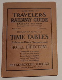
Sold20241915 Traveler's Guide Eastern US. A 344 page bookA 5 3/4" by 8" soft cover book with railroad timetables and other travel information: hotel ads, city, state maps, etc. Paper is supple and not pulpy.See Sold Price
Sold2023MAP: United States - East Coast. Connecticut - New York. Long Island Sound - Eastern PartDescription: United States - East Coast. . Connecticut - New York. Long Island Sound - Eastern Part. Published at Washington D.C. US Department of Commerce, Environmental Science services AdministratiSee Sold Price
Sold2018Map of Eastern States With Part of Canada, 1814Title/Content of Map: Eastern States With Part of Canada Date Printed: 1814 ca. Cartographer: ANONYMOUS Size (inches): 22.75x20.25 Simple map, with some topography. Modern color. Please note that thisSee Sold Price
Sold2020GEORGIA & Southern Appalachia. Alabama Tennessee NC SCTITLE/CONTENT OF MAP: 'Eastern United States No 8' DATE PRINTED: 1883 IMAGE SIZE: Approx 44.0 x 35.5cm, 17.25 x 14 inches (Large); Please note that this is a folding map. TYPE: Antique colour atlas maSee Sold Price
Sold20181798 Stockdale Map of Eastern United StatesTitle/Content of Map: 1798 Stockdale Map of Eastern United States -- Part of the United States of North America Date Printed: 1798 London Cartographer: J. Stockdale Size: 18.4 x 16.2 in. This antiqueSee Sold Price
Sold20211812 Map of US Southern StatesAuthor: Shall Title: 1812 Map of US Southern States Medium: Ink on Paper Dimensions: 16"X10.5" Map of the US Southern states dated 1812. Engraved by Shall on hand laid cotton paper. Published by AndreSee Sold Price
Sold2024Vintage Framed Map of Eastern United StatesVintage Framed Map of Eastern United States. size: 15 x 18.5 matte, 21.5 x 25 outside frameSee Sold Price
Sold2020Six Nations New York Map and North Eastern States MapItems as shown. Framed 20x15 & 18x14See Sold Price
Sold2023Map No. 2 Eastern StatesPublication Date: 1844 Title: Map No. 2 Eastern States Cartographer: SHERMAN/SMITH Publisher: DANIEL BURGESS & CO. Height: 8.5 Width: 11.25 "Designed to accompany Smith's Geography for Schools" Map shSee Sold Price
Sold2019Colton's Arkansas. Decorative antique US state map 1863TITLE OF MAP (NOT PRINTED ON THE PAGE):'Colton's Arkansas' DATE PRINTED: 1863 IMAGE SIZE: Approx 34.0 x 41.5cm, 13.25 x 16.25 inches (Large) TYPE: Antique engraved hand coloured atlas map CONDITION: GSee Sold Price
Sold20241869 American Emigrants Immigration Illustrated US State MAPS Railroad Alaska1869 American Emigrants Immigration Illustrated US State MAPS Railroad Alaska Frederick Goddards “Where to Emigrate and Why” is a rare, 19th-century informational treatise designed to give hinSee Sold Price
Sold2020US State Maps 1903 Lot of 6. Illinois, Ohio, MichiganAlso Indiana. Lithograph Maps Published 1903 by Adam & Charles Black, Edinburgh & London for "Encyclopaedia Brittannica" Tenth Edition. Centre fold as published. Paper Size: 16 x 11.5 inch (41 x 29cm)See Sold Price
10 hrs LeftJasper52Amér Sep Partie de… Vieille Californie #53 Baja California VANDERMAELEN 1827 map$260
Oct 18Rail & Road Auctions1878 Maps of the New and Popular St. Louis and Texas Short Line Railroad Color Lithograph$40(1 bid)
10 hrs LeftJasper52United States of America. California Gold region. THOMAS, COWPERTHWAIT 1852 map$380
10 hrs LeftJasper52Large Civil War map of the United States. ETTLING. Illustrated London News 1861$300
Oct 12JM Hobby Supply and Railroad Artifact AuctionsUS Railroad Association-1918 North Dakota Agricultural Brochure$30
Oct 13Austin Auction GalleryESTATE US LIBERTY EAGLE $10 GOLD COIN PENDANT ON 14KT CHAIN NECKLACE$1,500
10 hrs LeftJasper52Terrae Novae / Terra Nova by Bertius / Langenes. Newfoundland, Canada 1603 map$500
10 hrs LeftJasper52Amér. Sep. Parties des États-Unis #49. Missouri Illinois. VANDERMAELEN 1827 map$260