Sold2021Antique 18th C Map, England, Johann Baptist HomannOriginal decorative copperplate engraving on hand-laid paper with strike impression, map of England and Wales in full wash color, cartouche with title, two coats of arms and vignette, titled "Magnae BSee Sold Price
Sold2021Homann 1736 Map of Portugal"Regnum Portugalliae Divisum in Quinque Provincais majores & Subdivisum in sua quaeque Territoria una cum Regna Algarbiae." 18th century map by Johann Baptist Homann with fully engraved mountains, forSee Sold Price
Sold2017J.B. Homann, 18th c. map of IrelandJ.B. Homann, 18th c. map of Ireland, Johann Baptist Homann (German,1664-1724), "Hiberniae Regnum tam in Praecipuas Ultoniae, Connaciae, Laceniae et Momoniae quam in Minores", c. 1720, 24"h x 20.5"w (sSee Sold Price
Sold2017J.B. Homann, 18th c. map of SaxonyJ.B. Homann, 18th c. map of Saxony, Johann Baptist Homann (German,1664-1724), "Circulus Saxoniae inferioris", c. 1740, including Bremen, Berlin, and Lübeck, 20.75"h x 24.5"w (sheet), unframed ProveSee Sold Price
Sold2023"Regni Daniae" Antique 18thC Hand Colored Map of Denmark by Johann Baptiste Homann"Regni Daniae" Antique 18thC Hand Colored Map of Denmark by Johann Baptiste Homann. Frame Size: 21 3/4" H x 25 1/4" W x .75" D. Sight Size: 20" H x 23 1/2" W.See Sold Price
Sold2024Exceptional 18th Century Map of The Carolinas, Maryland and VirginiaBy Johann Baptist Homann, Germany, late 17th/early 18th century. Hand colored map of the region which is excellent and quite rare. The map giving excellent details of the region and having exquisite eSee Sold Price
Sold202018TH C MAP OF DENMARK, IN SEE THROUGH FRAME, NICE18TH C MAP OF DENMARK, IN SEE THROUGH FRAME, NICE OVERALL CONDITION, WITH SOME HAND COLORING. MEASURES 19 1/4" X 22 1/4?". FROM LOCAL ESTATE. JOHANN BAPTIST HOMANN (EDITOR), JOHANN HUBNER (CARTOGRAPHYSee Sold Price
Sold2020Grp: 7 Maps of Sicily and Sardinia ItalyGroup of seven maps of Sicily and Sardinia, Italy. Early 18th century Johann Homann (1664-1724) map "Regnorum Sicilia et Sardinia;" 18th century Homann Heirs map of Sicily "Regni & Insulae Siciliae TaSee Sold Price
Sold2023Atq JOHAN HOMANN Peru & Brazil Cartographic MapAntique circa first half of 18th century cartographic map of Peru and Brazil. Maker Homanianos Heredes (Johann Homann). Reads: Tabula America Specilialis Geographica Regni Peru, Brasilia Terra Firma.See Sold Price
Sold20241720 antique MAP of GERMANY 18th CENTURY Lower Saxony & North Rhine-WestphaliaCirculi Westphaliae in omnes suos Status et Provincias… 18th century coloured map of Lower Saxony and North Rhine-Westphalia by by Johann Baptist Homann. Shows the area between Hamburg, Cologne, OldSee Sold Price
Sold20231743 antique MAP of SWABIA GERMANY 18th CENTURY CIRCULI SVEVIAECIRCULI SVEVIAE by Homann, Johann Baptist, 1663-1724 Nuremberg, 1743 Size 20 by 23" Some wear, small repairs and damages at the margins, some faded dampstains The Homann family was the most importantSee Sold Price
Sold20231742 antique MAP of ITALY ITALIA IN FUOS STATUS 18th CENTURYITALIA IN FUOS STATUS Status divisa et ex prototypo del Isliano by Homann, Johann Baptist, 1663-1724 Nuremberg, 1742 size 20.5 by 25" Good condition, some wear, trimmed lower margin Reserve: $140.00 SSee Sold Price
Sold20231741 antique MAP OF FRANCE REGNI GALLIEAE SEU FRANCIAE et Navarrae Tabula 18th CREGNI GALLIEAE SEU FRANCIAE et Navarrae Tabula Geographicea by Homann, Johann Baptist, 1663-1724 Nuremberg, 1741 size 20.5 by 24.5" Wear , damaged lower margin, as visible on the photos Reserve: $105.See Sold Price
Sold2018ANTONIO ZATTA (ITALIAN, 18TH CENTURY) MAP / ATLAS OFANTONIO ZATTA (ITALIAN, 18TH CENTURY) MAP / ATLAS OF NORTH AMERICA, SET OF 12, hand-colored, on laid paper, comprising title page lettered in part "LE / COLONIE UNITE / DELL' / AMERICA SETTENTR'LE." aSee Sold Price
Sold2023Atlas Historique Map of Spain & PortugalAn early 18th century Atlas Historique engraved map of Spain and Portugal. Titled "Carte Historique et Geographique des Royaumes d Espagne et de Portugal". Minor toning, very slight foxing. Image 22 xSee Sold Price
Sold2024Johann Homann Hand-Colored Map Engraving, c. 1730Johann Baptist Homann (German, 1664-1724), Generalis Totius Imperii Russorum, Hand-Colored Engraving, printed circa 1730, painted red frame. Image: 20" H x 23" W; frame: 27" H x 33" W. Provenance: ProSee Sold Price
Sold20241720 Tabula Geographica Homann Map of Black Sea18th Century 1720 Tabula Geographica Homann Map of Black Sea - Tabula Geographica qua pars Russiae Magnae Pontus Euxinus seu Mare Nigrum et Tartaria Minor cum finitimis Bulgariae, et Romaniae et NatolSee Sold Price
Sold2017Phaenomena Motuum Irregularium, celestial mapPhaenomena Motuum Irregularium, celestial map, 18th c., Doppelmayr/Homann, each sheet: 19"h x 22.5"w (sight), 43.5"h x 26.75"w (framed ensuite) Provenance: Property from a New York Corporate CollectioSee Sold Price
Sold20191800 Geography ATLAS MAPS John Walker India Asia World1800 Geography ATLAS MAPS John Walker India Asia World Map John Walker’s ‘Elements of Geography’ is an incredibly late 18th-century English atlas known for its impressive folding maps. This atlaSee Sold Price
Sold2019Pomerania Central Europe Antique MapDucatus Pomeraniae. Hand-colored engraved map. J.B. Homann, Nuremberg, 18th C.. 21" x 24".See Sold Price
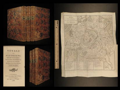
Sold20221788 Voyages Germany MAP Johann Riesbeck Letters Munich Vienna Austria 3v SET1788 Voyages Germany MAP Johann Riesbeck Letters Munich Vienna Austria 3v SET Johann Kaspar Riesbeck was a 18th-century German travel writer best-known for his book Letters from a French traveler in GSee Sold Price
Sold20221720 antique MAP of HUNGARY TRANSYLVANIA ROMANIA 18th CENTURYRegni Hungariae tabula generalis ex archetypo Mülleriano S.C.M. capit. et ing. desumta et in hanc formam contracta viis veredariis aucta novissimaeque pacis Passarovicensis confiniis illustrata /See Sold Price
Sold2016FRENCH 18TH CENTURY ATLAS GENERAL(65) colored maps Overall- 12 3/4" x 17" Condition- some condition, lossesSee Sold Price
Sold20221782 ATLAS MAPS Expilly Geography Voyages Travel World America Asia Africa1782 ATLAS MAPS Expilly Geography Voyages Travel World America Asia Africa Jean-Joseph Expilly was an 18th-century French geography and historian who published numerous works on cosmography, history oSee Sold Price
May 05Tremont Auctions18th century map "Americae Septentrion" by Homann. Rarer early edition. Framed. Holes around outer$250(1 bid)
May 14Fleischer's Auctions1755 Map Partie de l'Amerique Septentrionale, qui comprend Le Cours de L'Ohio...$200(3 bids)
May 05Tremont Auctions18th century map of New Jersey. "A New and Accurate Map of New Jersey". W. Long, London. Map size 13$100
May 09Hunt and Peck Estate Services, Inc.ANTONIO ZATTA (ITALIAN, 18TH CENTURY) MAP OF VIRGINIA$80(2 bids)
May 09Hunt and Peck Estate Services, Inc.ANTONIO ZATTA (ITALIAN, 18TH CENTURY) MAP OF VIRGINIA$70(1 bid)
May 05Tremont Auctions18th century original map of South America. "Charles Earl of Sunderland and Baron Spencer. This Map$150(1 bid)
4 days LeftJasper52Entrée de Norton & Détroit de Bhering. Bering Strait Norton Sound BONNE 1790 map$30
Featured4 days LeftJasper52Entrée de Norton & Détroit de Bhering. Bering Strait Norton Sound BONNE 1788 map$30
4 days LeftJasper52Isles de la Reine Charlotte. Nendo, Santa Cruz, Solomon Islands. BONNE 1790 map$20
4 days LeftJasper52Isles de la Reine Charlotte. Nendo, Santa Cruz, Solomon Islands. BONNE 1788 map$20
4 days LeftJasper52Isles de la Société. Society Islands. Huaheine Raiatea Polynesia. BONNE 1788 map$35
3 days LeftJasper521719 Chatelain Map of Russian Empire -- Carte Generale des Etats du Czar Empereur de Moscovie?$320
3 days LeftAdam's AuctioneersCONTINENTAL SCHOOL (18th CENTURY) After HENRY ROBERT MORLAND The Unlucky Boy Oil on panel, 26.5 x€240
May 07Hermann Historica GmbHAn Austro-Hungarian sabre for officers of the Hussars, 18th century€3,000