Sold202218TH-CENTURY MAP OF AFRICA18TH-CENTURY MAP OF AFRICA: John Senex "Africa Corrected from the Observations of the Royal Society of London and Paris", published 1714. Frame Approx. 29.25" h x 40.25" w.See Sold Price
Sold202117TH / 18TH CENTURY MAP "ANTIENT AFRICA"Hand colored engraving with center fold. Titled "A New Map of The North Part of Antient Africa." Dimensions: (Frame) H 22" x W 26.5" (Sight) H 15" x W 19.5" Condition: Paper clean.See Sold Price
Sold202318th Century Map Of Southern Africa & The Congo18th Century Map Of Southern Africa & The Congo. Titled "Carte du Royaume de Congo, du Monomotapa et de la Cafrerie. Dressee sur les Memoires les plus exacts & les observations les plus Nouvelles.// MSee Sold Price
Sold202318th Century English Engraved Map of AfricaBy T. Jefferies circa 1748. Nicely detailed map of Africa and its regions. Some yellowing and slight loss at the edges. H9 3/4" W11 1/4"See Sold Price
Sold2021"AFRICA", map belonging to the "Atlas Universel,"AFRICA", map belonging to the "Atlas Universel, dressé sur les meilleures cartes modernes", second half of the 18th century.Illuminated engraving (colour demarcations).Edition M. Remondini, VeniceSee Sold Price
Sold20181759 Barrow Geography Dictionary ATLAS MAPS Syria1759 Barrow Geography Dictionary ATLAS MAPS Syria Africa Coffee Tobacco HUGE FOLIO John Barrow was an 18th-century English naval historian remembered for his illustrated dictionaries. This tome from BSee Sold Price
Sold20191799 Voyages in Syria & EGYPT Africa Illustrated MAPS1799 Voyages in Syria & EGYPT Africa Illustrated MAPS Sphinx Pyramids 2v Volney Constantin-François Volney, an 18th-century French philosopher known for his historical works on archaeology and travelSee Sold Price
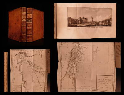
Sold20201787 1st ed Voyages in Syria & EGYPT Africa Illustrated1787 1st ed Voyages in Syria & EGYPT Africa Illustrated MAPS Sphinx 2v Volney “The best expose of Ottoman Empire at the end of the 18th-century!” (Blackmer) Constantin-François Volney, an 18th-ceSee Sold Price
Sold20221751 ATLAS Geography MAPS South America USA Asia Africa Universal Gazetteer1751 ATLAS Geography MAPS South America USA Asia Africa Universal Gazetteer John Walkers Universal Gazetteer is a late 18th-century geographical dictionary and atlas filled with descriptions of countlSee Sold Price
Sold20181828 ATLAS MAPS Ancient & Modern Geography Asia Africa1828 ATLAS MAPS Ancient & Modern Geography Asia Africa Turkey Greece Delamarche Felix Delamarche was a well-known and important French cartographer from the 18th-century. His best and most widely usedSee Sold Price
Sold20231847 ATLAS 37 MAPS Geography Alexander the Great America Africa Delamarche1847 ATLAS 37 MAPS Geography Alexander the Great America Africa Delamarche Felix Delamarche was a well-known and important French cartographer from the 18th-century. This 1847 French atlas was publishSee Sold Price
Sold20211776 1ed History of Loango AFRICA Proyart Kakongo Congo1776 1ed History of Loango AFRICA Proyart Kakongo Congo Missionaries HUGE MAP Lievain Proyart was an 18th-century French author mostly known for his treatises on the Catholic Church. However, his mostSee Sold Price
Sold20221782 ATLAS MAPS Expilly Geography Voyages Travel World America Asia Africa1782 ATLAS MAPS Expilly Geography Voyages Travel World America Asia Africa Jean-Joseph Expilly was an 18th-century French geography and historian who published numerous works on cosmography, history oSee Sold Price
Sold20221777 ATLAS MAPS Expilly Geography Voyages Travel World America Asia Africa1777 ATLAS MAPS Expilly Geography Voyages Travel World America Asia Africa Jean-Joseph Expilly was an 18th-century French geography and historian who published numerous works on cosmography, history oSee Sold Price
Sold20231761 ATLAS MAPS Expilly Geography Voyages Travel World America Asia Africa1761 ATLAS MAPS Expilly Geography Voyages Travel World America Asia Africa Jean-Joseph Expilly was an 18th-century French geography and historian who published numerous works on cosmography, history oSee Sold Price
Sold20171789 Vaugondy MAPS Geography Atlas Asia1789 Vaugondy MAPS Geography Atlas Asia Spain TURKEY Greece America Africa This fascinating 18th-century geography book is a necessary inclusion in any geographical library. When browsing catalogs andSee Sold Price
Sold201618th C. map of BermudaCarte des Isles Bermudes ou de Sommer, Paris 1764. Hand colored copperplate engraving From Bellin's Petit atlas maritime.Tome I N.48 Plate XXXIII. Frame under glass, not inspected out of the frame. 8"See Sold Price
Sold202318th C Map of Lake Route Montreal to Hudson River1782 Map of the lake route from Montreal and St. Jean to the Hudson River : Carte de la route des lacs depuis Montreal et St. Jean jusqu'a la Riviere d'Hudson : reduite d'apres les meilleures cartes aSee Sold Price
Sold2017Large and impressive 18th C. map of the Empire of JapanA large and impressive map of the Empire of Japan, by Mattheus Seuter, Amsterdam, 1720-1740. The title: Empire of Japan in 66 Regions. The land areas fully colored, but title cartouche to Benjamin DutSee Sold Price
Sold2024EARLY 18TH C. MAP OF ITALY, FRAMED"Italia iam Tota Principes in suas Partes accuratius distincta hisee, praeter caeteras adjunximus Majerum ejus Insularum Siciliam . . .", by Peter Schenk, Amsterdam, ca 1700, handcolored copperplate eSee Sold Price
Sold2018ANTONIO ZATTA (ITALIAN, 18TH CENTURY) MAP / ATLAS OFANTONIO ZATTA (ITALIAN, 18TH CENTURY) MAP / ATLAS OF NORTH AMERICA, SET OF 12, hand-colored, on laid paper, comprising title page lettered in part "LE / COLONIE UNITE / DELL' / AMERICA SETTENTR'LE." aSee Sold Price
Sold2024Exceptional 18th Century Map of The Carolinas, Maryland and VirginiaBy Johann Baptist Homann, Germany, late 17th/early 18th century. Hand colored map of the region which is excellent and quite rare. The map giving excellent details of the region and having exquisite eSee Sold Price
Sold201718th Century Map of the Carolinas by Thomas Conder1788, London. The map features the Carolinas and part of Georgia including Savannah and Augusta. The piece is in good overall condition with some scattered wrinkles and fold lines consistent with ageSee Sold Price
Sold2022A late 18th century map sampler depicting southern Scotland, England and WalesA late 18th century map sampler depicting southern Scotland, England and Wales Also including the east coast of Ireland and northern France, worked on a linen group and signed and inscribed 'Wrought iSee Sold Price
May 18Rich Penn AuctionsDecorative Art, map of South America, late 18th C., framed & matted, Exc cond, 24"H x 20"W overall.$50
May 10New England Auctions - Fred Giampietro18th c Wrought Iron French Torchiere Lighting Fixture$75(2 bids)