Sold20211921 with 1943 Revision of Hiroshima Bay Nautical ChartTitle: 1921 with 1943 Revision of Hiroshima Bay Nautical Chart -- Japan Naikai or Inland Sea Aki Nada Hiroshima Wan Cartographer: US Hydrographic Office Year / Place: 1921 with 1943 Revision, WashingtSee Sold Price
Sold2022Framed Corpus Christi Bay Nautical ChartCorpus Christi nautical chart, 4th ed., dated "May / 10" marked by the National Oceanic and Atmospheric Administration (NOAA), United States Coast and Geodetic Survey height 39 in. x width 49See Sold Price
Sold2020Rhode Map Narragansett Bay Nautical Chart MapRhode Map Narragansett Bay Nautical Chart Map. Used condition. 49 1/2" tall x 37" wide.See Sold Price
Sold2022Framed Chesapeake Bay MD/VA Nautical ChartFramed nautical chart / map of the Chesapeake Bay, between the Maryland and Virginia border. Map is in excellent condition Paper backing is torn on back of frame and lower right corner of frame has seSee Sold Price
Sold2023NAUTICAL CHART / CHESAPEAKE BAY COVE POINT TO SANDY POINTDescription: United States – East Coast Maryland. NAUTICAL CHART / CHESAPEAKE BAY COVE POINT TO SANDY POINT. Published at Washington D.C/ US Department of Commerce National Oceanic and AtmospheSee Sold Price
Sold2023Nautical Chart: FROM PENOBSCOT BAY TO KENNEBEC ENTRANCEDescription: FROM PENOBSCOT BAY TO KENNEBEC ENTRANCE Measurement approximate: 40 x 31 InchesMaterial: PaperSee Sold Price
Sold2023Chart from Penobscot Bay to KennebecNautical chart from Penobscot Bay to the Kennebec river on the coast of Maine. Showing St. Georges, Cushing, Waldoboro, Damariscotta Whitehead, Marshalls Point, Thomaston, Bath, Etc. A Navigator has pSee Sold Price
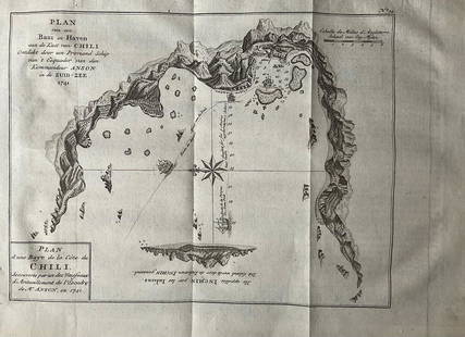
Sold2022Nautical chart of a unidentified bay in Chile. By the English pirate Anson 1749Title: Nautical chart of a unidentified bay in Chile. By the English pirate Anson 1749 Date/Period: 1749 Materials: Copper plate engraved Size: 13 1/2 x 9 3/4” Nautical chart of a unidentified BSee Sold Price
Sold2019Land Ho! Antique Narragansett Bay, RI and MA U.S. CoastDescription: Ahoy! Antique Coast Guard nautical chart of the Narragansett Bay. Numbered C. & G. S. 353; with corrections from the Coast Guard denoted in purple. Material: paper. Measurement: approximaSee Sold Price
Sold2021Oyster and Huntington Bays, NY USCGOyster and Huntington Bays, NY USCG, U.S. Coast Guard nautical chart of Oyster and Huntington Bays, S. Shore of LI Sound. Numbered C. & G. S. 224; published 1958.Approximate measurements: 36" x 41" (ISee Sold Price
Sold2021Oyster and Huntington Bays, NY USCGOyster and Huntington Bays, NY USCG, U.S. Coast Guard nautical chart of Oyster and Huntington Bays, S. Shore of LI Sound. C. & G. S. 224; published 1959. Approximate measurements: 36" x 41" (INCHES).See Sold Price
Sold2021Eight Framed New England Nautical Charts.Largest frame 49 x 36 inches. This item is not eligible for in house shipping. Buyer will be responsible for arranging pickup or delivery.See Sold Price
Sold2021Seven Old Nautical Charts.Mostly Maine, largest 44 x 36 inches. Together with a crock, repaired crack.See Sold Price
Sold2017Nautical Chart and Coastal Map of Monterey Bay, 1852Map: 1852 Nautical Chart and Coastal Map of Monterey Bay, California -- Monterey Harbor, CA from a Trigonometrical Survey Cartographer: US Coast Survey Year / Place: 1852 Map Dimensions: 13.1 x 11.7 iSee Sold Price
Sold2022Large lot of 1960s Nautical Chart Maps Martha's Vineyard, Block Island, LI Sound Cape Cod Bay & moreLarge lot of 1960s Nautical Chart Maps Martha's Vineyard, Block Island, LI Sound Cape Cod Bay & moreSee Sold Price
Sold2023NAUTICAL CHART/ INLAND WATERS SHINNECOCK BAYTO GREAT SOUTH BAYDescription: NAUTICAL CHART/ INLAND WATERS SHINNECOCK BAYTO GREAT SOUTH BAY. United states – East Cost New York South Cost of Long Island. Published at Washington D.C June 1958 (11th Edition) FSee Sold Price
Sold2023NAUTICAL CHART/ UNITED STATES EAST COST DELAWARE BAY #2Description: NAUTICAL CHART/ UNITED STATES – EAST COST – NEW JERSEY DELAWARE / DELAWARE BAY. Published at Washington D.C June 1958 (11th Edition) First Edition 1916. / US Department of CSee Sold Price
Sold2023NAUTICAL CHART/ UNITED STATES EAST COST DELAWARE BAYDescription: NAUTICAL CHART/ UNITED STATES – EAST COST – NEW JERSEY DELAWARE / DELAWARE BAY. Published at Washington D.C June 1958 (11th Edition) First Edition 1916. / US Department of CSee Sold Price
Sold2023NAUTICAL CHART/ CONNECTICUT NORTH SHORE OF LONG ISLAND SOUND NIANTIC BAY AND VICINITYDescription: : NAUTICAL CHART/ CONNECTICUT NORTH SHORE OF LONG ISLAND SOUND NIANTIC BAY AND VICINITY. Compiled and printed at Washington D.C by US Department of commerce / Luther H. Hodges, Secretary.See Sold Price
Sold2023NAUTICAL CHART EAST COAT NY/ OYSTER AND HUNTINGTON BAYS SOUTH SHORE OF LONG ISLAND SOUND. PublishedDescription: NAUTICAL CHART EAST COAT NY/ OYSTER AND HUNTINGTON BAYS SOUTH SHORE OF LONG ISLAND SOUND. Published at Washington, D.C. U.S. Department of Commerce Environmental Science Services AdministSee Sold Price
Sold2023NAUTICAL CHART EAST COAT NY/ OYSTER AND HUNTINGTON BAYS SOUTH SHORE OF LONG ISLAND SOUND. #2Description: NAUTICAL CHART EAST COAT NY/ OYSTER AND HUNTINGTON BAYS SOUTH SHORE OF LONG ISLAND SOUND. Published at Washington, D.C. U.S. Department of Commerce Environmental Science Services AdministSee Sold Price
Sold2021N. Shore of the L.I. Sound, CT USCGN. Shore of the L.I. Sound, CT USCG, Coast Guard nautical chart of the L.I. Sound CT, Niantic Bay and Vicinity. C. & G. S. 214; Approximate measurements: 30" x 33" (INCHES) Materials: PaperShipping coSee Sold Price
Sold20231914 Maritime Chart Of New York HarborUS Coast Survey Chart dated 1914. This is a nautical anchorage chart of New York Harbor, upper bay and narrows. This particular chart has areas marked where vessels were allowed to anchor in the bustlSee Sold Price
Sold2021Nautical Map / Sea Chart, #362 Block Island Sound andDescription: Nautical Map / Sea Chart, United States East Coast, New York, Long Island, Block Island Sound and Gardiner's Bay, 6th edition, Feb 10/69; Shipping: $20; different rate to California, AlasSee Sold Price
5 days LeftJasper52Antigua Falmouth English Harbour West Indies ADMIRALTY sea chart 1954 (1968) map$280
May 16Zikorn Arts & History ObjectsBosporus & Constantinople 1839 British Admiralty Nautical Chart$100
May 16Zikorn Arts & History ObjectsWest Indies, Providence, Windward, Cuba 1834 British Admiralty Map$100(1 bid)
3 days LeftHudson Valley Auctioneers LLC Beacon NYTwo nautical paintings, seascape & moored sailboats oil on canvas, seascape, small sail boat in$80(3 bids)
May 11Boston Harbor Auctions American Warship Painting of A Nautical Patrol Corvette by Worden Wood$400
15 hrs LeftThe Written Word AutographsHiroshima Mushroom Cloud Photo Signed by (5) Members of Mission$150
15 hrs LeftThe Written Word AutographsHiroshima Mushroom Cloud Photo Signed by (3) Enola Gay Crew$250
15 hrs LeftThe Written Word AutographsPhoto and Award Document for Hiroshima Mission Signed by (2) Crew$100