Sold20201940 Rock County Wisconsin Farm Plat Book w/ Maps1940 Rock County Wisconsin Farm Plat Book w/ Maps 4lbs 18 x 16 x 1/2 Shipping in continental US $25.00 If shipping is $0 then buyer arranges pick up or shipping. Please ask any questions before biddinSee Sold Price
Sold2021PLAT BOOK OF WAUKESHA COUNTY WISCONSIN 1891 ANTIQUE&PLAT BOOK OF WAUKESHA COUNTY WISCONSIN 1891 ANTIQUE& VINTAGESee Sold Price
Sold2023W. W. Kixson Kane County Illinois Plat BookDiscoloration, creasing, measures 8 1/4 X 11 inchesSee Sold Price
Sold2021Winnebago County History WI w Great ProvenanceDescribed By:Nikki CNX 1130 4276 Title:Winnebago County History WI w Prov Description:Interesting history of Winnebago county Wisconsin. This book is filled with bookmark notes from the original ownerSee Sold Price
Sold20231893 Plat Book of Henry County IllinoisPublisher - Geo. A. Ogle and Co, Chicago Illinois, With all pages and maps, Most pages loose from binding, Binding not intact, Book measures 18 x 16 x 1 inches.See Sold Price
Sold2016USGS MAPS OF SUSSEX COUNTYBOOK OF MAPS CONTAINING 21 MAPS FROM THE 1940-1950'S 22"X27"See Sold Price
Sold2023"Counties of England" Book, Circa 1834"Atlas of the Counties of England" by C&J Greenwood, 1834, comprising partially colored surveys and maps, with folio binding. Provenance: Phyllis Lucas Gallery, NYC. [25 3/4" H x 17 1/4" W]. Cover disSee Sold Price
Sold2022Natural Advanced GeographyNatural Advanced Geography Color Maps Author: jacques W. Redway Illustrations Color Maps Dated: 1898 Publisher: American Book Co.See Sold Price
Sold2019Samuel Augustus Mitchell (1790-1868), "County Map ofSamuel Augustus Mitchell (1790-1868), "County Map of Michigan and Wisconsin," 1866, H. - 12 3/8 in., W. - 15 1/4 in.See Sold Price
Sold2020MAPS, 1867, MI & WI, VIRGINIA & WEST VIRGINIAMAPS, 1867, 2, MICHIGAN & WISCONSIN, VIRGINIA & WEST VIRGINIA County maps of Virginia and West Virginia, as well as Michigan and Wisconsin. Both circa 1867. Paper size H 12 1/2'', W 15 1/2''. UnframedSee Sold Price
Sold2022Vintage Maps of Texas CountiesBound vintage book containing maps of Texas counties, featuring maps based off early twentieth century cartography 1.5"h x 17"w x 14"d We happily provide seamless shipping services on everything weSee Sold Price
Sold2018MAP OF NEW JERSEY COUNTIESOf Hamilton Farm, Hunterton, Morris, and Somerset Counties. Frame size: 27"h x 22 1/2"wSee Sold Price
Sold2018Automobile Road Map of WisconsinTitle: Automobile Road Map of Wisconsin Publication Date: 1937 Cartographer: W.W. HIXSON & CO. Publisher: W.W. HIXSON & CO. Size: 25.5X20.8 Map showing counties, towns, rivers & creeks and shows all hSee Sold Price
Sold2023Yourself & Your House WonderfulYourself and Your House Wonderful With Willy Pogany Frontis Illustration. Author: H. A. Guerber Illustrations Color B/W Illustrations Dated: <See Sold Price
Sold20231875 Illustrated Atlas Plat Map of St. Charles Co. Missouri Book1875, Publisher - W.R. Brink and Co., Several tears in pages and along front cover, Some staining, Measures 17 3/4 x 14in.See Sold Price
Sold2022Murals In The Rhinebeck Post Office New YorkMurals In The Rhinebeck Post Office (New York) with Maps, a Description of the Murals and Notes on the Town. Rare Author: Olin Dows et al. Illustrations B/WSee Sold Price
Sold2021Lot of Korean War BooksLot of Korean War Books [2] IncludesTruce Tent and Fighting Front by Hermes [with all maps in back pocket presentandThe Medic's War by Cowdrey Illustrations B/W PhSee Sold Price
Sold2023Printing InksPrinting Inks Their Chemistry and Technology Author: Carleton Ellis Illustrations B/W Photos Dated: 1940 Publisher: Reinhold Edition:See Sold Price
Sold2022RAF Bomber Command Losses vol 7 Operational Training Units 1940 1947 by W R Chorley 2002 FirstRAF Bomber Command Losses vol 7 Operational Training Units 1940 1947 by W R Chorley 2002 First Edition Softback Book with 373 pages published by Midland Counties Publications Spine in Good condition.See Sold Price
Sold2023USC&GS Map, Fowey Rocks to American Shoal, Florida KeysA color map showing the land and sea area of Fowey Rocks to American Shoal. Publishing stamp by "The U.S Coast and Geodetic Survey" located on bottom. Issued: 1940 Dimensions: 38.5"L x 34"W MaSee Sold Price
Sold2023USC&GS Map, Fowey Rocks to American Shoal, Florida KeysA color map showing the land and sea area of Fowey Rocks to American Shoal. Publishing stamp by "The U.S Coast and Geodetic Survey" located on bottom. Issued: 1940 Dimensions: 38.5"L x 34"W MaSee Sold Price
Sold2016[James Wilson]. Manuscript Plat Map of Luzerne C[James Wilson]. Manuscript Plat Map of Luzerne County, Pennsylvania with Autograph Endorsement SignedSee Sold Price
Sold2022Pamphlet on Cal. oil fields w/ color map 1865Heading: Author: Silliman, Benjamin Title: Professor Silliman's Report Upon The Oil Property Of The Pacific Coast Petroleum Company, Of New -York, Situated In San Luis Obispo County, California. To wSee Sold Price
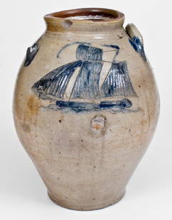
Sold2018Stoneware Jar w/ Exceptional Incised Ship, probablyOutstanding Three-Gallon Stoneware Jar with Large Incised Sailing Ship Decoration, probably Middlesex County, NJ origin, circa 1820's, highly-ovoid jar with tooled shoulder, an applied lug handle, andSee Sold Price
May 12Schilb Antiquarian Rare Books1881 Westchester County New York Yonkers Illustrated MAPS 2v SET Bolton History$26(3 bids)
Jun 05TimeLine Auctions Ltd.Archaeological Books - Ancient Egyptian Research Discoveries - Various Titles£5
5 days LeftRail & Road AuctionsEleven Port Series Books with Fold Out Maps - No. 9 Through No. 23 - Army Corps of Engineers$20(1 bid)
9 hrs LeftKellie's Estate SalesRex, Ratt, & Rock Power Vinyl 45 & 33 1/3 Singles Rock Power Magazine Presents, Love/ Hate with$5(1 bid)
May 15University Archives12 Enslaved African Americans Divided Amongst Daughters, Important Document$200


!["Counties of England" Book, Circa 1834: "Atlas of the Counties of England" by C&J Greenwood, 1834, comprising partially colored surveys and maps, with folio binding. Provenance: Phyllis Lucas Gallery, NYC. [25 3/4" H x 17 1/4" W]. Cover dis](https://p1.liveauctioneers.com/1221/310017/167287172_1_x.jpg?height=310&quality=70&version=1702345351)


![Lot of Korean War Books: Lot of Korean War Books [2] IncludesTruce Tent and Fighting Front by Hermes [with all maps in back pocket presentandThe Medic's War by Cowdrey Illustrations B/W Ph](https://p1.liveauctioneers.com/5614/198722/100433629_1_x.jpg?height=310&quality=70&version=1616769292)


![[James Wilson]. Manuscript Plat Map of Luzerne C: [James Wilson]. Manuscript Plat Map of Luzerne County, Pennsylvania with Autograph Endorsement Signed](https://p1.liveauctioneers.com/906/86611/44529635_1_x.jpg?height=310&quality=70&version=1458833472)