Sold20181982 Horsey Pictorial Map of the World According toTitle/Content of Map: 1982 Horsey Pictorial Map of the World According to Ronald Reagan -- The World According to Ronald Reagan Date Printed: 1982 Cartographer: D Horsey / Seattle Post-Intelligencer SSee Sold Price
Sold20231939 Chase World Pictorial Map - World Wonders A Pictorial Map Designed and drawn by Ernest DudleyTitle: 1939 Chase World Pictorial Map - World Wonders A Pictorial Map Designed and drawn by Ernest Dudley Chase Cartographer: E D Chase Year / Place: 1939 Map Dimension (in.): 27.5 X 17.5 in. This supSee Sold Price
Sold2023Dufour, F. 1879 Map. World according to Sebastien Cabot"Le Monde d'apres les idees de Sebastien Cabot en 1544" Lithograph Map Published 1879, Paris for "Les Marins du XVe et du XVIe siecle" by Vice-Admiral Edmond Jurien de La Graviere. Folds as issued. PaSee Sold Price
Sold20211939 Chase Pictorial Map of World's Wonders -- WorldTitle: 1939 Chase Pictorial Map of World's Wonders -- World Wonders A Pictorial Map Designed and Drawn by Ernest Dudley Chase of Winchester, Massachusetts Cartographer: E D Chase Year / Place: 1939 c.See Sold Price
Sold2023Calmet, Augustin 1732 Large Map. Old World according to Noah's Sons"A Geographical Map of the Old World according to the division of it among Noah's Sons" Folio Copper Plate Published 1732, London for "An Historical, Critical, Geographical, Chronological and EtymologSee Sold Price
Sold2022Marvelous pictorial map of the WorldHeading: (Maps) Author: Ensign & Thayer Title: World at One View Place Published: New York Publisher: Date Published: 1847 Description: Lithographed double-hemisphere map of theSee Sold Price
Sold2018Vintage Polar Projection of WWII World Pictorial MapTitle/Content of Map: 1943 Alcoa Aluminum Polar Projection of World at World Pictorial Map -- Global Map for Global War and Global Peace Date Printed: 1943 Cartographer: Alcoa Aluminum Co. Size: 24.4See Sold Price
Sold2018PanAM: Vintage Pictorial World Map, 1957Title/Content of Map: 1957 PanAM Pictorial World Map -- Your Clipper Cargo Market Area Date Printed: 1957 c. Cartographer: PanAm Size: 22 x 34 in. A very interesting world map showing PanAm cargo routSee Sold Price
Sold20181967 PanAm Pictorial Map of the World -- [World]Title/Content of Map: 1967 PanAm Pictorial Map of the World -- [World] Date: 1967 Cartographer: J Liozu / PanAm Size: 5.6 x 8.1 in. Very attractive pictorial map of the World, that is the cover of theSee Sold Price
Sold2023Cartography14. Cartography.A New and Correct Map of the World According to the Latest Discoveries. Double-page engraved map. 17 x 26-1/2 inches, outlined in color; a few stains, hole at upper right corner, generSee Sold Price
Sold2022Herman Moll's New Map of the World - California as an Island!, Ca. 1725Herman Moll's New Map of the World - California as an Island!, Ca. 1725 1p, measuring 13.625" x 8.5", n.p., ca. 1725. A hand-colored map entitled "A New Map of the World according to the New ObservatiSee Sold Price
Sold2020Illustrated Van Loon Hand-Colored World Map, 1932Hendrik Willem Van Loon (Dutch-American, 1882-1944). Illustrated World Map, 1932. A hand colored outlined pictorial map of the world on Mercator projections with topographical relief shown pictoriallySee Sold Price
Sold2022MAP, World, JannotWorld. J.B. Jannot, Le Tour du Monde en 120 Images Grand Concours du Chocolat Menier, 1956 (circa). Printed Color. This attractive and novel pictorial map of the world was created by J.B. Jannot and pSee Sold Price
Sold20181943 Alcoa Aluminum Polar Projection of World at WorldTitle/Content of Map: 1943 Alcoa Aluminum Polar Projection of World at World Pictorial Map -- Global Map for Global War and Global Peace Date Printed: 1943 Cartographer: Alcoa Aluminum Co. Size: 24.4See Sold Price
Sold2018HERMANN MOLL (BRITISH, 1654-1732) MAP OF THE WORLDHERMANN MOLL (BRITISH, 1654-1732) MAP OF THE WORLD, engraving on laid paper, double hemispheric form with North Pole inset, showing California as an island, titled "A NEW MAP OF THE WORLD according toSee Sold Price
Sold20191943 Alcoa Aluminum Polar Projection of World at WorldTitle/Content of Map: 1943 Alcoa Aluminum Polar Projection of World at World Pictorial Map -- Global Map for Global War and Global Peace Date: 1943 Cartographer: Alcoa Aluminum Co. Size: 24.4 x 33 in.See Sold Price
Sold2022Pictorial Map Vintage GameThe Wide World by Henrik van Loon. Pictorial world map board game. Ship, plane game pieces, cards, instructions, in bpx. Parker Brothers. Cartography collectible.14" x 20" x 2". Box as found.See Sold Price
Sold2022World.- Speed (John) A New and Accurat Map of the World Drawne according to ye truest DescriptionsWorld.- Speed (John) A New and Accurat Map of the World Drawne according to ye truest Descriptions latest Discoveries & best observations yt have beene made by English or Strangers, double-hemisphereSee Sold Price
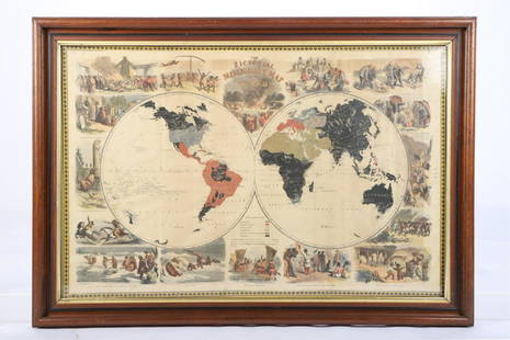
Sold2021PICTORIAL MISSIONARY MAP OF THE WORLDHand colored lithograph featuring map of the globe with vignettes of the introduction of Christianity in various cultures of the world, published in 1861, sight size 18 3/4 x 28 3/4 inches, set in oriSee Sold Price
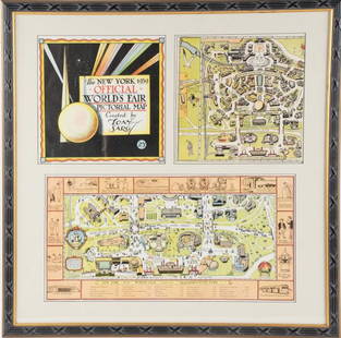
Sold2022Framed Tony Sarg 1939 World's Fair Pictorial MapTony Sarg (American, 1880-1942), "The New York 1939 Official World's Fair Pictorial Map Created by Tony Sarg 25¢" cover and Transportation Zone maps, three pieces matted and under glass in paintedSee Sold Price
Sold2023Calmet, Augustin 1732 Large Map. Creation of the World according to MosesFolio Copper Plate Published 1732, London for "An Historical, Critical, Geographical, Chronological and Etymological Dictionary of the Holy Bible" First English Edition by Augustin Calmet. Paper Size:See Sold Price
Sold1939 New York World's Fair Official World's Fair Pictorial Map1939 New York Worlds Fair Official Worlds Fair Pictorial Map by Tony Sarg in very good to excellent condition as seen in the photos.See Sold Price
Sold2016JOHN SPEED (BRITISH, 1552-1629) MAP OF THE WORLDJOHN SPEED (BRITISH, 1552-1629) MAP OF THE WORLD, (UPDATED 6/14/16) hand-colored engraving on laid paper, titled "A New and Accurat Map of the World Drawne according to ye truest Descriptions latest DSee Sold Price
Sold2022(2) LUCIEN BOUCHER , ORIGINAL PICTORIAL MAPLUCIEN BOUCHER (1889-1971) (2) ORIGINAL AIR FRANCE COLOR LITHOGRAPH PLANISPHERE PICTORIAL TRAVEL MAPS OF THE WORLD FOR AIRLINE DESTINATIONS OF AIR FRANCE , TITLED "NOVA ET VETERA" , Sur La Vieille TerSee Sold Price
May 16Potter & Potter Auctions[NEW YORK CITY – PICTORIAL MAPS]. Group of 3 pictorial maps...$200(1 bid)
May 16Potter & Potter AuctionsLANGENECKERT. It’s A Dog’s World. 1968. St. Louis: Ralston ...$100
May 16Potter & Potter AuctionsPictorial Map of Hollywood and Vicinity / Hollywood Film Ca...$125(1 bid)
May 16Potter & Potter AuctionsTUNIS, Edward (1897 – 1973). From Chesapeake Bay / Land of ...$250
5 days LeftHunt and Peck Estate Services, Inc.Chart Of The World According To Mercators Projection Showing Tracks & Discoveries Of Capt. Cook$140
May 16Potter & Potter AuctionsHANDY, R.D. (1879 – 1959). Paul Bunyan’s Pictorial Map of t...$200
3 days LeftJasper521960 Alaska Cruise Lines Pictorial Map of Alaska -- State of Alaska Visitor's Map$30
May 16Potter & Potter AuctionsSTORM, Mark. Official Texas Brags Map of North America. 194...$200(1 bid)
May 16Potter & Potter AuctionsLINDGREN, Jolly (1895-1952). A Hysterical Map of Yellowstone Park and the Jackson Hole Country$125


![1967 PanAm Pictorial Map of the World -- [World]: Title/Content of Map: 1967 PanAm Pictorial Map of the World -- [World] Date: 1967 Cartographer: J Liozu / PanAm Size: 5.6 x 8.1 in. Very attractive pictorial map of the World, that is the cover of the](https://p1.liveauctioneers.com/5584/125363/63781364_1_x.jpg?height=310&quality=70&version=1533078308)


![[NEW YORK CITY – PICTORIAL MAPS]. Group of 3 pictorial maps... (1 of 3)](https://p1.liveauctioneers.com/928/325952/175495562_1_x.jpg?height=282&quality=70&version=1712935174)


