Sold2023Ohio Agricultural Map 1872Framed map showing crops and livestock regions. Frame is 12 1/2'' x 16''. Frame has some condition issues.See Sold Price
Sold20232 Framed Maps of Canada & U.S.Group of two framed maps depicting Canada and the United States. One map depicting the East Coast of the United States as well as southeastern Canada. One map depicting Lake Superior and south-centralSee Sold Price
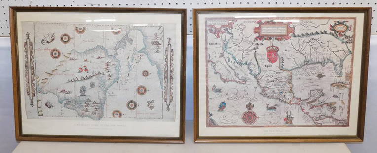
Sold2015Lot of 2 framed mapsNovi Begii map of New England & Map of the Worls by Nicholas Visscher. 24"h x 27"w framed.See Sold Price
Sold20232 FRAMED MAPS, 1723 SO. AMERICA & THE ROMAN ROADS OF BRITIAN (24 1/2" X 20")2 FRAMED MAPS, 1723 SO. AMERICA & THE ROMAN ROADS OF BRITIAN (24 1/2" X 20")See Sold Price
Sold2024(2) FRAMED MAPS OF MARYLAND, CIRCA 1900Including: St. Michaels of Talbot Co., in black and gold stick frame, matted and glazed, OS: 16 1/2" x 13", SS: 13" x 10"; PLUS Trappe, Oxford & Bay Hundred, also Talbot Co. Similar frame, OS: 23 1/2"See Sold Price
Sold20232 Framed Maps2 Framed Maps . 25" X 19 3/4" ALL DESCRIPTIONS AND ANY CONDITION STATEMENT GIVEN BY LANGSTON AUCTION GALLERY ARE STRICTLY OPINIONS AND LANGSTON'S SHALL HAVE NO RESPONSIBILITY FOR ERRORS OR OMISSIONS.See Sold Price
Sold20212 FRAMED MAPSTWO FRAMED MAPS INCLUDING EASTON PA, PHILLIPSBURG. LARGEST MAP HAS DAMAGE TO UPPER LEFT & NO GLASS BY SW ROCKWELL. 36 3/4 IN X 37 1/2 IN INCLUDING FRAMESee Sold Price
Sold20212) STIELER & MITCHELL MAPS EUROPE, TURKEY & GREECE(lot of 2) Framed maps, including: (1) engraving with hand coloring on paper, German map of Europe, Turkey, Greece, and the Ionian Islands, from "Stielers Schul-Atlas," published by Justus Perthes, GoSee Sold Price
2019Framed MapsLot (2) framed maps. Includes Map Of New York Arsenal, N.Y. (sight 11" x 7"), and New-York (sight 9" x 10").See Sold Price
Sold2017LOT OF (2) FRAMED COLORED MAPS, 19TH CENTURYOne is Mexico Overall framed- 21" x 26", 22 3/4" x 27"See Sold Price
Sold20182 Framed antique maps2 Framed antique maps, probably from an old atlas, British America & The United States, map drawn & engraved by J. Rapkin, illustrations by H. Warren & illustrations by R. Wallis, Maps are 10" x 13",See Sold Price
Sold20232 Framed Historical Maps, North America & Kentucky, Carey & Lea1st item: Geographical, Statistical & Historical map of North America, 1823, published by Henry Charles Carey (1793-1879) and Isaac Lea (1792-1886) Philadelphia, illustrated by J. Yeager. From A ComplSee Sold Price
Sold2021(2) ANTIQUE FRAMED MAPSAntique world map approximately 16" x 9.75" w/ frame and Asia minor 11.75" x 9.25" w/ frame.See Sold Price
Sold20242 ANTIQUE FRAMED MAPSMAP OF FRANCE, DATED 1850, BY THOMAS COWPERTHWAIT AND ONE OF ENGLAND. FRAMED 21"X 24"See Sold Price
Sold20172 Framed World Maps including Blaeu Wall Map2 Framed World Maps including Blaeu Wall Map. Largest measures 22 x 26 inches.See Sold Price
Sold2023Framed Antique Agricultural Map Of NY State, 1843Marked on lower left corner reads Agricultural map of the state of New York. Lith of G & W endicott New York, Map is colored in correspondence with the color of agriculture throughout the state. FrameSee Sold Price
Sold20202 antique framed Southern maps2 antique framed maps: Map of South Carolina in German dated 1845. Map of Savannah and Charleston published by G.W and C.B Colton & Co and dated 1855. Overall size measures 25 1/2"h x 28"w and the papSee Sold Price
Sold2018Set of 2 Framed Prints of Antique MapsSet of 2 Framed Antique Maps - Small map of England and Scotland. Large Map of the Mediterranean with ships. Measures approx. Large map 28" tall x 31" w x 1" deep. Small map 12" tall x 15" w x 3/4" deSee Sold Price
Sold2022LOT 2 FRAMED ITEMS-MAP OF CAPECOD 23 1/2"H X 26 1/2"W & 17 1/2" X 23 3/4"LOT 2 FRAMED ITEMS-MAP OF CAPECOD 23 1/2"H X 26 1/2"W & 17 1/2" X 23 3/4"See Sold Price
Sold2023[ANTIQUE MAP] ANTIQUE MAP OF SOUTHERN SCOTLAND. c. 1650s[ANTIQUE MAP] CARTE L'ECOSSE SUIVANT LES DERNIERES RELATIONS par N...Sanson, Circa 1650s Framed size (approx): 8.1/4"x10.1/4" Image size: (approx):6.3/4"x7.1/2" Framed. This map hasn't been examined uSee Sold Price
Sold20222 PC. FRAMED ANTIQUE MAPS OF ISRAEL2 PC. FRAMED ANTIQUE MAPS OF ISRAEL: Comprising; 1- Detailed Ortelius Map of the Holy Land, Based on Tilemann Stella's Extremely Rare Holy Land Maps. 1- Homann based this map of the Holy Land on the cSee Sold Price
Jun 29George Cole AuctionsLot 2 Framed Hand Colored Engr 18th C Map Of India + Environs 6" X 8 1/4" + Poughkeepsie 3 3/4" X 7$30
3 days LeftRapid Estate Liquidators and Auction GalleryFramed Vintage Map Of Le Port Au Prince In The Island Of Santo Domingo$90
4 days LeftDOYLE Auctioneers & AppraisersAn attractive eighteenth-century Dutch map of the Americas$150
4 days LeftDOYLE Auctioneers & AppraisersOrtelius' historical map of antique "Magna Graecia," present-day Southern Italy$150
5 days LeftRail & Road AuctionsSix Union Pacific Railroad Items - Wall Lamp, China Plates, Travel Guide, Menu, and Framed$30


![[ANTIQUE MAP] ANTIQUE MAP OF SOUTHERN SCOTLAND. c. 1650s: [ANTIQUE MAP] CARTE L'ECOSSE SUIVANT LES DERNIERES RELATIONS par N...Sanson, Circa 1650s Framed size (approx): 8.1/4"x10.1/4" Image size: (approx):6.3/4"x7.1/2" Framed. This map hasn't been examined u](https://p1.liveauctioneers.com/8321/286473/155324781_10_x.jpg?height=310&quality=70&version=1687035305)


