Sold2023A Description Of The Land Of Gosen Framed MapHand colored paper map reading A Description of the land of Gosen, and Mosses passage through the desserts. Framed in gold metal leafed wooden frame with lined inner edge and gold leafed inner fillet.See Sold Price
Sold2024William Hole "A Description of the land of Gosen, and Moses passage though the Deserts"Map from Raleigh's History of the world 1652. This map charts the legendary journey of Moses, leading the Israelites out of Egyptian captivity. It depicts their escape route, including the dramatic paSee Sold Price
Sold2022Framed Nicolas de Fer Four Grand Monarchies PrintDESCRIPTION: Framed color print of a map entitled "The Four Great Monarchies of the Assyrians, the Persians, the Greeks, and the Romans" by Nicolas de Fer depicting the lands around the MediterraneanSee Sold Price
Sold2023Antique Framed Land Map Constable Burton YorkshireAntique Framed Land Map of Constable Burton North RIding of Yorkshire. Framed measures 20 inches x 25 inches.See Sold Price
Sold2023FRAMED ANTIQUE WORLD MAP BY PETER APIAN - 1520Description: FRAMED ANTIQUE WORLD MAP BY PETER APIAN - 1520Measurement approximate:Material: PaperSee Sold Price
Sold202219th C Kittanning, Pennsylvania MapItem/Description: Framed antique wall map features nine building insets including the old courthouse, churches and residences. "Map of Kittanning Armstrong Co. Penna. Surveyed, drawn & published by ThSee Sold Price
Sold20151838 Drawing by John Paul of Monroe Garden PADESCRIPTION: 1838 framed land drawing on paper with accompanying text by John Paul of the Monroe Garden of Mifflin Township, Dauphin County, Pennsylvania. MEASUREMENTS: Taken to frame 19" x 15-3/4". CSee Sold Price
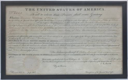
Sold2023Signed By US President John Quincy Adams 1825 American Land Grant Delaware County OHTitle:1825 American Land Grant Signed By US President John Quincy Adams Description: Framed 1825 Land Grant signed by then-President John Quincy Adams to a one Hiram Holmes of Delaware County, OH forSee Sold Price
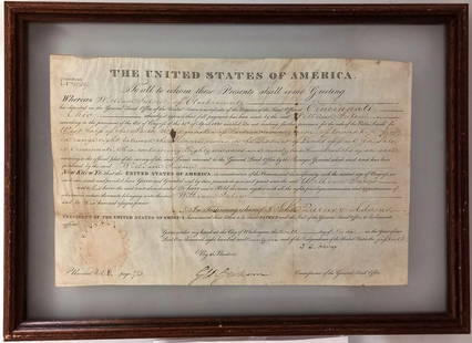
Sold2023Signed By US President John Quincy Adams 1826 American Land Grant Clark County OHTitle:1826 American Land Grant Signed By US President John Quincy Adams Clark County OH Description: Framed 1826 Land Grant signed by then-President John Quincy Adams. We believe the grant is issued tSee Sold Price
Sold2017Vintage Framed Map of Paris TapestryItem: Description: Vintage framed French Gobly tapestry Map of Paris. It is signed “Goblys” and Measures 21" x 21". Please note that this lot has a confidential reserve. When you leave a bid in adSee Sold Price
Sold2018Scotland Pictorial Map - The British & Holiday Asso.Description: Antique framed original Scotland pictorial map by the permission of the British & Holiday Association.Measurement approximate: 32 H x 20 W. Material: All Pure Linen Fabric. Shipping cost:See Sold Price
Sold20211906 Area Comparison MapAuthor: Cram Title: 1906 Area Comparison Map Medium: Ink on Paper Dimensions: 15"X11" Description: Map of land comparison between US and European powers dated 1906. Printed and published by George CraSee Sold Price
Sold2021Decorative Framed Double Hemisphere MapDESCRIPTION: A decorative framed double hemisphere map with figural and gilt details throughout. Mounted in a gilt accented wood frame. Marked: "The Bombay Company" at reverse. CIRCA: 20th Cent. ORIGISee Sold Price
Sold20231979 Town of Woodbury, Conn Framed MapDescription: This lot includes a framed map of Woodbury Conn from there American Bi-Centennial in 1979. Original map was done by L. Fagan in 1853. Condition: Minor expected surface wear associated witSee Sold Price
Sold2023Framed Map of Spanish & Mexican Land Grants for King RanchFramed and glazed colored map depicting the coastal area between the Rio Grande and The Nueces, showing early Spanish and Mexican land grants for King Ranch as of 1852 We happily provide seamless shiSee Sold Price
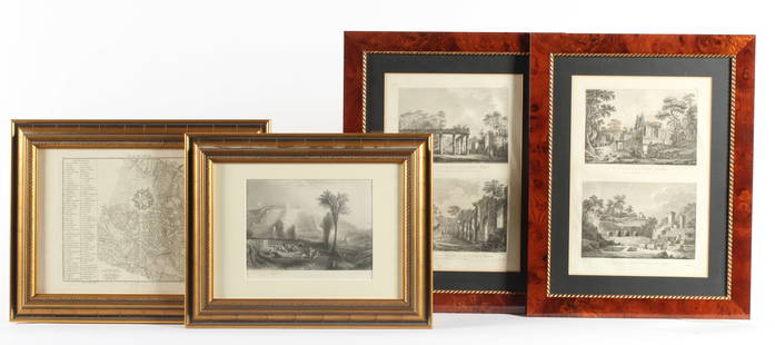
Sold2023Four Antique European EngravingsDescription: Each professionally framed, to include a 1796 map of Milan by J. J. De La Lande, a 19th century steel engraving after J.M.W. Turner of Ehrenbreitstein, and two plates depicting scenes ofSee Sold Price
Sold2023MAP: ANTIQUE 1737 JOHANN BAPTIST .B HOMANN- AFRICA SECUNDUM LEGITIMASDescription: Framed Antique 1737 - J.B HOMANN- AFRICA SECUNDUM LEGITIMAS. Johann Baptist Homann (20 March 1664 -1 July 1724) was a German geographer and cartographer, who also made maps of the AmericaSee Sold Price
Sold2022Framed Map of the Territory of UtahMap of the Territory of Utah, Department of the Interior General Land Office, 1866, engraving on wove paper with colored highlights, sight 26 x 18-1/2 in.; wood frame, 24-1/2 x 27-3/8 in. Provenance:See Sold Price
Sold2020Antique Johnson and Ward "Holy Land" MapDESCRIPTION: map of the Holy Land, based upon the 12 tribes and contemporary (to mid-19th Century) borders. Insets of view of Damascus and town plan of Jerusalem. Shows towns, roads, rivers, lakes, moSee Sold Price
Sold2023Framed Map of Long Island by George H. Moore, The Dukes Plan 1859Framed Map of Long Island by George H. Moore, The Dukes Plan 1859. This is an excellent framed map of Long "Isleland." It is labeled, "The Dukes Plan." And it is, "A Description of the towne of MannadSee Sold Price
Sold2023MAP: BRITANIA / Eng. BY G.E. Sherman N.Y/ Philadelphia, Blanchard & LeaDescription: Framed BRITANIA / Eng. BY G.E. Sherman N.Y/ Philadelphia, Blanchard & LeaMaterial: PaperMeasurement approximate: 23 x 19 Frame/ 19 x 15 Image (Inches).See Sold Price
Sold20231871 Framed Map of St. Albans, VT1871 map and directory of Saint Albans, Vermont. Map shows roads, businesses, land ownership, natural features. Some yellowing, water damage present. Framed, 31"x37"See Sold Price
Sold20164 Anyique Framed MapsLot includes 4 gold framed antique maps, in order 1 map is marked on bottom Series M2 Hoffmann-Laroche Inc. Nutley 10, NJ and Totled at the top in the map Geographia Sacra emphasis on land continents,See Sold Price
Sold20164 Anyique Framed MapsLot includes 4 gold framed antique maps, in order 1 map is marked on bottom Series M2 Hoffmann-Laroche Inc. Nutley 10, NJ and Totled at the top in the map Geographia Sacra emphasis on land continents,See Sold Price
2 days LeftActivity AuctionsDisneyland Fantasyland's "Storybook Land" 15x26 Custom Framed Print Display with Vintage 1960s$150
2 days LeftRapid Estate Liquidators and Auction GalleryFramed Collection Engravings & A Map From The Excursions In The County Of Sussex Published In 1822$50
2 hrs LeftJasper521814 Aaron Arrowsmith map. Israelites from Egypt to Canaan through the desert of Arabia Petraea$140
6 days LeftWinter Associates Three historical engraved maps of the Caribbean, ranging from 1616-1814, each hand colored, framed$100(1 bid)
Jun 19Flanders AuctionsAn antique map of Ingelumunster and two 'Heerlijkheden van Picquenij', 18th C. (W:42 x H:33 cm)€160
1 day LeftWhite Knight Auction, IncThomas Kinkade 'Peter Pan'S Never Land' Signed & Numbered Lithograph, 2016$250
3 days LeftFreeman's | Hindman[MAP]. ORTELIUS, Abraham. Presbiteri Iohannis, sive, Abissinorum Imperii Descriptio. 1592.$200
4 days LeftTrillium Antique Prints & Rare BooksDavid Roberts - Pair of Lithographs of Views of Nubia$100


![[MAP]. ORTELIUS, Abraham. Presbiteri Iohannis, sive, Abissinorum Imperii Descriptio. 1592. (1 of 2)](https://p1.liveauctioneers.com/197/329395/177650536_1_x.jpg?height=282&quality=70&version=1715364962)


