Sold2017Coast of West Florida and Louisiana Map"Coast of West Florida and Louisiana", by Thomas Jefferys (English, 1719-1771) copperplate engraved map, with the New Orleans environs heightened with hand-colored gold, published London, 1775. MattedSee Sold Price
Sold2021Thomas Jefferys (English, 1719-1771)Thomas Jefferys (English, 1719-1771) , "The Isthmus of Panama with the Coast from Great River on the Moskito Shore to Cartagena", London, Laurie & Whittle, 1794, from West India Atlas, 19 in. x 24 1/2See Sold Price
Sold2020Thomas Jefferys Old Map of Ruatan Island HondurasThomas Jefferys (English, c. 1719-1771). Framed antique etching print of Ruatan Island, Honduras. Titled RUATAN OR RATTAN, SURVEYED BY LIEUTENANT HENRY BARNSLEY WITH IMPROVEMENTS BY THOMAS JEFFERYS. HSee Sold Price
Sold2016Thomas Jefferys (1719-1771), "Course of the RiverThomas Jefferys (1719-1771), "Course of the River Mississippi from the Balise to Fort Chartres," 20th c., after the 1775 original, presented in a silver gilt frame, H.- 48 3/8 in., W.- 21 7/8 in.See Sold Price
Sold2017Jefferys: Antique Map of Europe, 1763Map: Europe. Publication Date: 1763 ca. Authors: JEFFERYS, T. Size: Octavo – 7.10 H x 8.80 W Inches T. Jefferys, Sc. On polar projection Thomas Jefferys (1719-1771) was the Royal Cartographer tSee Sold Price
Sold2019Thomas Jefferys (1719-1771), "The East Indies withThomas Jefferys (1719-1771), "The East Indies with Roads," in two parts, 1768, hand colored, Each- H. - 21 in., W. - 55 in. (2 Pcs.)See Sold Price
Sold2019Thomas Jefferys (1719-1771), "Kingdom of Bohemia withThomas Jefferys (1719-1771), "Kingdom of Bohemia with the Dutchy of Silesia and Marquisates of Moravia and Lusatia," 1794, H. - 21 1/4 in., W. - 28 1/2 in.See Sold Price
Sold2017Important early map of St. Johns Island by T. JefferysA Map of the Island of St. John in the Gulf of St. Laurence...Thomas Jefferys (c. 1719 – 1771). Copperplate engraved map with handcolor in outline. London: Sayer & Bennett, 1775. 21 1/2 x 29 inchesSee Sold Price
Sold20231752 Map East Indies, Thomas JefferysHand-colored map published in London by cartographer and engraver Thomas Jefferys (ca. 1719-1771.) Jefferys was geographer to Frederick Prince of Wales and to King George III. Map, approx. 11" x 7". FSee Sold Price
Sold2017First state of this handsome sailing chart of The GulfA Chart of the Gulf of St. Laurence...Thomas Jefferys (c. 1719 – 1771). Copperplate engraved map. London: Sayer & Bennett, 1775. 21 1/2 x 29 inches sheet. First state of this handsome sailing chartSee Sold Price
Sold2017Jefferys' 18th Century Map of the Banks of NewfoundlandA chart of the Banks of Newfoundland... Drawn from Chabert, Cook and Flerieu...Thomas Jefferys (c. 1719 – 1771). Copperplate engraved map handcolored in outline. London: Sayer & Bennett, March, 1775See Sold Price
Sold20201752 Map East Indies, Thomas JefferysHand-colored map published in London by cartographer and engraver Thomas Jefferys (ca. 1719-1771.) Jefferys was geographer to Frederick Prince of Wales and to King George III. Map, approx. 11" x 7". FSee Sold Price
Sold2024Thomas Jefferys - Map of Hungary with Turky in Europe [shows Cyprus]Hand-coloured decorative map of Hungary, Greece, Turkey, Cyprus, and the Gulf of Venice, showing provinces, towns, islands, rivers, etc. Thomas Jefferys (ca. 1719-1771) was a prolific map publisher, eSee Sold Price
Sold2023Jefferys, Authentic Plan of the River St. Laurence - First StateJEFFERYS, Thomas (c. 1719 - 1771). An Authentic Plan of the River St. Laurence from Silleru to the Fall of Montmorenci with the operations of the Siege of Quebec... Engraved map with original hand colSee Sold Price
Sold2018THOMAS JEFFERYS (ENGLISH, C. 1710 TO 1771) MAP OFTHOMAS JEFFERYS (ENGLISH, C. 1710 TO 1771) MAP OF HONDURAS, hand-colored, on laid paper, lettered to upper margin "The BAY of HONDURAS. By Tho.s Jefferys Geographer to His Majesty", and to lower margiSee Sold Price
Sold2019Virgin Islands Carribbean Sea ChartThe Virgin Islands from English and Danish Surveys by Thomas Jefferys. English map. Sight 18 1/2" x 24 1/2".See Sold Price
Sold2021Thomas Kitchin Map of "South America"Thomas Kitchin (English, 1718-1784). "South America with its Several Divisions". A hand colored and engraved map with vertical central fold. 18" x 22" (sight), 26" x 29" (framed).See Sold Price
Sold2018The Virgin Islands from English and Danish Surveys byThe Virgin Islands from English and Danish Surveys by Thomas Jefferys Geographer to the King, sight size: 18 1/2" x 24" Provenance: Estate of Peggy & David Rockefeller having stamp/label.See Sold Price
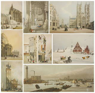
Sold20208 Thomas Shotter Boys lithographsThomas Shotter Boys (English 1803-1874)- ''Belfry, Ghent''; ''The South Porch of Chartres Cathedral''; ''Hotel de la Tremouille, Rue Des Bourbonnes''; ''Saint Chapelle''; ''By Loke, Ghent''; ''WestminSee Sold Price
Sold2024Historical Fashion Costume Antique Print LotLot of various 18th century engravings English and European aristocrats in traditional dress or costume. Thomas Jefferys, London: 1772. Includes peoples of England, Spain and Italy. 10 3/4" x 7 12".See Sold Price
Sold2022Native American Indian Costume Prints (10)Set of 10 engravings North and South America indigenous people in native dress or costume. Thomas Jefferys, London: 1772. Includes Mohawk, Virginia, Patagonian, historical events, etc. 10 1/2" x 8".See Sold Price
Sold2023Antique English Silver TeapotAntique English silver teapot with elaborate spout with acorn finial cover and wood handle; engraved on the side and bottom, "London, Thomas Woodhouse, 1771". (24 ozt. inclusive). [10" H x 8 1/2" W xSee Sold Price
Sold2016Canada.- Jefferys (Thomas) - An Authentic Plan of thewith the Operations of the Siege of Quebec , with inset map showing part of the Upper River of St. Laurence, and an inset View of the Action gained by the English Sep. 13th 1759, engraved map, 340 x 5See Sold Price
Sold20171771 New Geographical Grammar Thomas Salmon Atlas1771 New Geographical Grammar Thomas Salmon 24 Atlas MAPS Europe France Scotland Thomas Salmon was a famous English historian, known for his books on geography, English history, and travel. His most fSee Sold Price
2 days LeftJeffrey S. Evans & AssociatesFREE-BLOWN THOMAS CAINS CHAIN-DECORATED QUART DECANTER$120(3 bids)
Jul 06Case Antiques, Inc. Auctions & AppraisalsThomas Lewis Family Letter Archive; Boston, Massachusetts$200
Jun 25Freeman's | Hindman[Fishing] [Gosden, Thomas] Bowlker, Richard: The Art of Angling...$250(1 bid)
Jun 25Freeman's | Hindman[Fishing] [Bewick, Thomas, and Thomas Gosden, et al.] Group of 18 Angling-Themed Book-Plates$150
7 days LeftCurated Gallery AuctionsThomas Creswick (1811 - 1869) Antique English 19th Century Landscape Framed Original Oil Painting$10
Jul 06Case Antiques, Inc. Auctions & Appraisals4 pcs. Aesthetic Movement Sterling Cream/Sugar Set plus Small Oval Dish$200
3 days LeftSwann Auction GalleriesJOHN THOMAS YOUNG GILROY (1898-1985) "The Animal Party" and "The Boxing Brunch."$600
7 days LeftCurated Gallery AuctionsAntique English Signed Luminous Landscape Framed Thomas Williams Original Oil Painting$10
3 days LeftJeffrey S. Evans & AssociatesTHOMAS HARRISON, DANVILLE, KENTUCKY RETAILED, D. EDMONDS, ENGLISH GEORGIAN BRASS PAIR CASED KEY-WIND$400
Jun 30South Jersey Auction by Babington Auction IncMid C. oil on board in vintage frame, Margaret Thomas$25(1 bid)
Jul 07A-1 Auction18th Century Large Portrait In the Style of Thomas Gainsborough 1727-1788$850(6 bids)


![Thomas Jefferys - Map of Hungary with Turky in Europe [shows Cyprus]: Hand-coloured decorative map of Hungary, Greece, Turkey, Cyprus, and the Gulf of Venice, showing provinces, towns, islands, rivers, etc. Thomas Jefferys (ca. 1719-1771) was a prolific map publisher, e](https://p1.liveauctioneers.com/8353/325198/175261422_1_x.jpg?height=310&quality=70&version=1712598926)


![[Fishing] [Gosden, Thomas] Bowlker, Richard: The Art of Angling... (1 of 3)](https://p1.liveauctioneers.com/65/332523/179335078_1_x.jpg?height=282&quality=70&version=1717622830)
![[Fishing] [Bewick, Thomas, and Thomas Gosden, et al.] Group of 18 Angling-Themed Book-Plates (1 of 1)](https://p1.liveauctioneers.com/65/332523/179335068_1_x.jpg?height=282&quality=70&version=1717622830)


