Sold2018Air India "Routes of My Jet Carpet" Route Map Circa 196Air India "Routes of My Jet Carpet" Route Map Circa 1964. 16 3/4" x 39"See Sold Price
Sold20181961 Panagra / PanAm Pictorial Map of South AmericanTitle/Content of Map: 1961 Panagra / PanAm Pictorial Map of South American Air Routes -- The Only Jet Service 'Round South America Date: 1961 Cartographer: PanAm Size: 10.5 x 8 in. A nice air Route MaSee Sold Price
Sold2020Air France. Flying Holidays this Year! Circa 1935.Air France. Flying Holidays this Year! Circa 1935. Offset lithograph travel poster with the airline’s route map printed within the outline of a propeller plane, covering major cities of Europe aSee Sold Price
Sold2018Pan American Jet Clipper Route Maps 1964Pan American jet clipper route maps, dated 8/64.See Sold Price
Sold20181947 World Route Map of US Flag Airlines --Title/Content of Map: 1947 World Route Map of US Flag Airlines -- International Air Routes of U.S. Flag Carriers as of April, 1947 Date: 1947 Cartographer: Anonymous Size: 10.9 x 21 in. This fascinatiSee Sold Price
Sold20201930 Japanese Mainichi Newspaper World Air RouteTitle: 1930 Japanese Mainichi Newspaper World Air Route Pictorial Map -- Conquer Sky Sugoroku [World Air Route Map] Cartographer: Mainichi Newspaper Year / Place: 1930, Osaka Map Dimension (in.): 26.8See Sold Price
Sold2018Avianca Air Routes Map Luxury Flights on Lockheed SuperAvianca Air Routes Map Luxury Flights on Lockheed Super Constellation 1957See Sold Price
Sold2018KAC Kuwait Airways Route Map Circa 1975KAC Kuwait Airways route map, circa 1975. 35"x17"See Sold Price
Sold2018North Atlantic Airlines Route Map Information Booklet CNorth Atlantic Airlines Route Map Information Booklet Circa 1950sSee Sold Price
Sold2016Lucien Boucher Air France World Map of Air Routes,Lucien Boucher Air France World Map of Air Routes, original poster printed by Perceval c.1939 - 63 x 99 cmSee Sold Price
Sold2016Lucien Boucher Air France World Map of Air Routes,Lucien Boucher Air France World Map of Air Routes, original poster printed by Perceval c.1939 - 64 x 101 cm Crinkled paperSee Sold Price
Sold2017Bartholomew: Map of Routes to India, 1912Title/Content of Map: 'Routes to India; Inset maps of Gibraltar; Maltese Islands; Suez Canal' This map is folding hence the centrefold line may show on the image below Date Printed: 1912 Image Size: ASee Sold Price
Sold20221945 TWA Route Map -- TWA Air AtlasTitle: 1945 TWA Route Map -- TWA Air Atlas Cartographer: TWA Year / Place: 1945 Map Dimension (in.): 9.1 X 17.8 in folded out This is an excellent TWA route map brouchure. It is quite well illustratedSee Sold Price
Sold2017Asia (Political Divisions & Various Travel Routes) MapAsia (showing it's political divisions and also various travel routes between London, India, China, and Japan), 15.25 x 12.5 in, 1877, S. Augustus Mitchell Please note that this lot has a confidentialSee Sold Price
Sold2022Vintage Air France Airline Travel Routes World MapVintage Air France Airline Travel Routes World Map, by Lucien Boucher (French, 1889-1971) color offset, C.1948. Framed. Size: 19.5'' x 33.75'', 50 x 86 cm (sight); 24.5'' x 39'', 62 x 99 cm (frame).See Sold Price
Sold2021Tallis, John (Pub) 1852 Map. Overland Route to IndiaSteel Engraved Map with Original Outline Hand Color Published 1852-56 by John Tallis, London for "The Universal Pronouncing Dictionary" by Thomas Wright. Drawn & Engraved by John Rapkin. Centre fold aSee Sold Price
Sold2018Pan American Airways Circa 1950's System Route MapPan American Airways Circa 1950's System Route MapSee Sold Price
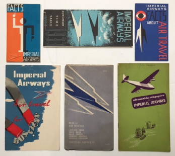
Sold2017Imperial Airways, six publicity booklets including MapImperial Airways, six publicity booklets including Map of European Air Routes, folding page artwork by Edward Bawden, 1933; European Timetable with cover design by Kauffer, 1933; Facts about Air TraveSee Sold Price
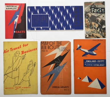
Sold2017Imperial Airways, six publicity booklets including MapImperial Airways, six publicity booklets including Map of the Air Route Cairo-Capetown, folding page artwork by Edward Bawden, coiver by Lee-Elliott 1934-5; European Timetable with cover design by LeeSee Sold Price
Sold2021Color pictorial bird's-eye airline route maps 1929Heading: (Aviation - pictorial route maps) Author: Title: Western Air Express: Travel by Air, Speed - Comfort - Dependability Place Published: [California?] Publisher:Western Air Express Date PuSee Sold Price
Sold20181978 Hawaiian Airline Pictorial Map of Hawaii -- HawaiiTitle/Content of Map: 1978 Hawaiian Airline Pictorial Map of Hawaii -- Hawaii Date Printed: 1978 Cartographer: Hawaiian Airline Size: 12 x 18 in. A very nice pictorial map of Hawaii with air routes ofSee Sold Price
Sold2020c 1920 s TRAVEL MAP ROUTES to YOSEMITE NATIONAL PARK byc 1920 s TRAVEL MAP ROUTES to YOSEMITE NATIONAL PARK by CALIFORNIA AUTO ASSOC. Vintage Circa 1920s Travel Map and Guide; "ROUTES to YOSEMITE NATIONAL PARK". Copyright by California State Automobile AsSee Sold Price
Sold2023Louisville & Nashville Railroad Posters [166764]14 large L & N Railroad poster calendars, each with a map of the routes, circa late 1940s-1960s. Overall size 22 x 28, each with crude plastic frames. Each poster at least two different colors printedSee Sold Price
Sold2018Air France. Large World Map Airways Route Poster.Masse, Jean. Air France. Large World Map Airways Route Poster. Paris: R. Graindorge/Perceval, ca. 1961. Color map of the world detailing the airline's routes. Linen backed. 45 ½ x 81". Small browSee Sold Price
May 09Rail & Road Auctions1882 New York, Ontario and Western / New York West Shore and Buffalo Railroad Map$40
5 hrs LeftTrillium Antique Prints & Rare BooksSlaney - Original Watercolor of Cardinal (or Virginian Nightingale)$35(1 bid)
8 hrs LeftRenew GalleryCirca 1815 Engraved Map A Plan of the Grand of the New Townships on the Grand or Ottawa River$100
1 day LeftWinter Park GalleryAntique Persian Kashan Mohtasham handwoven oversize carpet 12 .5 by 18.11$20,000


![1930 Japanese Mainichi Newspaper World Air Route: Title: 1930 Japanese Mainichi Newspaper World Air Route Pictorial Map -- Conquer Sky Sugoroku [World Air Route Map] Cartographer: Mainichi Newspaper Year / Place: 1930, Osaka Map Dimension (in.): 26.8](https://p1.liveauctioneers.com/5584/187575/94368587_1_x.jpg?height=310&quality=70&version=1607465981)


![Color pictorial bird's-eye airline route maps 1929: Heading: (Aviation - pictorial route maps) Author: Title: Western Air Express: Travel by Air, Speed - Comfort - Dependability Place Published: [California?] Publisher:Western Air Express Date Pu](https://p1.liveauctioneers.com/642/204898/103985846_1_x.jpg?height=310&quality=70&version=1621652446)


![Louisville & Nashville Railroad Posters [166764]: 14 large L & N Railroad poster calendars, each with a map of the routes, circa late 1940s-1960s. Overall size 22 x 28, each with crude plastic frames. Each poster at least two different colors printed](https://p1.liveauctioneers.com/2699/311018/166407876_1_x.jpg?height=310&quality=70&version=1701193734)


![[Maps] American Atlas, Folio (1 of 14)](https://p1.liveauctioneers.com/3532/326332/175680379_1_x.jpg?height=282&quality=70&version=1713151485)


