Sold20181978 Hawaiian Airline Pictorial Map of Hawaii -- HawaiiTitle/Content of Map: 1978 Hawaiian Airline Pictorial Map of Hawaii -- Hawaii Date Printed: 1978 Cartographer: Hawaiian Airline Size: 12 x 18 in. A very nice pictorial map of Hawaii with air routes ofSee Sold Price
Sold2017VINTAGE 1960's HAWAIIAN AIRLINES MAP OF HAWAII, GOODVINTAGE 1960's HAWAIIAN AIRLINES MAP OF HAWAII, GOOD VINTAGE CONDITION, FRAMED SIZE 16.75" X 12.5", SKU7540See Sold Price
Sold2018Vintage Hawaiian Airline Route Map of Hawaii, 1953Title/Content of Map: 1953 Hawaiian Airline Route Map of Hawaii -- Hawaiian Airline Map of the State of Hawaii Date Printed: 1953 Cartographer: Hawaiian Airline Size: 9.2 x 21 in This is a very nice mSee Sold Price
Sold20231950s Hawaiian Airline Route Map of Hawaii -- Hawaiian Airline Map of the State of HawaiiTitle: 1950s Hawaiian Airline Route Map of Hawaii -- Hawaiian Airline Map of the State of Hawaii Cartographer: Hawaiian Airline Year / Place: mid 1950s Map Dimension (in.): 9.2 x 24 in This is a verySee Sold Price
Sold2018Hawaiian Airlines "See All Hawaii" Map and BrochureHawaiian Airlines "See All Hawaii" map and brochure.ÂSee Sold Price
Sold2021[HAWAII] Dole Pictorial Map of the Hawaiian Islands.[HAWAII] Dole Pictorial Map of the Hawaiian Islands. 1937. Offset lithograph. Scarce pre-war pictorial map of the islands, filled with vignettes of the natural and man-made landmarks, modes of transpoSee Sold Price
Sold20231937 color pictorial map of Hawaiian IslandsHeading: (Hawaii) Author: Title: The Dole Map of the Hawaiian Islands, U.S.A.: Being a descriptive portrayal of the history, transportation, industries and geography of the Territory of Hawaii, U.S.ASee Sold Price
Sold20221960 Hawaiian Airlines Pictorial Route Map -- The Hawaiian IslandsTitle: 1960 Hawaiian Airlines Pictorial Route Map -- The Hawaiian Islands Cartographer: Hawaiian Airlines Year / Place: 1960 Map Dimension (in.): 8.9 X 20.2 in This is an attractive pictorial airlineSee Sold Price
Sold20231938 R Taylor White Pictorial Map of Hawaii and Samoa -- Territory of Hawaii [with] SamoaTitle: 1938 R Taylor White Pictorial Map of Hawaii and Samoa -- Territory of Hawaii [with] Samoa Cartographer: Ruth Taylor White Year / Place: 1938, Boston Map Dimension (in.): 11.6 x 8.5 in. This isSee Sold Price
Sold20201938 R Taylor White Pictorial Map of Hawaii and SamoaTitle: 1938 R Taylor White Pictorial Map of Hawaii and Samoa -- Territory of Hawaii [with] Samoa Cartographer: Ruth Taylor White Year/Place: 1938, Boston Size: 11.6 x 8.5 in. Description: This is RuthSee Sold Price
Sold20181938 R Taylor White Pictorial Map of Hawaii and SamoaTitle/Content of Map: 1938 R Taylor White Pictorial Map of Hawaii and Samoa -- Territory of Hawaii [with] Samoa Date Printed: 1938, Boston Cartographer: Ruth Taylor White Size: 11.6 x 8.5 in. This isSee Sold Price
Sold2018Hawaii Hawaiian IslandsTitle/Content of Map: Hawaii Hawaiian Islands Date: 1901 Cartographer: DONN, JOHN M./W.D. ALEXANDER/WALTER E. WALL/C.J. LYONS/J.S. EMERSON et al. Size: 34.4 X 37.7 "Primary triangulation by W.D. AlexaSee Sold Price
Sold2021Ruth Taylor White Hawaii Pictorial Maps (4)Island of Hawaii. Maui. Oahu. Kauai. Set of 4 Cartographs. Printed by The Paradise of the Pacific for the Hawaii Tourist Bureau, Honolulu. C. 1935. Ex library..See Sold Price
Sold2024Antique Hawaiian Islands Government Survey Maps (Set of 6)Lot of 6 antique Hawaiian governmental survey maps (Hawaii, Lanai, Kaho'olawe, Maui, Moloka'I, Oahu, and the full island chain), signed by W.A.Wall. Framed w/ glass and single matted. (14"H 11.5"W 1"DSee Sold Price
Sold2018Map of Hawaii. United Airlines. Our Little Corner ofMap of Hawaii. United Airlines. Our Little Corner of the World. Archar, 1979. An overview of the main island, illustration by Kim Forrest. Linen backed. 24 x 33". Short repaired tears and minor lossesSee Sold Price
Sold20211865 Hawaiian Islands Pacific Islands Kamehameha1865 Hawaiian Islands Pacific Islands Kamehameha Portraits EARLY HAWAII MAP Rufus Anderson’s “The Hawaiian Islands” is a 19th-century account of the Pacific islands covering the origin of the isSee Sold Price
Sold20171881 Hawaii Government Map of Oahu -- Oahu HawaiianTitle/Content of Map: 1881 Hawaii Government Map of Oahu -- Oahu Hawaiian Islands Date Printed: 1,881 Cartographer: Hawaii Government Surveys Size: 26.5 x 34.9 in. This large, detailed map of Oahu froSee Sold Price
Sold2023Northwest Orient Airlines / Hawaii. Circa 1960s. A smiling ...Northwest Orient Airlines / Hawaii. Circa 1960s. A smiling Hawaiian woman gestures toward the viewer, holding a lei. 29 ¼ x 20 ½”. Linen backed. Few spots of restoration in lower corneSee Sold Price
Sold2018Hawaii. Aloha Airlines.Hawaii. Aloha Airlines. 1980s. Colorful map of the islands of Hawaii with illustrations of sea life, an airplane, flora, and a woman in bikini. Linen backed. 23 x 35". A.See Sold Price
Sold2022[HAWAII]. [TRAVEL EPHEMERA]. A group of ephemera from hotel...[HAWAII]. [TRAVEL EPHEMERA]. A group of ephemera from hotels, cruise lines, and airlines, all which service Hawaii and the Pacific. Included: [HAWAIIAN AIRLINES]. Black and white photo of a passengerSee Sold Price
Sold2019Map & view of Hawaii, c.1785Heading: (Hawaii) Author: Title: French map of the Hawaiian Islands & view of Karakakooa, framed together. Place Published: Paris Publisher: Date Published: c.1785 Description:See Sold Price
Sold2022[HAWAII]. Group of 5 airline posters. Circa 1970s/80s. Trav...[HAWAII]. Group of 5 airline posters. Circa 1970s/80s. Travel poster advertisements for Canadian Pacific Airlines, Hawaiian Airlines, and United Airlines. Largest 40 x 25”. Unbacked. Scattered cSee Sold Price
Sold2022Three Antique Hawaiian Maps, US Government3 1920s Hawaiian Maps. Island Of Oahu Map Approximately 47.1875 x 36.5 in. Hawaiian Islands Approximately 45.875 x 35.125 in. Hawaii To Oahu Approximately 46.4375 x 35.5625 in.See Sold Price
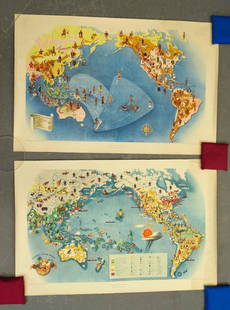
Sold2021Covarrubias Pacific Asia Pictorial Maps (2)Maps of the Pacific, Golden Gate International Exposition. NY, 1942. Miguel Covarrubias (1904-1957). 2 Maps: Peoples and Economy. Australia, Hawaii, Asia, Americas. .See Sold Price
5 days LeftJasper521970s Hawaiian Airlines Pictorial Route Map -- Hawaiian Airlines Map of the Hawaiian Islans$35
6 days LeftJasper52HAWAII HISPANIOLA. Hawaiian Isles; Haiti San Domingo Dominican Republic 1898 map$20
May 12Hoch LTD.John Severson (American, 1933 - 2017) Signed Surf Art Oil on Canvas Painting, Hawaiian Mountain View$50
May 13Donny Malone AuctionsTed Mundorff, Hawaii, Botanical Flower Study, Airbrush Artwork, Signed Framed$10
2 days LeftTremont Auctions4 Earl M. Washington woodblock prints. 1) Hula girl pencil signed and dated. 1937. 2) Subway sheeps.$100


![[HAWAII] Dole Pictorial Map of the Hawaiian Islands.: [HAWAII] Dole Pictorial Map of the Hawaiian Islands. 1937. Offset lithograph. Scarce pre-war pictorial map of the islands, filled with vignettes of the natural and man-made landmarks, modes of transpo](https://p1.liveauctioneers.com/928/200564/101543113_1_x.jpg?height=310&quality=70&version=1618323144)


![1938 R Taylor White Pictorial Map of Hawaii and Samoa -- Territory of Hawaii [with] Samoa: Title: 1938 R Taylor White Pictorial Map of Hawaii and Samoa -- Territory of Hawaii [with] Samoa Cartographer: Ruth Taylor White Year / Place: 1938, Boston Map Dimension (in.): 11.6 x 8.5 in. This is](https://p1.liveauctioneers.com/5584/274166/143946169_1_x.jpg?height=310&quality=70&version=1673389176)
![1938 R Taylor White Pictorial Map of Hawaii and Samoa: Title: 1938 R Taylor White Pictorial Map of Hawaii and Samoa -- Territory of Hawaii [with] Samoa Cartographer: Ruth Taylor White Year/Place: 1938, Boston Size: 11.6 x 8.5 in. Description: This is Ruth](https://p1.liveauctioneers.com/5584/169916/85621317_1_x.jpg?height=310&quality=70&version=1591137604)
![1938 R Taylor White Pictorial Map of Hawaii and Samoa: Title/Content of Map: 1938 R Taylor White Pictorial Map of Hawaii and Samoa -- Territory of Hawaii [with] Samoa Date Printed: 1938, Boston Cartographer: Ruth Taylor White Size: 11.6 x 8.5 in. This is](https://p1.liveauctioneers.com/5584/117342/60336911_1_x.jpg?height=310&quality=70&version=1520389291)


![[HAWAII]. [TRAVEL EPHEMERA]. A group of ephemera from hotel...: [HAWAII]. [TRAVEL EPHEMERA]. A group of ephemera from hotels, cruise lines, and airlines, all which service Hawaii and the Pacific. Included: [HAWAIIAN AIRLINES]. Black and white photo of a passenger](https://p1.liveauctioneers.com/928/265343/138522942_1_x.jpg?height=310&quality=70&version=1666130009)

![[HAWAII]. Group of 5 airline posters. Circa 1970s/80s. Trav...: [HAWAII]. Group of 5 airline posters. Circa 1970s/80s. Travel poster advertisements for Canadian Pacific Airlines, Hawaiian Airlines, and United Airlines. Largest 40 x 25”. Unbacked. Scattered c](https://p1.liveauctioneers.com/928/255324/132835924_1_x.jpg?height=310&quality=70&version=1658268357)