Sold2022Alexis Hubert Jaillot and Nicolas Sanson - Map of the Grand Duchy of Moscow, Etching, 1708.Alexis Hubert Jaillot (French, 1632-1712) and Nicolas Sanson (French, 1600-1667) - Map of the White Russia or the Grand Duchy of Moscow, Etching, 1708. Title: Les Estats du Czaar de Russie Blanche ouSee Sold Price
Sold2018RARE 17TH C. SANSON MAP OF LUXEMBOURGAlexis-Hubert Jaillot (c. 1632-1712); Nicolas Sanson (1600-1667) "Le Duche de Luxembourg Divise en Quarter Walon et Allemand....", hand colored engraving, published 1700 from earlier plates, Paris, frSee Sold Price
Sold2020Nicolas Sanson Map of Morea Greece 1692Nicolas Sanson (1600-1677), "La Moree et les Isles de Zante, Cafalonie, Ste Maure, Cerigo, &c." Paris: Hubert Jaillot, 1692. This hand-colored map depicts Morea, the southern part of Greece, with theSee Sold Price
Sold2021Antique French Regional MapLa Lorraine qui Comprend les Duches de Lorraine et de Bar. Nicolas Sanson -- Charles Hubert Jaillot, Paris, 1700. Engraving, uncolored.. 21" x 28".See Sold Price
Sold2018[JAILLOT] MAP OF HUNGARY & SURROUNDINGS'Le Royaume De Hongrie Et Les Estats qui en ont este sujets....La Partie Septentrionale De La Turquie en Europe, by Alexis-Hubert Jaillot (ca. 1632-1712) and Guillaume Sanson (1633-1703), engraving wiSee Sold Price
Sold2023Framed Map of the Ottoman Empire, 1696Print of 17th century map, originally engraved by Alexis-Hubert Jaillot (1632-1712, France), depicting the Ottoman Empire circa 1696 Provenance: a San Antonio, Texas collection We happily provide seSee Sold Price
Sold2020Nicolas Sanson Map of AsiaNicolas Sanson (1600-1667) "L'Asie divisee en ses Principales Regions, et ou se peuvent voir l'estendue, Des Empires, Monarchies, Royaumes, et Estats," Paris: Jaillot, ca. 1719. Hand colored map of AsSee Sold Price
Sold2016Hubert Jaillot Sanson 1692 Map of ItalyFrame: 38" x 26" image sight: 36.25" x 24.25"See Sold Price
Sold2017Alexis Hubert Jaillot (French 1632-1712) map of Asia,Alexis Hubert Jaillot (French 1632-1712) map of Asia, "L' Asie, Distinquee en ses principales Parties. 1687", framed and glazed, "L'asie divisee en ses Principales Regions, et ousepeut voir l'estendueSee Sold Price
Sold2019Alexis Hubert Jaillot (French 1632-1712) - Map of Asia,Alexis Hubert Jaillot (French 1632-1712) - Map of Asia, 1692. L'Asie Divisee en ses Principales Map, 1692. Map of Asia. 57x87cm. Folds, tears.See Sold Price
Sold20241694 Alexis-Hubert Jaillot Highly Detailed Map Of ItalyMap of Italy, the Adriatic, Mediterranean and contiguous islands, including Corsica, Sardinia and SicilySee Sold Price
Sold2016CARTE PARTICULIERE DE VIRGINIE, MARYLAND, PENNSYLVANIA;CARTE PARTICULIERE DE VIRGINIE, MARYLAND, PENNSYLVANIA; ALEXIS-HUBERT JAILLOT (1632-1712), ENGRAVED HAND COLORED MAP, AMSTERDAM AND PAIRIS, PIERRE MORTIER, C.1693-1710 (AN IMPORTANT CHART OF THE MID-ASee Sold Price
Sold20191695 KINGDOM OF PORTUGAL AND THE ALGARVES MAPColored 1695 map of Portugal "Le Royaume De Portugal et des Algarves" by Alexis Hubert Jaillot (1632-1712). Measure 39" x 30.5" w/ frame.See Sold Price
Sold2023Jaillot Map of South America with Exceptional ColorJAILLOT, Alexis Hubert (1632-1712). L'Amerique Meridionale. Engraved map with exceptional original color. Paris, c. 1691. 24 3/4" x 36 1/4" sheet. Large format map of South America, based upon earlierSee Sold Price
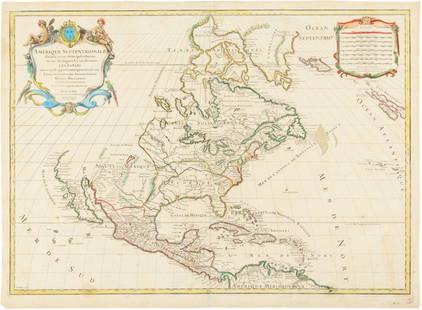
Sold2015Map of North America 1719Heading: (North America) Author: Sanson, Nicolas/ Hubert Jaillot Title: Amerique Septentrionale divisée en ses Principales Parties, ou sont distingués les uns des autres les Estats suivant quils appSee Sold Price
Sold2019Russia.- Jaillot (Alexis-Hubert) La Russie Blanche ouRussia.- Jaillot (Alexis-Hubert) La Russie Blanche ou Moscovie Divisee Suivant l'Estendue Des Royaumes Duches, large format map of Russia, extending from the Baltic and Black Seas to Grande Tartarie aSee Sold Price
Sold2021LE ROYAUME DE HONGRIE, ET LES ESTATS QUI ONT ESTÉTitle/Content of Map: LE ROYAUME DE HONGRIE, ET LES ESTATS QUI ONT ESTÉ SUJETS ET DEPENDANS DE SA COURONNE ...’ Cartographer: Nicolas Sanson Publisher: Published by Hubert Jaillot from the plate bySee Sold Price
Sold2020Grp: 5 Maps of Africa Jaillot DelisleGroup of five maps of Africa. Includes Hubert Jaillot (1632-1712), "L'Afrique divisee suivant l'estendue de ses principales parties, ou sont distingues les uns des autres les Empires, Monarchies, RoyaSee Sold Price
Sold2024Sanson & Jaillot "Le Royaume de Naples Divisé en Douze Provinces"Map was originally created by Nicholas Sanson d'Abbeville and published by Hubert Jaillot in "Atlas Nouveau" in Paris in 1692See Sold Price
Sold2017Three maps of Africa and Middle Eastcomprising: 1) Nicolas Sanson, "Haute Ethiopie …" Paris, 1655, engraving, about 16 X 20 in., p.m.; 2) after Sanson, "Description de l'Empire du Sophi des Perses," Paris, c,1730, engraving with old oSee Sold Price
Sold2020Hubert Jaillot Map South America 1719Hubert Jaillot (1632-1712), "Amerique Meridionale divisee en ses pricipales Parties ou sont distingues les uns des autres les Estats suivant qu'ils appartiennent presentement aux Francois, Castillans,See Sold Price
Sold2024Nicolas Sanson - Map of Asia / Asia divided into its Principal RegionsCopper engraving, 1600s/1700s, "Asia divided into its Principal Regions." By Mr. Sanson, Geographer Ordinary to the King. Size: 58 cm x 88 cm.See Sold Price
Sold2021Alexis-Hubert Jaillot, Le Duche de Brabant, 1692Title: Le Duche de Brabant, qui comprend les Quartiers de Louvain, Brusselles, Anvers et Bosleduc... Cartographer: Alexis-Hubert Jaillot (1632-1712) Copper plate engraving, 1692-93.Two plates (joinedSee Sold Price
Sold2021Alexis-Hubert Jaillot, Duche de Gueldre, 1692Title: La Veluwe, La Betuwe et Le Comte de Zutphe dans le Duche de Gueldre...Cartographer: Alexis-Hubert Jaillot (1632-1712) Copper plate engraving, 1692-93.Two plates (joined) 22 x 29 7/8" (56 x 75.See Sold Price
5 days LeftTrillium Antique Prints & Rare BooksSanson - Map of Canada or New France with the Great Lakes$75
23 hrs LeftJasper521693 Jaillot Map of the Adriatic Sea and Much of Italy -- Le Golfe de Venise, Avec ses Principaux$500
5 days LeftTrillium Antique Prints & Rare BooksSanson - Map of Florida (encompassing most of Southeast North America)$75(1 bid)
5 days LeftTrillium Antique Prints & Rare BooksSanson - Map of the British Isles (Ireland, Scotland, England)$75
21 hrs LeftJasper52Antique French Engraving Felix Delamarche set of celestial and solar system 1838$60
23 hrs LeftJasper521652 Sanson Map of Parts od Southeast Asia -- Les Isles de la Sonde. Entre Lesquelles sont Sumatra,$200
23 hrs LeftJasper521683 Sanson Map of the Caribbean -- Les Isles Antilles, &c Entre Lesquelles sont les Lucayes, et les$170
21 hrs LeftJasper52Large Antique French map GERMAN EMPIRE 1792 colored by POIRSON engraver Basset$170
23 hrs LeftJasper521719 Chatelain Map of Russian Empire -- Carte Generale des Etats du Czar Empereur de Moscovie…$320


![[JAILLOT] MAP OF HUNGARY & SURROUNDINGS: 'Le Royaume De Hongrie Et Les Estats qui en ont este sujets....La Partie Septentrionale De La Turquie en Europe, by Alexis-Hubert Jaillot (ca. 1632-1712) and Guillaume Sanson (1633-1703), engraving wi](https://p1.liveauctioneers.com/522/124271/63207925_1_x.jpg?height=310&quality=70&version=1530290718)