Sold2022Alexis Hubert Jaillot and Nicolas Sanson - Map of the Grand Duchy of Moscow, Etching, 1708.Alexis Hubert Jaillot (French, 1632-1712) and Nicolas Sanson (French, 1600-1667) - Map of the White Russia or the Grand Duchy of Moscow, Etching, 1708. Title: Les Estats du Czaar de Russie Blanche ouSee Sold Price
Sold2018RARE 17TH C. SANSON MAP OF LUXEMBOURGAlexis-Hubert Jaillot (c. 1632-1712); Nicolas Sanson (1600-1667) "Le Duche de Luxembourg Divise en Quarter Walon et Allemand....", hand colored engraving, published 1700 from earlier plates, Paris, frSee Sold Price
Sold2020Nicolas Sanson Map of Morea Greece 1692Nicolas Sanson (1600-1677), "La Moree et les Isles de Zante, Cafalonie, Ste Maure, Cerigo, &c." Paris: Hubert Jaillot, 1692. This hand-colored map depicts Morea, the southern part of Greece, with theSee Sold Price
Sold2021Antique French Regional MapLa Lorraine qui Comprend les Duches de Lorraine et de Bar. Nicolas Sanson -- Charles Hubert Jaillot, Paris, 1700. Engraving, uncolored.. 21" x 28".See Sold Price
Sold2018[JAILLOT] MAP OF HUNGARY & SURROUNDINGS'Le Royaume De Hongrie Et Les Estats qui en ont este sujets....La Partie Septentrionale De La Turquie en Europe, by Alexis-Hubert Jaillot (ca. 1632-1712) and Guillaume Sanson (1633-1703), engraving wiSee Sold Price
Sold2016CARTE PARTICULIERE DE VIRGINIE, MARYLAND, PENNSYLVANIA;CARTE PARTICULIERE DE VIRGINIE, MARYLAND, PENNSYLVANIA; ALEXIS-HUBERT JAILLOT (1632-1712), ENGRAVED HAND COLORED MAP, AMSTERDAM AND PAIRIS, PIERRE MORTIER, C.1693-1710 (AN IMPORTANT CHART OF THE MID-ASee Sold Price
Sold2021Alexis-Hubert Jaillot, La Franche Comte, 1692Title: La Franche Comte divisee en trois grands balliages scavoir D'Amont, D'Aval, et du Milieu ou de Dole.Cartographer: Alexis-Hubert Jaillot (1632-1712) Copper plate engraving, 1692-93.Two plates (See Sold Price
Sold2023Jaillot Map of South America with Exceptional ColorJAILLOT, Alexis Hubert (1632-1712). L'Amerique Meridionale. Engraved map with exceptional original color. Paris, c. 1691. 24 3/4" x 36 1/4" sheet. Large format map of South America, based upon earlierSee Sold Price
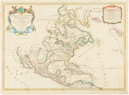
Sold2015Map of North America 1719Heading: (North America) Author: Sanson, Nicolas/ Hubert Jaillot Title: Amerique Septentrionale divisée en ses Principales Parties, ou sont distingués les uns des autres les Estats suivant quils appSee Sold Price
Sold2019Russia.- Jaillot (Alexis-Hubert) La Russie Blanche ouRussia.- Jaillot (Alexis-Hubert) La Russie Blanche ou Moscovie Divisee Suivant l'Estendue Des Royaumes Duches, large format map of Russia, extending from the Baltic and Black Seas to Grande Tartarie aSee Sold Price
Sold2018AFTER NICOLAS SANSON (FRENCH, 1600-1667) MAP OF NORTHAFTER NICOLAS SANSON (FRENCH, 1600-1667) MAP OF NORTH AMERICA, hand-colored, on laid paper, title in cartouche to upper left corner lettered "NORTH AMERICA / Divided into it's Principall Parts / whereSee Sold Price
Sold2020A LOUIS XIV MAP, "L'Amerique Septentrionale," HUBERTA LOUIS XIV MAP, "L'Amerique Septentrionale," HUBERT JAILLOT, PARIS, 1696, hand colored engraving on paper, "Divisée en ses principals parties, ou sont distingués les uns des autres Les Estats suivaSee Sold Price
Sold2016Hubert Jaillot. Amerique Septentrionale diviséeHubert Jaillot. Amerique Septentrionale divisée en ses principales parties<See Sold Price
Sold2016Hand Colored Engraved Map,Hubert JaillotAfter Hubert Jaillot (1632-1712) "Amerique Septentrionale divisee on ses principales parties". Hand colored engraved map of North American under the French power of Louis XIV. [Sight: 22 1/2" H x 35"See Sold Price
Sold20241719 Map of Colonial era North America, by Sanson - JaillotTitle: 1719 Map of Colonial era North America, by Sanson - Jaillot Date/Period: 1719 Materials: Copperplate engraved Size: 25 1/2 x 18” This map is a rare and valuable map of history, showing NoSee Sold Price
Sold2024Two Unframed Maps by Nicholas Sanson(French, 1600-1667) One of La Bretagne, with Hubert Iaillot, and one of Le Royaume de France with Pierre Mariette. Together with a map of Governement de Dauphine by Gerhard Valk. 3 pieces Tears, creasSee Sold Price
Sold2020LOUIS ICART (FRENCH, 1888-1950).Etching. "Grand Eve". 1934. Signed lower right. From a New York, NY collection. - Dimensions: 31" high x 20" wideSee Sold Price
Sold2016JOAN MIRO "LE GRAND ORDONNATEUR" SIGNED ETCHINGJoan Miro (Spanish, 1893-1983) "Le Grand Ordonnateur" color etching with aquatint and carborundum edition HC circa 1969. (Aside from an edition of 75) Signed lower right in pencil, Miro. Ht: 46.5" WidSee Sold Price
Sold2018India.- Joseph (Charles) Map of the Grand Trunk RoadIndia.- Joseph (Charles) Map of the Grand Trunk Road from the Karamnassa to the Sutledge, Part Second, from Agra to Ferozepoor, large folding road map of one of the oldest and longest trade routes linSee Sold Price
Sold2016Print, Joan Miro, Le Grand OrdonnateurJoan Miro (Spanish/French, 1893-1983), "Le Grand Ordonnateur," 1969, etching with aquatint printed in colors with carborundum, pencil signed lower right, edition "HC", image: 38.5"h x 23"w, sheet: 41"See Sold Price
Sold2022Atlas. SANSON D'ABBEVILLE. L'Europe, l'Asie, L'Afrique, l'Amérique en plusieurs cartes et enSANSON D'ABBEVILLE, Nicolas. L'Europe, l'Asie, L'Afrique, l'Amérique en plusieurs cartes et en divers traités de Géographie et d'Histoire.Paris, Chez l'Autheur 1683In-4to. 220x175 mm. LSee Sold Price
Sold2023[MAP]. FRY & JEFFERSON. A Map of the Most Inhabited Part of Virginia. 1775. FIRST PRINTED MAP OF[MAPS & ATLASES]. FRY, Joshua (1699-1754) and Peter JEFFERSON (1708-1757). A Map of the Most Inhabited Part of Virginia containing the whole Province of Maryland with Part of Pensilvania, New JersSee Sold Price
Sold2024Circa 1815 Engraved Map A Plan of the Grand of the New Townships on the Grand or Ottawa RiverCirca 1815 A Plan of the Grand of the New Townships on the Grand or Ottawa River. London 1815. Engraved map by J. Walker. From Joseph Bouchette's book. "Joseph Bouchette's books played an important paSee Sold Price
Sold2017Robert Morden - English Plantations in AmericaRobert Morden (d. 1703) and William Berry (fl. 1669-1708) makers A New Map of the English Plantations in America both Continent and Ilands Shewing their true Situation and distance from England or oneSee Sold Price
May 09Hunt and Peck Estate Services, Inc.Sanson & Jaillot "Le Royaume de Naples Divisé en Douze Provinces"$200
May 09Hunt and Peck Estate Services, Inc.1694 Alexis-Hubert Jaillot Highly Detailed Map Of Italy$200(1 bid)
7 days LeftTiberius AuctionsFrom the property of the Grand Duchy of Hesse, Anton Raffael Mengs, Aussig 1728 - 1779 Rome,€1,000
May 09Hunt and Peck Estate Services, Inc.Jacques Nicolas Bellin Map Of Western Part Of New France Or Canada$200(1 bid)
5 mins LeftWillow Creek Coin & CollectiblesHubert Von Herkommer (1849-1914) "Our Messenger", c. 1900.$20
May 17Heritage Auctions82061: Prince Nikita Alexandrovich: A No. 2 Bulls-Eye K$500
May 17Heritage Auctions82004: Empress Maria Feodorovna: An Imperial Fabergé F$15,000
4 days LeftJay Anderson AuctionCirca 1875 American Inlaid Walnut 1/2 Commode probably made by Berkey & Gay furniture Grand Rapids$650(3 bids)


![[JAILLOT] MAP OF HUNGARY & SURROUNDINGS: 'Le Royaume De Hongrie Et Les Estats qui en ont este sujets....La Partie Septentrionale De La Turquie en Europe, by Alexis-Hubert Jaillot (ca. 1632-1712) and Guillaume Sanson (1633-1703), engraving wi](https://p1.liveauctioneers.com/522/124271/63207925_1_x.jpg?height=310&quality=70&version=1530290718)


![[MAP]. FRY & JEFFERSON. A Map of the Most Inhabited Part of Virginia. 1775. FIRST PRINTED MAP OF: [MAPS & ATLASES]. FRY, Joshua (1699-1754) and Peter JEFFERSON (1708-1757). A Map of the Most Inhabited Part of Virginia containing the whole Province of Maryland with Part of Pensilvania, New Jers](https://p1.liveauctioneers.com/197/305583/163286504_1_x.jpg?height=310&quality=70&version=1697143109)


