Sold2022Antique 1844 Hand Colored Olney's School Atlas Published by Pratt, Woodford, and Co.This is an antique Olney's School Atlas published in 1844 by Pratt, Woodford and Co of New York. The softbound volume features hand colored maps of regions of the United States and the world. CharmingSee Sold Price
Sold2020With U.S. map showing "maximum" TexasHeading: (Atlas) Author: Olney, J. Title: Olney's School Atlas Place Published: New York Publisher:Pratt, Woodford & Co. Date Published: 1844 Description: With 16 hand-colored coSee Sold Price
Sold2020Olney's Atlas with Independent TexasHeading: (Atlas) Author: Olney, J. Title: Olney's School Atlas Place Published: New York Publisher:Robinson, Pratt & Co. Date Published: 1841 Description: Illustrated with 1See Sold Price
Sold20231847 MAP OF UNITED STATES.Published New York, 1847, by Pratt, Woodford & Co., hand colored engraved map on paper. "Olney's Outline Map for Common Schools and General Use" showing the United States and Territories with correspoSee Sold Price
Sold2018[ATLAS]. OLNEY, Jesse (1798-1872).[ATLAS]. OLNEY, Jesse (1798-1872). A New and Improved School Atlas, to Accompany the Practical System of Modern Geography. New York: Robinson, Pratt & Co, ca 1831. 4to (296 x 240). 12 hand-colored engSee Sold Price
Sold20211844 Mitchell's Ancient Atlas Map Book,Hand ColoredAntique Geography Book, Mitchell's Ancient Atlas 1844. A school instructional book "Containing Maps Illustrating Geography of the Ancient World". Published in Philadelphia by E.H. Butter & Co. DimensSee Sold Price
Sold2023Rare Antique OLNEY'S SCHOOL ATLAS, Maps 1844We have included quality images to show their condition. This lot is located in Boca Raton, Fl and its shipment will be made directly by Artelisted. Shipping insurance is the responsibility of the buySee Sold Price
Sold2017Colton: Antique Map of Mexico, 1871Title/Content of Map: Mexico by Colton Date Printed: 1871 Cartographer: G.W. Colton Material/Medium: Paper Size: 17 1/4" x 14 1/2" Hand colored lithograph. From 'Colton's American Atlas'. Published inSee Sold Price
Sold2017Colton: Antique Map of Mississippi, 1871Title/Content of Map: Colton's Mississippi Date Printed: 1871 Cartographer: G. W. Colton Material/Medium: Paper Size: 13" x 17" Hand colored lithograph. From 'Colton's American Atlas.' Published in NeSee Sold Price
Sold20231844. Southern states by OlneyTitle: 1844. Southern states by Olney Date/Period: 1844 Materials: Steel engraved Size: 19 x 12” 1844. By A. N. Olney. New York. Published in ‘Olney’s School Atlas’. Hand-colorSee Sold Price
Sold2018Colton: Antique Map of South Carolina, 1871Title/Content of Map: South Carolina by Colton Date Printed: 1871 Cartographer: G.W. Colton Material/Medium: Paper Size: 17" x 14" Hand colored lithograph. From 'Colton's American Atlas'. Published inSee Sold Price
Sold2017Colton: Antique Map of Wisconsin, 1871Title/Content of Map: Wisconsin by Colton Date Printed: 1871 Cartographer: G. W. Colton Material/Medium: Paper Size: 17" x 14" Hand colored lithograph. From 'Colton's American Atlas.' Published in NewSee Sold Price
Sold2017Colton: Antique Map of Ohio, 1871Title/Content of Map: Ohio by Colton Date Printed: 1871 Cartographer: G. W. Colton Material/Medium: Paper Size: 17" x 14" Hand colored lithograph. From 'Colton's American Atlas.' Published in New YorkSee Sold Price
Sold2017Colton: Antique Map of Minnesota, 1871Title/Content of Map: Minnesota by Colton Date Printed: 1871 Cartographer: G. W. Colton Material/Medium: Paper Size: 15" x 17" Hand colored lithograph. From 'Colton's American Atlas.' Published in NewSee Sold Price
Sold2023Scarce 1850 RR map of Massachusetts & R. IslandStriking map of Massachusetts and Rhode Island, hand colored by counties, from the exceedingly difficult to obtain New Universal Atlas, published 1853 by Thomas, Cowperthwait & Co.. Highlights railroaSee Sold Price
Sold2021Scarce twp. Map of Kans, Col. & Neb. - 1876Hand-colored, detailed township map of Kansas, Colorado & Nebraska from the very scarce Jones and Hamilton Historical Atlas of the World Illustrated. Atlas published 1876 by Higgins, Bro. & Co. An unuSee Sold Price
Sold2018Simmons "Meet of the Vine Hounds" 1844 PrintWilliam Henry Simmons, British, 1811–1882,"The Meet of the Vine Hounds," 1844, hand-colored engraving, after the painting by Henry Calvert, (British, 1798 - 1869), published by Henry Graves and Co.See Sold Price
Sold2022AfricaTitle: Africa Date: 1837 Cartographer: OLNEY, JESSE Publisher: ROBINSON, PRATT & CO. Description: From Olney's A New and Improved school atlas. Original coloring. Height: 7.3 Width: 9.5 Reserve: $45.0See Sold Price
Sold2022Antique Map Print - Map of Bohemia - Map of Czech Republic - KingdomAntique outline hand colored map from edition of Meyer’s world atlas, edited by Ludwig Ravenstein, published by Bibliographic Institute in 1872. Technique: Engraving. Place: Leipzig, Germany. SSee Sold Price
Sold2017Olney: Map of Europe, 1837Map of Europe. Robinson, Pratt & Co., Olney, Jesse. 1837. From Olney's A New and Improved school atlas. Original coloring. Some light foxing. Quarto – 8.00 H x 9.75 W Inches Please note that this loSee Sold Price
Sold2022Original Antique Map -Pommern Provinz - Map of Bornholm Island Baltic SeaAntique outline hand colored map from edition of Meyer’s world atlas, edited by Ludwig Ravenstein, published by Bibliographic Institute in 1872. Technique: Engraving. Place: Leipzig, Germany. SSee Sold Price
Sold2022Original Antique Map - Mecklenburg-Schwerin - Map of Northern GermanyAntique outline hand colored map from edition of Meyer’s world atlas, edited by Ludwig Ravenstein, published by Bibliographic Institute in 1872. Technique: Engraving. Place: Leipzig, Germany. SSee Sold Price
Sold2022Original Antique Map -Bremen Oldenburg - Map of Bremen OldenburgAntique outline hand colored map from edition of Meyer’s world atlas, edited by Ludwig Ravenstein, published by Bibliographic Institute in 1872. Technique: Engraving. Place: Leipzig, Germany. SSee Sold Price
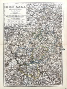
Sold2022Original Antique Map -Hessen Nassau - Map of Furstenthum WaldeckAntique outline hand colored map from edition of Meyer’s world atlas, edited by Ludwig Ravenstein, published by Bibliographic Institute in 1872. Technique: Engraving. Place: Leipzig, Germany. SSee Sold Price
2 days LeftTrillium Antique Prints & Rare BooksMitchell's A New Universal Atlas.. - Volume with 73 Maps$1,000(1 bid)
3 days LeftWorthington GalleriesRare Antique Hand-colored Engraving OFFICERS OF THE BRITISH ARMY, NO. 57$40
2 days LeftTrillium Antique Prints & Rare BooksWebber & Cook, Rare - View in the Island of Cracatoa$500
2 days LeftTrillium Antique Prints & Rare BooksWebber & Cook, Rare - A View in Oheitepeha Bay, in the Island of Otaheite$500
2 days LeftTrillium Antique Prints & Rare BooksWebber & Cook, Rare - A View in the Islands of Pulo Condore$500
2 days LeftTrillium Antique Prints & Rare BooksCarey & Lea's .. American Atlas - Volume with 46 Originally Hand-colored Folio Maps$1,000(1 bid)
2 days LeftTrillium Antique Prints & Rare BooksBraun & Hogenberg, pub. 1575 - View of Cusco, Peru and Mexico$375(4 bids)
2 days LeftTrillium Antique Prints & Rare BooksBraun & Hogenberg, pub. 1575 - View of Jerusalem, Israel$100(1 bid)
2 days LeftTrillium Antique Prints & Rare BooksBraun & Hogenberg, pub. 1575 - View of Ghent, Belgium$100(1 bid)
2 days LeftTrillium Antique Prints & Rare BooksAudubon - American Robin or Migratory Thrush. 142$25(1 bid)
2 days LeftTrillium Antique Prints & Rare BooksBraun & Hogenberg, pub. 1575 - View of Rotterdam, Netherlands$100(1 bid)


![[ATLAS]. OLNEY, Jesse (1798-1872).: [ATLAS]. OLNEY, Jesse (1798-1872). A New and Improved School Atlas, to Accompany the Practical System of Modern Geography. New York: Robinson, Pratt & Co, ca 1831. 4to (296 x 240). 12 hand-colored eng](https://p1.liveauctioneers.com/197/119933/61100813_1_x.jpg?height=310&quality=70&version=1522758048)