Sold2023Atoll of Ebon. Pacific Ocean. Marshall Islands. Sketch map 1886 oldTITLE/CONTENT OF MAP: 'Atoll of Ebon' DATE PRINTED: 1886 IMAGE SIZE: Approx 11.5 x 11.5cm, 4.5 x 4.5 inches (Small) TYPE: Antique engraved sketch map CONDITION: Good; suitable for framing. Please checSee Sold Price
Sold2023Atoll of Menchikoff. Marshall Islands. Kwajalein Atoll. Sketch map 1886TITLE/CONTENT OF MAP: 'Atoll of Menchikoff' DATE PRINTED: 1886 IMAGE SIZE: Approx 9.0 x 11.0cm, 3.5 x 4.25 inches (Small) TYPE: Antique engraved sketch map CONDITION: Good; suitable for framing. PleasSee Sold Price
Sold2019Three Maps by the Hydrographic Office U. S. Navy,Three Maps by the Hydrographic Office U. S. Navy, consisting of "North Pacific Ocean, Marshall Islands, Northern Portion," 1945, H. - 32 in., W. - 50 in.; "France, West Coast, Le Sabe to D'Olonne," anSee Sold Price
Sold2024Isothermals of the Pacific Ocean 1886 old antique vintage map plan chartTITLE/CONTENT OF MAP: 'Isothermals of the Pacific' DATE PRINTED: 1886 IMAGE SIZE: Approx 19.0 x 26.5cm, 7.5 x 10.5 inches (Medium); Please note that this is a folding map. TYPE: Antique engraved colouSee Sold Price
Sold2023PACIFIC OCEAN & ISLANDS. Australasia. Currents. LETTS 1884 old antique mapTITLE/CONTENT OF MAP: 'The Pacific Ocean; Inset map of British Isles' DATE PRINTED: 1884 IMAGE SIZE: Approx 34.5 x 41.5cm, 13.75 x 16.25 inches (Large) TYPE: Antique colour atlas map CONDITION: Good;See Sold Price
Sold2018Sketch of South Farallon Island Pacific OceanTitle/Content of Map: Sketch of South Farallon Island Pacific Ocean Date Printed: 1855 Cartographer: BACHE, A.D. Size: 13.3X12.8 Engd. by G.B. Metzeroth & a. Peterson. Sketch shows light house and 3 vSee Sold Price
Sold202370304: A Marshall Islands Navigation Map Micronesia, 1A Marshall Islands Navigation Map Micronesia, 19th century Constructed of coconut palm leaf midribs and shells. Such maps or charts were for navigating specific atolls and islands in MicrSee Sold Price
Sold2022(CAPTAIN COOK.) John Webber, et al. [Atlas to] A Voyage to the Pacific Ocean.(CAPTAIN COOK.) John Webber, et al. [Atlas to] A Voyage to the Pacific Ocean. 2 engraved maps, 61 engraved plates. Folio, 22½x17 inches, contemporary boards, well-worn and partly disbound; dampstSee Sold Price
Sold2024Abraham Ortelius (Belgian 1527 - 1598)Abraham Ortelius (Belgian 1527 - 1598) "Maris Pacifici", circa 1603 Hand Colored map engraving of the Pacific Ocean 14" x 20" Condition: aging, yellowing to paper, undulation, center folds, some fadinSee Sold Price
Sold2023Gorgeous 18th C. Hawaiian Kou Wood Bowl, Old RepairsNorth Pacific, Hawaiian Islands, ca. 18th century CE. A grandiose and gorgeous calabash bowl, skillfully hand-carved from wood of the kou tree - an inherently beautiful Hawaiian hardwood with a warm gSee Sold Price
Sold202318th C. Hawaiian Kou Wood Calabash Bowl Old RepairsNorth Pacific, Hawaiian Islands, ca. 18th century CE. A dazzling bowl of stable, round-bottomed form exhibiting sumptuous caramel, coffee, wheat, and mahogany hues from the wood of the kou tree - an iSee Sold Price
Sold2023De Eylanden van Pehou' by VAN KEULEN. Penghu Islands Taiwan. VOC chart 1753 mapTitle: De Eylanden van Pehou' by VAN KEULEN. Penghu Islands Taiwan. VOC chart 1753 map Description: De Eylanden van Pehou' by Johannes van Keulen (1753). Early 18th century Dutch sea chart with old coSee Sold Price
Sold2024Joseph Yoakum. Junction Point of South Atlantic Ocean and South Pacific Ocean.Joseph Yoakum. (1891-1972). The Junction Point of South Atlantic Ocean and South Pacific Ocean Near Delfulgo, Argentina and Pairgona. Signed and titled. Ink, colored pencil and graphite on paper. MastSee Sold Price
Sold2022VANCOUVER, George (1757-1798). A Voyage of Discovery to the North Pacific Ocean and Round the World.VANCOUVER, George (1757-1798). A Voyage of Discovery to the North Pacific Ocean and Round the World. London: G. G. 7 J. Robinson, 1798.   4 volumes, comprising: text, 3 volumes, 4to (295 x 233 mmSee Sold Price
2023Vancouver's A Voyage of Discovery to the North Pacific Ocean - 6 Octavo Volumes, 1 Folio AtlasGeorge Vancouver's A Voyage of Discovery to the North Pacific Ocean, and Round the World; in which the Coast of North-west America has been carefully examined and accurately surveyed undertaken by HisSee Sold Price
Sold2022ARROWSMITH, AARON. Chart of the Pacific Ocean.ARROWSMITH, AARON. Chart of the Pacific Ocean. Large engraved navigational chart of the coastlines of Russia, Japan, Korea, China, the Philippines, Indonesia, and Australia. 73¼x31½ inches oSee Sold Price
Sold2017(VIII) VOLUMES "COOK'S VOYAGES" and PORTFOLIO 17W.Strahan and T.Cadell, London, 1773. Hardcover. Book Condition: Fine. Greatest of All Pacific Ocean Explorers, Bedrock Set and Basis for any Collection on the Pacific Voyage One An Account of the VoySee Sold Price
Sold20177.5mm-16.2mm Pacific Coral Necklace W/18K & Diam.7.5mm-16.2mm Pacific Ocean Coral 20" Graduated Necklace W/Solid 18K White Gold & Diamond Clasp RARE - This stunning piece is made of red and bi-color red 7.5mm-16.2mm Pacific Ocean Coral. This is theSee Sold Price
Sold2021Cook's 3rd Voyage with atlas plates bound inHeading: Author: Cook, James and James King Title: A Voyage to the Pacific Ocean. Undertaken, by the Command of His Majesty, for Making Discoveries in the Northern Hemisphere. Performed under the DirSee Sold Price
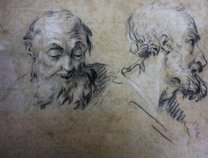
Sold2016Falconet(after); 19thC. Charcoal SketchCharcoal on paper. Sketch - Old Man. After Falconet; 8.75in. X 11.75in.(image size)See Sold Price
Sold2015CHINESE SOAPTONE CARVED SITTING LOHAN4 in. H, 3 1/4 in. W Provenance: Long Island Old Private Estate CollectionSee Sold Price
2015CHINESE SOAPSTONE CARVED SITTING LOHAN3 1/4 in. H, 2 1/2 in. W. Provenance: Long Island Old Private Estate Collection, Spink & Son LTD.See Sold Price
Sold2022Mackenzie's First Edition Voyage From MontrealMACKENZIE, Alexander (1763-1820). Voyages From Montreal, On the River St. Laurence, Through the Continent of North America, to the Frozen and Pacific Oceans London: T. Cadell, Jun., W. Davies; CobbettSee Sold Price
Sold2015CHINESE SPINACH JADE THUMB RING INSCRIBE POEM0.91 in. H, 1 in. Diameter, 0.77 in. inner diameter. Provenance: Long Island Old Private Estate CollectionSee Sold Price
3 days LeftHunt and Peck Estate Services, Inc.1784 Captain James Cook "A Voyage to the Pacific Ocean" 2 of 3 volumes$360(2 bids)
5 days LeftCrescent City Auction GalleryWilliam H. Williams (1817-1886), New Orleans "Map of the Sixth District and Carrollton," 1871, H.-$650
May 14Fleischer's Auctions1755 Map Partie de l'Amerique Septentrionale, qui comprend Le Cours de L'Ohio...$200(3 bids)


![(CAPTAIN COOK.) John Webber, et al. [Atlas to] A Voyage to the Pacific Ocean.: (CAPTAIN COOK.) John Webber, et al. [Atlas to] A Voyage to the Pacific Ocean. 2 engraved maps, 61 engraved plates. Folio, 22½x17 inches, contemporary boards, well-worn and partly disbound; dampst](https://p1.liveauctioneers.com/199/251723/130782456_1_x.jpg?height=310&quality=70&version=1655133895)