Sold2017Barton's Flora of North America 1821Heading: (Botanical Color Plates) Author: Barton, William P.C. Title: A Flora of North America Place Published: Philadelphia Publisher:M. Carey & Sons Date Published: 1821 Description:See Sold Price
Sold2023(BOTANICAL.) William Barton. A Flora of North America. Illustrated by Coloured Figures, Drawn from(BOTANICAL.) William Barton. A Flora of North America. Illustrated by Coloured Figures, Drawn from Nature. Half-titles, title-pages, and 102 (of 106) hand-colored stipple and engraved plates, some folSee Sold Price
Sold2024Barton. A Flora of North America.[Botany] Barton, William P. C. A Flora of North America. Volume III. 4to. (viii), 100 pp. Original morocco in buff boards, raised bands, gilt spine designs in panels with lettering. Bennett page 9. SiSee Sold Price
Sold2019Tardieu's map of North America 1821Heading: Author: Tardieu, Ambroise Title: Carte de l'Amerique Septentriole Dressée pour l'intelligence de l'histoire générale des Voyages de La Harpe Place Published: Paris Publisher: Date PubliSee Sold Price
Sold2017Lavoisne: North and South America, 1821Map: Geographical, Historical, and Statistical Map of America. North America / South America Maker: Lavoisne Publisher: "Aspin, J. / E. Paguenaud. Philadelphia. M. Carey & Son. 1821 Size: North AmericSee Sold Price
Sold20171821 Carey & Lea Map of North and South America1821 Carey & Lea map of North and South America. 1821 Geographical, Historical, and Statistical Map of America. from the third Philadelphia Edition. Printed by T. H. Palmer for M. Carey & Son, from thSee Sold Price
Sold2023HERMES PARIS "EARLY AMERICA" SILK SCARFHERMES PARIS silk "Early America" scarf. The scarf features various flora and fauna of North America in a mandala pattern, also portraying colonial children riding dogs. Designs are present in muted eSee Sold Price
Sold20211821 Woodbridge Map of North America and Caribbean --Title: 1821 Woodbridge Map of North America and Caribbean -- North America and the West Indies Cartographer: W. Woodbridge Year / Place: 1821, Hartford Map Dimension (in.): 10.8 X 8.6 in. This is a loSee Sold Price
Sold20191821 Chart of the World Map This is a mercator'sThis is a mercator's projection of North America by John Purdy, published Jan 1, 1821 by Richard Holmes Laurie, measures 40" wide by 26.5" tall.See Sold Price
Sold2017Jordan, David Starr u. Barton Warren Evermann TheJordan, David Starr u. Barton Warren Evermann The fishes of North and Middle America: A descriptive catalogue of the species of fish-like Vertebrates found in the waters of North America, North of theSee Sold Price
Sold2022SEVEN BOOKS REGARDING FLORA & FAUNA, INCL. AUDUBONGroup of seven books regarding flora and fauna comprising: John James Audubon, "The Birds Of North America: With An Introduction and Descriptive Text By William Vogt", The Macmillan Company, New York,See Sold Price
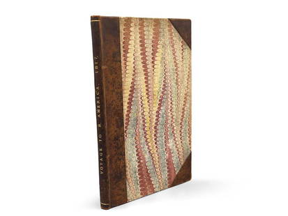
Sold2023Montule: Voyage to North America"A Voyage to North America, and the West Indies in 1817", E. Montule. First edition. London. Printed for Sir Richard Phillips and Co. 1821. 9-1/2in tall x 6in wide. | Philadelphia Metro area delivery,See Sold Price
Sold2017Woodbridge: Antique Map of North America & West IndiesWOODBRIDGE, W.C. . London: Whittaker, 1821. From "Modern Atlas". Approximately 8-1/2 x 10-1/2, in plastic sleeve. Right margin a little close trimmed (no loss of image), else fine. Depicts the North ASee Sold Price
Sold2016ANTIQUE 1908 Illustrated Hardcover Fishing BookAntique 1908 Illustrated Hardcover Fishing Book. "American Food and Game Fishes. A popular account of all the species found in America North of the Equator by David Starr Jordan & Barton Evermann. HARSee Sold Price
Sold2022History of the Indian Tribes of North America by Thomas McKenney and James Hall, Vol. I & IIHistory of the Indian Tribes of North America by Thomas McKenney and James Hall, Vol. I & II Volume I, Philadelphia: Published by Edward C. Biddle, 23 Minor Street. 1836. Volume II, Philadelphia: PublSee Sold Price
Sold20201761 MAP OF NORTH AMERICA BY ROCQUE18th century map GENERAL MAP OF NORTH AMERICA 1754-1761 by John Rocque, London by A. Drury, 2 part map, 35.5 x 36 inches, good condition.See Sold Price
Sold2016Map of North America...David H. Vance, engraved by J.H. Young. Philadelphia: Anthony Finley, 1825. Engraved map in 5 parts with original hand color in outline. 25 7/8 x 20 1/2 inches sheet, 30 5/8 x 25 1/2 inches framed.See Sold Price
Sold2022Seymour & Birch View of the City of New York in New York State, North AmericaSEYMOUR, Samuel (Active, 1797-1823), After William BIRCH (1755-1834). The City of New York in the State of New York, North America. Engraving with hand color by William H. Morgan, Philadelphia. BristaSee Sold Price
Sold2017McKenney & Hall, "Indian Tribes of North America"Thomas L. McKenney (American, 1785-1859) and James Hall (American, 1793-1868) History of the Indian Tribes of North America Philadelphia: D. Rice and A. N. Hart, 1855, octavo edition complete in threeSee Sold Price
Sold2023Zuber Views of North America Wall Paper CompleteAntique Zuber and Co. Panoramic Wallpaper "Les Vues d'Amerique du Nord" Includes Complete Wall Paper Panels. These panels were professionally removed from a New York Estate and are offered in the origSee Sold Price
Sold2023(AMERICAN INDIANS.) Thomas McKenney and James Hall. History of the Indian Tribes of North America.(AMERICAN INDIANS.) Thomas McKenney and James Hall. History of the Indian Tribes of North America. 120 hand-colored lithograph plates plus a hand-colored dedication leaf. iv, 333; xvii, 9-290; iv, 18-See Sold Price
Sold2024Map of United States of North America, 1785Map of United States of North America, 1785, The Royal Islands of Newfoundland. 26 3/4 x 32 3/4 in framed. 19 x 25 in unframed.Local Pick up call one day before to make an appointment. TO SHIP THIS ITSee Sold Price
Sold2023AUDUBON, John James and John BACHMAN. The Quadrupeds of North America. FIRST OCTAVO EDITION.AUDUBON, John James (1785-1851) and John BACHMAN (1790-1874). The Quadrupeds of North America. New York: V.G. Audubon, 1849, 1851, 1854. 3 volumes, 8vo (265 x 177 mm). Half-titles, 155 hand-colored liSee Sold Price
Sold20241719 Map of Colonial era North America, by Sanson - JaillotTitle: 1719 Map of Colonial era North America, by Sanson - Jaillot Date/Period: 1719 Materials: Copperplate engraved Size: 25 1/2 x 18” This map is a rare and valuable map of history, showing NoSee Sold Price
May 16Potter & Potter AuctionsSTORM, Mark. Official Texas Brags Map of North America. 194...$200(1 bid)
3 days LeftKellie's Estate SalesWool Hudson Bay 4 Point Blanket England Approximately 9'x 7'$120(2 bids)


![Barton. A Flora of North America.: [Botany] Barton, William P. C. A Flora of North America. Volume III. 4to. (viii), 100 pp. Original morocco in buff boards, raised bands, gilt spine designs in panels with lettering. Bennett page 9. Si](https://p1.liveauctioneers.com/179/322586/173446593_1_x.jpg?height=310&quality=70&version=1710365045)


![[1915] Quaint and Historic Forts of North America (1 of 5)](https://p1.liveauctioneers.com/5755/327684/176532954_1_x.jpg?height=282&quality=70&version=1714078974)


