Sold20191748 Bellin World Map -- Essay d'une Carte Reduite,Reserve Reduced! Title/Content of Map: 1748 Bellin World Map -- Essay d'une Carte Reduite, Contenant les Parties Connuees du Globe Terrestre Date: 1748, Paris Cartographer: J Bellin Size: 19.6 X 27.4See Sold Price
Sold2018* BELLIN, Jacques Nicholas (1703-1772). Essay d'une* BELLIN, Jacques Nicholas (1703-1772). Essay d'une Carte Reduite, Contenant les Parties Connuees du Globe Terrestre. Paris, 1748. Engraved map of the world on Mercator's projection, image 500 x 700 mSee Sold Price
Sold2023MAP, China & Korea, BellinChina & Korea. Jacques Nicolas Bellin, L'Empire de la Chine pour Servir a l'Histoire Generale des Voyages, from Histoire Generale des Voyages, 1748 (dated). Hand Color. Attractive and detailed map ofSee Sold Price
Sold2022MAP, World, BellinWorld. Jacques Nicolas Bellin, Carte Reduite des Parties Connues du Globe Terrestre Dressee au Depost des Cartes Plans et Journaux de la Marine..., 1755 (dated). Hand Color. This is the rare first ediSee Sold Price
2024Province de Quan-tong… & Royaume de Kauli ou Corée'. Korea. BELLIN 1748 mapTitle: Province de Quan-tong… & Royaume de Kauli ou Corée'. Korea. BELLIN 1748 map Description: Carte de la Province de Quan-tong ou Lyau-tong, et du Royaume de Kau-Li ou Corée [Map ofSee Sold Price
Sold2017Bellin: Antique Map of Chinese Empire, 1748Map: L'Empire de la Chine Cartographer: Bellin Place & Date: Paris / 1748/1760 Size: 15 5/8" x 11 1/4" Condition: outline color; old folds; overall age toning; a light water stain in the right marginSee Sold Price
Sold2018Bellin / la Harpe: Antique Map of the World, 1740Title/Content of Map: Rare large world Map Date Printed: 1740-1770's Cartographer: J.N. Bellin & J.F. La Harpe Material/Medium: Paper Size: 21 1/4" x 28" Copperplate engraved. From the 'Abrege de L'HiSee Sold Price
Sold2017Bellin: Map of L'Empire de la Chine, 1748L'Empire de la Chine. Bellin's superbly rendered map of the Empire of China and the Kingdom of Korea, with good topographical detail, many place names, and three elaborate cartouches, from Prevost d'ESee Sold Price
Sold2017Bellin: Antique Map of Madera & Porto Santo, 1748Map: Karte von den Eylanden Madera und Porto Santo Cartographer: Bellin Place & Date: Leipzig / 1748 Size: 8 5/8" x 6 1/8" Condition: old color; overall age toning and some staining and spotting, mostSee Sold Price
Sold2018Bellin: Antique Map of Cape Verde Islands, 1748Title/Content of Map: Karte von den Eylanden des Grunen Vorgeburges Cartographer: Bellin Place & Date: Leipzig / 1748 Size: 11" x 8 1/4" Condition: old color; overall age toning and some staining andSee Sold Price
Sold2023Four Antique Maps, China & Asia, Gerard Mercator, Jacques BellinDescription: To include a 1628 map of China and Asia by from the Gerard Mercator Atlas Minor (framed), a 1748 copper engraved Jacques Bellin map of Cathay (Northern China & Southern Mongolia), a 1749See Sold Price
Sold2019Pluche, Noel 1748 Map of The World Hemipsheres"Mappemonde" Copper Engraved Map Published 1748, The Hague for "Le Spectacle de la nature" by Noel Antoine Pluche. Folds as issued. Paper Size: 11 x 6.5 inch (28 x 16.5cm) Very minor toning on right fSee Sold Price
Sold2018Anson. A Voyage Round The World... 1748. 1st ed.[Travel] George Anson. A Voyage Round The World In The Years MDCCCXL, I, II, III, IV. Compiled… By Richard Walter... Lon: for the author by J. & P. Knapton, 1748. 1st edition. 42 plates: maps and viSee Sold Price
Sold20231748 George Anson World Voyage 3 HUGE MAPS Spain South America Sea Navigation1748 George Anson World Voyage 3 HUGE MAPS Spain South America Sea Navigation George Anson was an 18th-century British Navy admiral who is noted for his important world voyage in which he circumnavigaSee Sold Price
Sold2023ANSON. A Voyage round the World, 1748George ANSON. A Voyage round the World ... Second Edition. London:1748. Octavo. 3 folding maps (Toned, no plates, tears to maps, plates). Contemporary calf (extremities worn). Printed in the same yearSee Sold Price
Sold2022MAP, Australia, BellinA Rare Pre-Cook Map Focusing on Australia. Australia. Jacques Nicolas Bellin, Carte Reduite des Terres Australes pour Servir a l'Histoire des Voyages, from Prevost's Histoire Generale des Voyages, 175See Sold Price
Sold2023MAP, Philippines, BellinSouthern Philippines. Jacques Nicolas Bellin, Carte des Isles Philippines Dressee sur la Carte Espagnole du R.P. Murillo de Velarde. 2e. Feuille..., from Histoire Generale des Voyages, 1752 (dated). HSee Sold Price
Sold2023MAP, China, BellinChina, Korea & Japan. Jacques Nicolas Bellin, Carte des Isles du Japon et la Presqu' Isle de Coree avec les Costes de la Chine Depuis Pekin Jusqua Canton, from Prevost's Histoire Generale des Voyages�See Sold Price
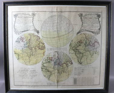
Sold20231747 Leonhard Euler Map of the World with Earth Eclipse & SolarFramed November 1747 Leonhard Euler Map of the World with earth and lunar eclipse including calculated degrees of the eclipse arriving 1748. This would be an important and timely prediction of a majorSee Sold Price
Sold2023MAP, Southern USA, BellinColonial Southern United States. Jacques Nicolas Bellin, Partie de la Coste de la Louisiane et de la Floride Depuis le Mississipi Jusqua St. Marc d'Apalache Dressee sur les Manuscrits du Depost des PlSee Sold Price
Sold2023MAP, Southeast USA, BellinColonial Southeast United States. Jacques Nicolas Bellin, Carte de la Caroline et Georgie. Pour Servir a l'Histoire Generale des Voyages, from Histoire Generale des Voyages, 1757 (dated). Hand Color.See Sold Price
Sold2021MAP, Southeast Asia, BellinSoutheast Asia. Bellin/Van Schley, Carte des Royaumes de Siam, de Tunquin, Pegu, Ava, Aracan, &c. pour Servir a l'Histoire Generale des Voyages, from Histoire Generale des Voyages, 1760 (circa). HandSee Sold Price
Sold2019MAP - Hispaniola & Bahamas. BellinNorthern Hispaniola & Southern Bahamas. Jacques Nicolas Bellin, Carte Reduite des Debouquemens de St. Domingue Dressee pour le Service des Vaisseaux du Roy..., 1768 (dated). Hand Color. This large-scaSee Sold Price
Sold2020Island Juan Fernandez 1748 J. N. BellinTitle/Content of Map: Island Juan Fernandez 1748 J. N. Bellin Cartographer:J. Nicolas. Bellin Date Printed: 1748 Material/Medium: Paper Size: Sheet Size 34 x 24 cm. Image 28 x 19 cm. Reserve: $95.00 SSee Sold Price
5 days LeftHunt and Peck Estate Services, Inc.Jacques Nicolas Bellin Map Of Western Part Of New France Or Canada$200(1 bid)
Featured5 days LeftJasper52Carte du Golfe du Mexique et des Isles de l'Amerique' Caribbean BELLIN 1754 map$200
3 days LeftJasper52Spanish New World Empire 1748, Viceroyalty of Peru, Potosi, Bolivia. Silver cob 4 reales$500
Featured5 days LeftJasper52Carte de l'Isle St. Christophe'. Saint Kitts/St Christopher. BELLIN 1760 map$130
7 hrs LeftRapid Estate Liquidators and Auction Gallery6 1980s 1990s National Geographic Magazines A$35
5 hrs LeftTrillium Antique Prints & Rare BooksPtolemy & Magini, pub. 1620 - Map of the World$50(1 bid)
May 17Royal Treasures Warehouse LLC1530s Old Map of the World as seen from the North & South Poles$100


![Anson. A Voyage Round The World... 1748. 1st ed.: [Travel] George Anson. A Voyage Round The World In The Years MDCCCXL, I, II, III, IV. Compiled… By Richard Walter... Lon: for the author by J. & P. Knapton, 1748. 1st edition. 42 plates: maps and vi](https://p1.liveauctioneers.com/179/122672/62428374_1_x.jpg?height=310&quality=70&version=1527272450)