Sold20231891 George Walker Massachusetts Atlas Plate No. 10 Map of Nantucket1891 George Walker Massachusetts Atlas Plate No. 10 Map of Nantucket, copyright 1891 G.H. Walker & Co. Boston, Mass, showing Nantucket, Nantucket Sound, Tuckernuck and Muskeget Islands. Sight 19 iSee Sold Price
Sold20161891 TRAVEL ATLAS OF MASSACHUSETTSGeorge H. Walker & Co., Boston. In leather roll case stamped "Railway Department".See Sold Price
Sold2016Nantucket, George H Walker 1891Title: Part of Massachusetts. Atlas Plate No. 10 Subject: Nantucket Maker: George H. Walker Date: 1891 Materials: Hand colored copperplate engraving Size: 27.5 x 19 inches Identifies the six principleSee Sold Price
Sold2016Martha's Vineyard, George H Walker 1891Title: Part of Massachusetts. Atlas Plate No. 11 Subject: Martha's Vineyard Maker: George H. Walker Date: 1891 Materials: Hand colored copperplate engraving Size: 27.5 x 19 inches Identifies the six pSee Sold Price
Sold2019Walker's Map of Nantucket, 1891Walker's Map of Nantucket, 1891, Massachusetts Atlas, Plate No. 10, copyright 1891, 1902, 1904, and 1907, Geo. H. Walker & Co., Boston, in shadow box frame with UF-5 plexiglass , label verso, 20"h x 2See Sold Price
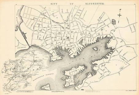
Sold2021City of Gloucester.Publication Date: c1906 Title: City of Gloucester. Cartographer: WEBBER, WINSLOW L. Height (inches): 26.75 Width (inches): 17.25 "Part of Massachusetts Atlas Copyright 1891, 1900 & 1904. Copyright 190See Sold Price
Sold2017Map of ConstantinopleThe Home Knowledge Atlas, Toronto 1891. George Cram Size: 14 x 11.5 inches No Reserve: This lot starts at $1 and has no reserve as a courtesy so that collectors can determine the true market value onSee Sold Price
Sold2017Map of New BrunswickThe Home Knowledge Atlas, Toronto 1891. George Cram Size: 22 x 13.5 inches No Reserve: This lot starts at $1 and has no reserve as a courtesy so that collectors can determine the true market value onSee Sold Price
Sold2017Map of British ColumbiaThe Home Knowledge Atlas, Toronto 1891. George Cram Size: 22 x 13.5 inches No Reserve: This lot starts at $1 and has no reserve as a courtesy so that collectors can determine the true market value onSee Sold Price
Sold2017North-West Ontario. Manitoba and North-West DisctrictsThe Home Knowledge Atlas, Toronto 1891. George Cram Size: 22 x 13.5 inches No Reserve: This lot starts at $1 and has no reserve as a courtesy so that collectors can determine the true market value onSee Sold Price
Sold2023GEORGE WALKER ATLAS MAP OF MARTHA'S VINEYARD 1891 19" x 27.5". Framed 26.5" x 38".GEORGE WALKER ATLAS MAP OF MARTHA'S VINEYARD1891Depicts Martha's Vineyard and the Elizabeth Islands.19" x 27.5". Framed 26.5" x 38".See Sold Price
Sold2016George Cram: Nova Scotia Map Plate 2, 1891Map: Nova Scotia Plate 2 Maker: George Cram Date: 1891 Size: 21.75 x 13.5 inches For "The Home Knowledge Atlas" George F. Cram (1842-1928) served in the U.S. Army during the American Civil War. AfterSee Sold Price
Sold2016George Cram: Map of Eastern Part of Quebec, 1891Map: Eastern Part of Quebec Maker: George Cram Date: 1891 Size: 13.5 x 21.75 inches For "The Home Knowledge Atlas" George F. Cram (1842-1928) served in the U.S. Army during the American Civil War. AftSee Sold Price
Sold2016Geroge Cram: Map of Western Part of Quebec, 1891Map: Western Part of Quebec Maker: George Cram Date: 1891 Size: 13.5 x 21.75 inches For "The Home Knowledge Atlas" George F. Cram (1842-1928) served in the U.S. Army during the American Civil War. AftSee Sold Price
Sold2023Vintage Bench Made Firkin Storage or Magazine BinMid 20th century. Signed by the maker at the underside George Bennett Co, Gardner, Massachusetts. The brass bound bin having a divider at the center and traditional wood handle atop three turned woodSee Sold Price
Sold20231891 F.W. BEERS ATLAS OF THE HUDSON RIVER NYC TO TROY 21" X 16 1/2" BAD COVER AND BINDING BUT THE1891 F.W. BEERS ATLAS OF THE HUDSON RIVER NYC TO TROY 21" X 16 1/2" BAD COVER AND BINDING BUT THE INTERIOR IS GOODSee Sold Price
Sold20231891 Grant's Bankers' & Brokers' Railroad AtlasNew York,1891 "Grant's, Bankers' & Brokers' Railroad Atlas" compiled and published by A.A. Grant in 1891. Print on paper,18" x 14". From the collection of a Seekonk, Massachusetts estate.See Sold Price
Sold2020Tunison's Atlas of the World 1891Title/Content of Map: Tunison's Atlas of the World 1891 Date Printed: 1891 Material/Medium: Bound Atlas Size: folio, approx 12x 14 inches Additional Info: 1st. edition. 207pp. [i/ii], folio. Brown cloSee Sold Price
Sold2017Cram: Antique Birds-Eye-View of the Holy Land, 1891Map: Birds-Eye-View of the Holy Land Date: 1891 From Cram's "Unrivaled Family Atlas of the World Indexed" Size: 14.5 x 11 inches George F. Cram (1842-1928) served in the U.S. Army during the AmericanSee Sold Price
Sold2017Cram: Antique Map of Indian Territory, 1891Map: Indian Territory Date: 1891 From Cram's "Unrivaled Family Atlas of the World Indexed" Size: 14.5 x 11 inches George F. Cram (1842-1928) served in the U.S. Army during the American Civil War. AfteSee Sold Price
Sold2017Cram: Antique Driving Map of Philadelphia, 1891Map: New Driving Map of Philadelphia Date: 1891 From Cram's "Unrivaled Family Atlas of the World Indexed" Size: 22 x 14 inches George F. Cram (1842-1928) served in the U.S. Army during the American CiSee Sold Price
Sold2017Cram: Antique Map of California, 1891Map: California Date: 1891 From Cram's "Unrivaled Family Atlas of the World Indexed" Size: 14 x 22 inches George F. Cram (1842-1928) served in the U.S. Army during the American Civil War. After the waSee Sold Price
Sold2020(6vol) HISTORY OF HAMPTON COURT PALACE"The History of Hampton Court Palace in Tudor Times... by Ernest Law, B.A... London: George Bell and Sons," 1885-1891, with many illustrations throughout, 8vo, finely bound in three-quarter red moroccSee Sold Price
Sold2021[Bindings] Boswell's Life of JohnsonBOSWELL'S LIFE OF JOHNSON… EDITED BY GEORGE BIRKBECK HILL. New York: Harper & Brothers, 1891. 6 v. 8vo. Illustrated. Bound in period navy 1/2 morocco by Estes & Lauriat, with red flower onlays to spSee Sold Price
Jul 06Case Antiques, Inc. Auctions & AppraisalsColton's Atlas of the World, 1856, in Two Volumes; plus Africa / Mahdist War Map$500(1 bid)
2 days LeftFreeman's | Hindman[Americana] Hancock, John: Partially-Printed Document, signed$950(4 bids)
Jul 11Eldred'sGEORGE MACHON (Massachusetts, Contemporary), "Cold Storage Beach", Sesuit Harbor, East Dennis,$150
Jul 11Eldred'sGEORGE MACHON (Massachusetts, Contemporary), "Striped Bass", Cape Cod Bay., Oil on panel, 7" x 16".$125
Jul 11Eldred'sMOUNTED HALF HULL MODEL OF A SCHOONER BY GEORGE MACHON Massachusetts, Contemporary Oval mahogany$150
Jul 11Eldred'sGEORGE MACHON (Massachusetts, Contemporary), "Lobster Boat"., Oil on board, 8" x 10". Framed.$150
5 days LeftSwann Auction Galleries(LAW.) Group of 4 folio printings of early laws from Massachusetts, New Hampshire, New Jersey, and$750
BonhamsCased Fire Alarm with Eight-inch Bell, United States Fire & Police Telegraph Co., Boston, Massac...$3,200
Jul 11Eldred'sGEORGE ELMER BROWNE (Massachusetts/Connecticut, 1871-1946), "The Trawlers"., Etching on paper, 8.25"$100
2 days LeftFreeman's | Hindman[Presidential] Roosevelt, Theodore: Partially-Printed Document, signed$225(2 bids)
3 days LeftUniversity ArchivesContinuation of the History of the Province of Massachusetts Bay, 1748$100
BonhamsLock of George Washington's Hair and Related Correspondence between the Derbys of Salem, Massach...$1,800(28 bids)


![Tunison's Atlas of the World 1891: Title/Content of Map: Tunison's Atlas of the World 1891 Date Printed: 1891 Material/Medium: Bound Atlas Size: folio, approx 12x 14 inches Additional Info: 1st. edition. 207pp. [i/ii], folio. Brown clo](https://p1.liveauctioneers.com/5584/187575/94368494_1_x.jpg?height=310&quality=70&version=1607465981)


![[Bindings] Boswell's Life of Johnson: BOSWELL'S LIFE OF JOHNSON… EDITED BY GEORGE BIRKBECK HILL. New York: Harper & Brothers, 1891. 6 v. 8vo. Illustrated. Bound in period navy 1/2 morocco by Estes & Lauriat, with red flower onlays to sp](https://p1.liveauctioneers.com/3532/206619/104976694_1_x.jpg?height=310&quality=70&version=1622852586)


![[Americana] Hancock, John: Partially-Printed Document, signed (1 of 2)](https://p1.liveauctioneers.com/65/332523/179335010_1_x.jpg?height=282&quality=70&version=1717622830)


![[Presidential] Roosevelt, Theodore: Partially-Printed Document, signed (1 of 2)](https://p1.liveauctioneers.com/65/332523/179335230_1_x.jpg?height=282&quality=70&version=1717709445)


