Sold2017Bradford: Antique Map of New Hemisphere, 1838Title/Content of Map: New Hemisphere by Bradford Date Printed: 1838/1841 Cartographer: Thomas G. Bradford Material/Medium: Paper Size: 13" x 16 1/2" A General Atlas of the World with a seperate Map ofSee Sold Price
Sold2017Bradford: Antique Map of New Hampshire, 1838Title/Content of Map: New Hampshire by Bradford Date Printed: 1838/1841 Cartographer: Thomas G. Bradford Material/Medium: Paper Size: 13" x 16 1/2" Hand colored. A General Atlas of the World with a SeSee Sold Price
Sold2017Bradford: Antique Map of New Jersey, 1838Title/Content of Map: New Jersey by Bradford Date Printed: 1838/1841 Cartographer: Thomas G. Bradford Material/Medium: Paper Size: 13" x 16 1/2" Condition: Excellent Hand colored. A General Atlas of tSee Sold Price
Sold2018Bradford: Antique Map of Iowa and Wisconsin, 1838Title/Content of Map: 1838 Bradford Map of Iowa and Wisconsin -- Iowa and Wisconsin Date Printed: 1838, New York Cartographer: T Bradford Size: 14.3 x 11.5 in. This is a rather scarce early map of porSee Sold Price
Sold2017Bradford: Antique Map of Lower Canada, 1838Title/Content of Map: Lower Canada and New Brunswick Date Printed: 1838/1841 Cartographer: Thomas G. Bradford Material/Medium: Paper Size: 16 1/2" x 13 1/2" Hand colored. A General Atlas of the WorldSee Sold Price
Sold2017Bradford: Antique Map of Four US Cities, 1838Title/Content of Map: Cities of Washington D.C., New Orleans, Cincinnati and Louisville Date Printed: 1838/1841 Cartographer: Thomas G. Bradford Material/Medium: Paper Size: 13" x 16 1/2" Hand coloredSee Sold Price
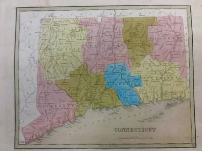
Sold2018Bradford: Antique Map of Connecticut, 1838Title/Content of Map: Connecticut by Bradford Date Printed: 1838 Cartographer: Thomas G. Bradford Size: 14" x17" Material/Medium: Paper Provenance: New York A General Atlas of the World with a separatSee Sold Price
Sold2017Bradford: Antique Map of New Hampshire & Vermont, 1835Title/Content of Map: New Hampshire & Vermont Date Printed: 1835 Cartographer: T. G. Bradford Material/Medium: Paper Size: 9 1/2" x 13" A Comprehensive Atlas Geographical, Historical & Commercial. PubSee Sold Price
Sold2017Bradford: Antique Map of Louisiana, 1838Title/Content of Map: Louisiana by Bradford Date Printed: 1838/1841 Cartographer: Thomas G. Bradford Material/Medium: Paper Size: 16 1/2" x 13" Hand colored. A General Atlas of the World with a SeparaSee Sold Price
Sold2017Bradford: Antique Map of Ohio, 1838Title/Content of Map: Ohio by Bradford Date Printed: 1838/1841 Cartographer: Thomas G. Bradford Material/Medium: Paper Size: 13" x 16 1/2" Hand colored. A General Atlas of the World with a Separate MaSee Sold Price
Sold2017Bradford: Antique Map of Philadelphia, 1838Title/Content of Map: Philadelphia b Bradford Date Printed: 1838/41 Cartographer: Thomas G. Bradford Material/Medium: Paper Size: 13" x 16 3/4" Condition: Excellent Hand colored. A General Atlas of thSee Sold Price
Sold2017Bradford: Antique Map of Maine, 1838Title/Content of Map: Maine by Bradford Date Printed: 1838/1841 Cartographer: Thomas G. Bradford Material/Medium: Paper Size: 13" x 16 1/2" Hand colored. A General Atlas of the World with a Separate MSee Sold Price
Sold2017Bradford: Antique Map of Tennessee, 1838Title/Content of Map: Tennessee by Bradford Date Printed: 1838/1841 Cartographer: Thomas G. Bradford Material/Medium: Paper Size: 13" x 16 1/2" Hand colored. A General Atlas of the World with a SeparaSee Sold Price
Sold2017Bradford: Antique Map of Philadelphia, 1838Title/Content of Map: Philadelphia by Bradford Date Printed: 1838/1841 Cartographer: Thomas G. Bradford Material/Medium: Paper Size: 16 3/4" x 13" Hand colored. A General Atlas of the World with a sepSee Sold Price
Sold2017Bradford: Antique Map of Kentucky, 1838Title/Content of Map: Kentucky by Bradford Date Printed: 1838/1841 Cartographer: Thomas G. Bradford Material/Medium: Paper Size: 16 1/2" x 13" Hand colored. A General Atlas of the World with a SeparatSee Sold Price
Sold2017Bradford: Antique Map of Arkansas, 1838Title/Content of Map: Arkansas by Bradford Date Printed: 1838/1841 Cartographer: Thomas G. Bradford Material/Medium: Paper Size: 13" x 16 1/2" Hand colored. A General Atlas of the World with a SeparatSee Sold Price
Sold2017Bradford: Antique Map of Illinois, 1838Title/Content of Map: Illinois by Bradford Date Printed: 1838/1841 Cartographer: Thomas G. Bradford Material/Medium: Paper Size: 13" x 16 1/2" Hand colored. A General Atlas of the World with a SeparatSee Sold Price
Sold2017Bradford: Antique Map of Alabama, 1838Title/Content of Map: Alabama by Bradford Date Printed: 1838/1841 Cartographer: Thomas G. Bradford Material/Medium: Paper Size: 13" x 16 1/2" Hand colored. A General Atlas of the World with a SeparateSee Sold Price
Sold2017Bradford: Antique Map of Pennsylvania, 1838Title/Content of Map: Pennsylvania by Bradford Date Printed: 1838/1841 Cartographer: Thomas G. Bradford Material/Medium: Paper Size: 16 1/2" x 13" Hand colored. A General Atlas of the World with a SepSee Sold Price
Sold2017Bradford: Antique Map of Indiana, 1838Title/Content of Map: Indiana by Bradford Date Printed: 1838/1841 Cartographer: Thomas G. Bradford Material/Medium: Paper Size: 13" x 16 1/2" Hand colored. A General Atlas of the World with a SeparateSee Sold Price
Sold2017Bradford: Antique Map of Massachusets, 1838Title/Content of Map: Massachusets by Bradford Date Printed: 1838/1841 Cartographer: Thomas G. Bradford Material/Medium: Paper Size: 13" x 16 1/2" Hand colored. A General Atlas of the World with a SepSee Sold Price
2017Bradford: Antique Map of Conneticut, 1838Title/Content of Map: Conneticut by Bradford Date Printed: 1838/1841 Cartographer: Thomas G. Bradford Material/Medium: Paper Size: 13" x 16 1/2" Hand colored. A General Atlas of the World with a SeparSee Sold Price
Sold2017Bradford: Antique Map of Pennsylvania & New Jersey 1835Title/Content of Map: Pennsylvania & New Jersey Date Printed: 1835 Cartographer: T.G. Bradford Material/Medium: Paper Size: 13" x 10" Condition: Excellent Hand colored outlines. Published in PhiladelpSee Sold Price
Sold2017Bradford: Antique Map of Vermont, 1838Title/Content of Map: Vermont by Bradford Date Printed: 1838/1841 Cartographer: Thomas G. Bradford Material/Medium: Paper Size: 13" x 15" A General Atlas of the World with a seperate Map of each of thSee Sold Price
4 days LeftJasper521761 NEW DICTIONARY OF TRADE & COMMERCE R. ROLT antique FOLIO ILLUSTRATED w/MAPS$440
9 hrs LeftTrillium Antique Prints & Rare BooksMitchell's A New Universal Atlas.. - Volume with 73 Maps$1,000(1 bid)
9 hrs LeftTrillium Antique Prints & Rare BooksCarey, pub. 1814 - Map of the East Indies with India, China, & New Holland (Australia)$50(1 bid)
9 hrs LeftTrillium Antique Prints & Rare BooksCarey, pub. 1814 - Map of New South Wales, Australia$50
May 11Trillium Antique Prints & Rare BooksPrevost - Map of the South Pacific Ocean with New Holland (Australia), New Zealand, and part of the$50
5 days LeftJasper52Bahamas. Turks & Caicos. New Providence. Nassau plan. 53x67cm. STANFORD 1896 map$360
5 days LeftJasper52Jamaica & the Pedro Bank. South Cuba Haiti. ADMIRALTY sea chart 1866 (1968) map$120
5 days LeftJasper52Venezuela Coast Trinidad Tobago Isla Margarita ADMIRALTY chart 1894 (1950) map$120
Featured5 days LeftJasper52Barbuda Island. West Indies Caribbean. ADMIRALTY sea chart 1850 (1966) old map$120
5 days LeftJasper52General Map of the West Indies'. West sheet only. Bryan EDWARDS. Caribbean 1794$700
5 days LeftJasper52West India Islands & Caribbean Sea Sheet 2 ADMIRALTY sea chart 1913 (1949) map$120
5 days LeftJasper52BRITISH WEST INDIES. Jamaica Antilles Virgin Cayman Islands. SDUK 1844 old map$150
5 days LeftJasper52BRITISH WEST INDIES Jamaica Trindad Antilles Virgin Cayman Islands SDUK 1844 map$150