Sold2017Bradford: Antique Map of Philadelphia, 1838Title/Content of Map: Philadelphia b Bradford Date Printed: 1838/41 Cartographer: Thomas G. Bradford Material/Medium: Paper Size: 13" x 16 3/4" Condition: Excellent Hand colored. A General Atlas of thSee Sold Price
Sold2017Bradford: Antique Map of Philadelphia, 1838Title/Content of Map: Philadelphia by Bradford Date Printed: 1838/1841 Cartographer: Thomas G. Bradford Material/Medium: Paper Size: 16 3/4" x 13" Hand colored. A General Atlas of the World with a sepSee Sold Price
Sold20211838 Bradford Map of Indiana -- IndianaTitle: 1838 Bradford Map of Indiana -- Indiana Cartographer: T Bradford Year / Place: 1838 Boston Map Dimension (in.): 14.2 x 11 in. This is a nice and highly detailed state map. The counties are coloSee Sold Price
Sold2016(4) 1838 BRADFORD Maps: NC, SC, GA, FL.[United States/South] 4 Maps. ++ NORTH CAROLINA. ++ SOUTH CAROLINA. ++ GEORGIA. ++ FLORIDA. ++ +Maps 28, 30, 31, 32 from T. G. Bradford, “An Illustrated Atlas, Geographical, Statistical, And HistoriSee Sold Price
Sold2016(4) 1838 BRADFORD Maps: OH, IN, MI, TN[United States/Near West] 4 Maps. ++ OHIO. ++ INDIANA. ++ MICHIGAN. [With inset of upper peninsula.] ++ TENNESSEE. ++ Maps 19, 20, 22, 29 from T. G. Bradford, “An Illustrated Atlas, Geographical, StSee Sold Price
Sold20164 Maps: Bradford (1838): Mass., CT, NJ, Boston.[United States/Northeast] 4 Maps. ++ MASSACHUSETTS. ++ BOSTON. ++ CONNECTICUT. ++ NEW JERSEY. ++ Maps 10, 11, 13, and 16 from T. G. Bradford, “An Illustrated Atlas, Geographical, Statistical, And HiSee Sold Price
Sold2018Bradford: Antique Map of Iowa and Wisconsin, 1838Title/Content of Map: 1838 Bradford Map of Iowa and Wisconsin -- Iowa and Wisconsin Date Printed: 1838, New York Cartographer: T Bradford Size: 14.3 x 11.5 in. This is a rather scarce early map of porSee Sold Price
Sold20174 TN Maps, Bradford, 1835, 1838, & 18411st item: "Tennessee" Map, by Thomas G. Bradford, engraved by George W. Boynton, published by William D. Ticknor, Boston, 1835. From "A Comprehensive Atlas, Geographical, Historical & Commercial" by TSee Sold Price
Sold2017Bradford: Antique Map of Louisiana, 1838Title/Content of Map: Louisiana by Bradford Date Printed: 1838/1841 Cartographer: Thomas G. Bradford Material/Medium: Paper Size: 16 1/2" x 13" Hand colored. A General Atlas of the World with a SeparaSee Sold Price
Sold2017Bradford: Antique Map of Ohio, 1838Title/Content of Map: Ohio by Bradford Date Printed: 1838/1841 Cartographer: Thomas G. Bradford Material/Medium: Paper Size: 13" x 16 1/2" Hand colored. A General Atlas of the World with a Separate MaSee Sold Price
Sold2017Bradford: Antique Map of Maine, 1838Title/Content of Map: Maine by Bradford Date Printed: 1838/1841 Cartographer: Thomas G. Bradford Material/Medium: Paper Size: 13" x 16 1/2" Hand colored. A General Atlas of the World with a Separate MSee Sold Price
Sold2017Bradford: Antique Map of Tennessee, 1838Title/Content of Map: Tennessee by Bradford Date Printed: 1838/1841 Cartographer: Thomas G. Bradford Material/Medium: Paper Size: 13" x 16 1/2" Hand colored. A General Atlas of the World with a SeparaSee Sold Price
Sold2017Bradford: Antique Map of Kentucky, 1838Title/Content of Map: Kentucky by Bradford Date Printed: 1838/1841 Cartographer: Thomas G. Bradford Material/Medium: Paper Size: 16 1/2" x 13" Hand colored. A General Atlas of the World with a SeparatSee Sold Price
Sold2017Bradford: Antique Map of Arkansas, 1838Title/Content of Map: Arkansas by Bradford Date Printed: 1838/1841 Cartographer: Thomas G. Bradford Material/Medium: Paper Size: 13" x 16 1/2" Hand colored. A General Atlas of the World with a SeparatSee Sold Price
Sold2017Bradford: Antique Map of Illinois, 1838Title/Content of Map: Illinois by Bradford Date Printed: 1838/1841 Cartographer: Thomas G. Bradford Material/Medium: Paper Size: 13" x 16 1/2" Hand colored. A General Atlas of the World with a SeparatSee Sold Price
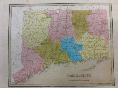
Sold2018Bradford: Antique Map of Connecticut, 1838Title/Content of Map: Connecticut by Bradford Date Printed: 1838 Cartographer: Thomas G. Bradford Size: 14" x17" Material/Medium: Paper Provenance: New York A General Atlas of the World with a separatSee Sold Price
Sold2017Bradford: Antique Map of Alabama, 1838Title/Content of Map: Alabama by Bradford Date Printed: 1838/1841 Cartographer: Thomas G. Bradford Material/Medium: Paper Size: 13" x 16 1/2" Hand colored. A General Atlas of the World with a SeparateSee Sold Price
Sold2017Bradford: Antique Map of Pennsylvania, 1838Title/Content of Map: Pennsylvania by Bradford Date Printed: 1838/1841 Cartographer: Thomas G. Bradford Material/Medium: Paper Size: 16 1/2" x 13" Hand colored. A General Atlas of the World with a SepSee Sold Price
Sold2017Bradford: Antique Map of Indiana, 1838Title/Content of Map: Indiana by Bradford Date Printed: 1838/1841 Cartographer: Thomas G. Bradford Material/Medium: Paper Size: 13" x 16 1/2" Hand colored. A General Atlas of the World with a SeparateSee Sold Price
Sold2017Bradford: Antique Map of Massachusets, 1838Title/Content of Map: Massachusets by Bradford Date Printed: 1838/1841 Cartographer: Thomas G. Bradford Material/Medium: Paper Size: 13" x 16 1/2" Hand colored. A General Atlas of the World with a SepSee Sold Price
2017Bradford: Antique Map of Conneticut, 1838Title/Content of Map: Conneticut by Bradford Date Printed: 1838/1841 Cartographer: Thomas G. Bradford Material/Medium: Paper Size: 13" x 16 1/2" Hand colored. A General Atlas of the World with a SeparSee Sold Price
Sold2017Bradford: Antique Map of Vermont, 1838Title/Content of Map: Vermont by Bradford Date Printed: 1838/1841 Cartographer: Thomas G. Bradford Material/Medium: Paper Size: 13" x 15" A General Atlas of the World with a seperate Map of each of thSee Sold Price
Sold2017Bradford: Antique Map of Iowa & Wisconsin, 1838Title/Content of Map: Rare and Important early Iowa and Wisconsin Date Printed: 1838/1841 Cartographer: Thomas G. Bradford Material/Medium: Paper Size: 13" x 16 1/2" Hand colored. A General Atlas of tSee Sold Price
Sold2017T.G Bradford: Antique Map of United States, 1838Title: Map of United States by T.G Bradford Date: 1838 Medium: Wax Engraving Dimensions (in): 25 x 16 Condition: Excellent Condition Thomas G. Bradford was the author of the Illustrated Atlas of the USee Sold Price
7 days LeftTrillium Antique Prints & Rare BooksWilkes - 6 View Engravings of New Zealand, Tonga, Fiji, &c.$100
7 days LeftTrillium Antique Prints & Rare BooksWilkes - 13 Native People Engravings (Portrait of Commanders including Wilkes, people from New$100
Jun 08Brzostek’s Auction Service, Inc.Antique Seneca-Cayuga Wall map 1859 by Arz Dawson, Philadelphia$10
Jun 08Brzostek’s Auction Service, Inc.Antique Seneca-Cayuga Wall map 1859 by Arz Dawson, Philadelphia$10
Jun 12Dan Morphy AuctionsPHELPS’S TRAVELERS GUIDE THROUGH THE UNITED STATES; CONTAINING UPWARDS OF SEVEN HUNDRED$1,000
Jun 14DuMouchellesWilliam H. Gamble (American, B. 1863) Hand Colored Engraving, Ca. 1863, "County Map of Michigan And$50(1 bid)
Jun 08Early American History Auctions1776 Map, PARTIE ORIENTALE DU CANADA, AVEC LA NOUVELLE ANGLETERRE, L'ACADIE... by P. Santini, Framed$950
Jun 08Simpson Galleries, LLC.J.H. Young (1792-1870) AN AMERICAN FEDERAL PERIOD MAP, "Mitchell's Travellers Guide Through the$500
7 days LeftTrillium Antique Prints & Rare BooksDobson - Map of the World with Chart of Torrid Zone or Tropical Regions of the World$50


![(4) 1838 BRADFORD Maps: NC, SC, GA, FL.: [United States/South] 4 Maps. ++ NORTH CAROLINA. ++ SOUTH CAROLINA. ++ GEORGIA. ++ FLORIDA. ++ +Maps 28, 30, 31, 32 from T. G. Bradford, “An Illustrated Atlas, Geographical, Statistical, And Histori](https://p1.liveauctioneers.com/179/85723/44107998_1_x.jpg?height=310&quality=70&version=1457209205)
![(4) 1838 BRADFORD Maps: OH, IN, MI, TN: [United States/Near West] 4 Maps. ++ OHIO. ++ INDIANA. ++ MICHIGAN. [With inset of upper peninsula.] ++ TENNESSEE. ++ Maps 19, 20, 22, 29 from T. G. Bradford, “An Illustrated Atlas, Geographical, St](https://p1.liveauctioneers.com/179/85723/44107994_1_x.jpg?height=310&quality=70&version=1457208874)
![4 Maps: Bradford (1838): Mass., CT, NJ, Boston.: [United States/Northeast] 4 Maps. ++ MASSACHUSETTS. ++ BOSTON. ++ CONNECTICUT. ++ NEW JERSEY. ++ Maps 10, 11, 13, and 16 from T. G. Bradford, “An Illustrated Atlas, Geographical, Statistical, And Hi](https://p1.liveauctioneers.com/179/85723/44107996_1_x.jpg?height=310&quality=70&version=1457209040)