Sold2018Antique Hand Colored Maps of Westchester County NYAntique Hand Colored Maps of Westchester County NY. This lot includes three 19th century hand colored maps from the "Atlas of Westchester County, NY" by G.W. Bromley & Co. Includes one map of the VillSee Sold Price
Sold2018Antique Hand Colored Maps of Westchester County NYAntique Hand Colored Maps of Westchester County NY. This lot includes four 19th century hand colored maps from the "Atlas of Westchester County, NY" by G.W. Bromley & Co. Includes one map of PeekskillSee Sold Price
Sold2018Antique Hand Colored Maps of Westchester County NYAntique Hand Colored Maps of Westchester County NY. This lot includes three 19th century hand colored maps from the "Atlas of Westchester County, NY" by G.W. Bromley & Co. Includes one map of Pelham,See Sold Price
Sold2018Antique Hand Colored Maps of Westchester County NYAntique Hand Colored Maps of Westchester County NY. This lot includes three 19th century hand colored maps from the "Atlas of Westchester County NY" by G.W. Bromley and Co. Includes one map of HastingSee Sold Price
Sold2023Street Maps of Manhattan10 Street Maps of Manhattan, G.W. Bromley & Co. 1902 PhiladelphiaEach 22.5" H x 32.5" WProperty from the estate of Seymour Stein (1942 - 2023).See Sold Price
Sold2022(NEW YORK CITY.) G. W. Bromley & Co. Atlas of the City of New York - Borough of Manhattan. Volumes 2(NEW YORK CITY.) G. W. Bromley & Co. Atlas of the City of New York - Borough of Manhattan. Volumes 2 and 3. Volume 2, 14th Street to 59th Street: Index map and 45 hand-colored double-page lithographedSee Sold Price
Sold2018Antique Hand Colored Maps of Westchester County NYAntique Hand Colored Maps of Westchester County NY. This lot includes four 19th century hand colored maps from the "Atlas of Westchester County, NY" by G.W. Bromley & Co and Houghton Associates Inc. ISee Sold Price
Sold2020Atlas of the City of Philadelphia, Vol 2, 1886Atlas of the City of Philadelphia, Volume 2 of the 11th, 12th, 13th, 14th and 15th Wards, 1886, G. W. Bromley & Co. Is in very good condition with some small damage to the corners and at the edges andSee Sold Price
Sold2020Atlas of the City of Boston 1895Atlas of the City of Boston, City Proper and Roxbury, 1895, G.W. Bromley & Co. Has some damage to the spine and the front and back covers are coming loose but is in otherwise very good condition. MeasSee Sold Price
Sold2022Three Maps, Isle of Wight, East Indies, RussianComprising, Colton's East Indies, published by G.W., C.B. Colton & Co., Jeremiah Greenleaf's map of the Russian Empire, and J. Watt's map of Isle of Wight. Overall: 22-1/4"h x 25-1/2"w, 19"h x 21-3/4"See Sold Price
Sold2017Colton MAP OF THE STATE OF MISSISSIPPI 1867 EngravedDetails: COLTON, George W. (1827-1901) & Charles B. (1832-1916). Colton's Map of the State of Mississippi. New York: G.W. & C.B. Colton & Co., 1867. Engraved folding pocket map, full contemporary hanSee Sold Price
Sold2018Colton's MaineTitle: Colton's Maine Publication Date: 1872 Cartographer: COLTON, G.W. & C.B. Publisher: G.W. & C.B. COLTON & CO. Size: 14X11 Scarce Pocket Map of Maine. Map detailing counties, many towns, townshipsSee Sold Price
Sold2021Bacon's Map of Manchester Corrected to the PresentPublication Date: c1910 Title: Bacon's Map of Manchester Corrected to the Present Time... Cartographer: Bacon, G.W. & Co.G.W. Bacon & Co. Height: 14.2 Width: 21.75 Highly detailed city plan folding inSee Sold Price
Sold2019Road-Map of England And WalesTitle: Road-Map of England And Wales Publication Date: 1835-03-25 Cartographer: BACON, G. W. & CO. Publisher: G.W. BACON & CO. Dimension: 33Height - 26.5Width Retailed by Forster Groom & Co. Ltd. DissSee Sold Price
Sold2017Map LotLot (2) maps including Ireland (G.W. Bacon & Co. sight 8 1/2" x 12"), and "BAVARIA-HESSE/US ZONE/WURTEMBERG BADEN" (sight 23" x 20").See Sold Price
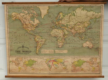
Sold2015Bacon's Excelsior Map of The WorldOn Mercator's Projection, printed in London by G. W. Bacon & Co., Ltd., circa 1880. Chromolithograph laid on canvas with both original wood hangers. 39 1/2" x 30".See Sold Price
Sold2022Slatter & Rose's Motoring and Cycling Road Map. OxfordTitle: Slatter & Rose's Motoring and Cycling Road Map. Oxford District. Cartographer: Bartholomew, John & Co. Publisher: G.W. Bacon & Co., LTD. Height: 24 Width: 34 Extremely early road map intended fSee Sold Price
Sold2018Colton's Map of the United States of AmericaReserve Reduced! Title/Content of Map: Colton's Map of the United States of America Date: 1876 Cartographer: COLTON, G.W & C.B. Publisher: G.W. & C.B. COLTON & CO. Size: 14.5 x 26 inches Double folioSee Sold Price
Sold2023PROPOSED RICHMOND AND LOUISVILLE RAILROAD MAPPROPOSED RICHMOND AND LOUISVILLE RAILROAD MAP,laid to linen,engraved, printed, and manufactured by "G.W. & C.B. COLTON & CO. / No. 182 William St. New York".1882.55" L (rolled). Provenance: From the eSee Sold Price
Sold2021Colton's Road Map of the Counties of Orange andPublication Date: 1896 Title: Colton's Road Map of the Counties of Orange and Rockland Cartographer: G.W. & C.B. Colton & Co. Publisher: G.W. & C.B. Colton & Co. Height: 22.75 Width: 26.25 State of NeSee Sold Price
Sold2017Vintage Framed Map of New JerseyFramed detailed map of the state of New Jersey. "Entered according to Act of Congress in the year 1868, by G.W. & C.B. Colton & Co. in the Clerks Office of the District Court of The United States forSee Sold Price
Sold2020G.W. BROMLEY WESTCHESTER COUNTY ATLAS 1881Hand-colored maps. As published. Dimensions: H 18.25" x W 15" Condition: Some slight age toning to pages. Binding with wear.See Sold Price
Sold20202 antique framed Southern maps2 antique framed maps: Map of South Carolina in German dated 1845. Map of Savannah and Charleston published by G.W and C.B Colton & Co and dated 1855. Overall size measures 25 1/2"h x 28"w and the papSee Sold Price
May 19Fontaine's Auction GalleryLimoges Art Nouveau Figural Porcelain Charger, W.G. & Co., France$225
2 days LeftConestoga Auction Company Division of Hess Auction GroupG.H.W. Bates and Co. "The Improved Mandolina".$50(1 bid)
7 days LeftJasper521896 Cram Map of Virginia, West Virginia, Maryland and Delaware -- Railroad and County Map of$40
4 hrs LeftFreeman's | HindmanG.W. Simons & Bro. Retailed Collins Model 1850 Foot Officer's Sword Presented to Capt. Joseph$1,500
8 hrs LeftBonhamsJohn George Brown (1831-1913) Serenity 30 x 20 in. (76.2 x 50.8 cm.) (Painted circa 1890.)$12,000
8 hrs LeftBonhamsJohn George Brown (1831-1913) Shoeshine Boy 24 1/8 x 16 1/4 in. (61.3 x 41.3 cm.) (Painted circa...$12,000