Sold2020CAREY, MATHEW. Vermont.CAREY, MATHEW. Vermont. Double-page map of Vermont engraved by Amos Doolittle. 21¾x17 inches sheet size, wide margins; original hand-color in outline; small tears in the area of center fold reinfSee Sold Price
Sold2024Ohio copy of Mathew Carey’s 1796 GENERAL ATLASCarey, Mathew (publisher). CAREY’S GENERAL ATLAS. Philadelphia: Printed by Mathew Carey, May 1, 1796. FOLIO (14.75 x 9.5 inches), COMPLETE AS PUBLISHED (including a Rare Map of The United States bySee Sold Price
Sold2017Carey: Antique Map of the West Indies, 1814Map: West Indies Publication Date: 1814 Authors: Mathew Carey, Mathew Carey Publisher: Mathew Carey Size: Double Quarto – 9.5 H x 15.5 W Inches Please note that this lot has a confidential reserve.See Sold Price
Sold2018Delaware.Title/Content of Map: Delaware. Date: 1814 Cartographer: CAREY, MATHEW/A. DOOLITTLE Size: 7.75X5.75 From the 4th edition of Carey's American Pocket Atlas. With text. Browned. Please note that this lotSee Sold Price
Sold20231816 OLIVE BRANCH Faults On Both Sides Federal And Democratic antique AMERICANAThe Olive Branch: Or Faults On Both Sides, Federal And Democratic. A Serious Appeal On The Necessity Of Mutual Foregiveness & Harmony By Carey, Mathew Middlebury, VT; 1816 The book appeared during a "See Sold Price
Sold2019United StatesTitle: United States Publication Date: c1805 Cartographer: CAREY, MATHEW ? Publisher: Size: 6.1Height - 7.1Width Anonymous pocket map, possibly from Carey's American Pocket atlas of 1805. Foxed and brSee Sold Price
Sold2019Map of the Caracas.Reserve Reduced! Title: Map of the Caracas. Publication Date: 1814 Cartographer: CAREY, MATHEW/WARNICKE, sc. Publisher: M. CAREY Size: 12.25 x 20.3 Original outline coloring. Northeast South America.See Sold Price
Sold2019SwitzerlandTitle: Switzerland Date: 1814 Cartographer: CAREY, MATHEW Publisher: M. CAREY Size: 13.1Height - 14Width Provenance: according to the best authorities. Wide margins. Browned. Foxed and spotted. Ink stSee Sold Price
Sold2023Rare map of Upper Territories by Mathew Carey, 1814Early and rare map of the old Northwest Territory. In this map the area of Michigan has yet to be understood. The extents of Saginaw Bay and Green Bay are also more or less guessed at. The map reflectSee Sold Price
Sold2016MATHEW CAREY (AMERICAN, 1760-1839) MAP OF DELAWAREMATHEW CAREY (AMERICAN, 1760-1839) MAP OF DELAWARE, hand-colored engraving on paper, titled "Delaware from the best Authorities", engraved by William Barker, published Philadelphia, 1795. Modern frameSee Sold Price
Sold2022Very scarce 1814 Map of Virginia, Mathew CareyMathew Carey's map of Virginia, one of the best large format maps of the state to appear in a Commercial Atlas. From an extremely scarce 1816 edition of Carey’s General Atlas (the same map as inSee Sold Price
Sold2023Mathew Carey, State of Pennsylvania, EngravingMathew Carey, State of Pennsylvania, Engraving. Date: 1795Framed in good vintage condition, with signs of yellowing and marks due to age. First atlas of America printed in America. First edition. ThesSee Sold Price
Sold2022Scarce 1816 map of Ireland from Mathew Carey atlasLovely and scarce map of Ireland from the very scarce 1816 edition of Mathew Carey’s General Atlas. Clearly delineates the four provinces of the country. Table in upper left identifies countiesSee Sold Price
Sold20231801 Mathew Carey (1760-1839) Antique BibleContinental, 19th century. A large bible dating to 1801. Well intact for sage, though there is loss and wear throughout. It was the first Roman Catholic version and only the second English-language trSee Sold Price
Sold2016Map. Mathew Carey: The Province of Maine.Mathew Carey: The Province of Maine From the Best Authorities By Samuel Lewis 1794. 10 1/4 x 15"See Sold Price
Sold20231797 Philadelphia Harmony Christian Hymn Book - Mathew CareyDESCRIPTION: Philadelphia Harmony, or, A Collection of Psalm Tunes, Hymns, and Anthems, Selected by A. Adgate: Together With The Rudiments of Music on a New and Improved Plan. By Anthony Adgate and prSee Sold Price
Sold20241816 Map of Brazil From Mathew Carey AtlasShows the territory of Brazil from the mouth of the Amazon to the Rio de la PlataSee Sold Price
Sold20231795 Map of South American by Mathew Carey, Philadelphia16.5 x 21.5 inches, sight. Framed, 21.5 x 27 inches. Condition reports are not available for the items in this catalog. These are antique and vintage items, and will show signs of use and wear. We havSee Sold Price
Sold2022MAPS IN BOOK, Atlases, CareyCarey's Famous 1814 General Atlas. Atlases. Mathew Carey, Carey's General Atlas, Improved and Enlarged: Being a Collection of Maps of the World and Quarters, Their Principal Empires, Kingdoms, &c., 18See Sold Price
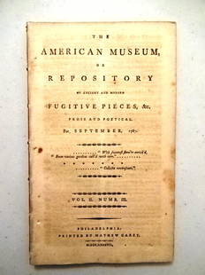
Sold20211787 Magazine First Printing of ConstitutionThe American Museum or Repository of Ancient and Modern Fugitive Pieces & c Prose and Poetical For September 1787. Published at Philadelphia by Mathew Carey MDCCLXXXVII. Vol. II Number III. COMPLETE iSee Sold Price
Sold20211787 Magazines Federalist Papers ConstitutionThe November and December 1787 issue of "The American Museum or Repositoryof Ancient and Modern Fugitive Pieces…..", Volume II Numbers V and VI, printed at Philadelphia by Mathew Carey, MDCCLXXXVII.See Sold Price
Sold2016Thos. Jefferson: Notes on the State of VAJEFFERSON, Thomas. Notes on the State of Virginia. Philadelphia: Mathew Carey, 1794. 4 3/4" H X 8 1/4" W (Octavo). 336 Pages. Second Edition (THE FIRST AUTHORIZED EDITION) of Jefferson's only full-lenSee Sold Price
Sold2021State of TN Map, M. Carey, 1814THE STATE OF TENNESSEE map, published by Mathew Carey in Carey's General Atlas, Improved and Enlarged, Philadelphia, 1814. Copperplate engraving with hand coloring depicting the state of Tennessee witSee Sold Price
Sold2023First state of an important map of the Trans-Mississippi WestMathew Carey's map, Missouri Territory formerly Louisiana, is one of the seminal maps of the period and the first atlas map to provide the cartographic detail derived from the return of the Lewis & ClSee Sold Price
May 30Cottone AuctionsEmile A. Gruppe (American, 1896-1978) "Bend in the River, Vermont"$1,000(1 bid)
Jun 02Carlsen Gallery, Inc.2 CARTE DE VISTES - 1 CIVIL WAR AMPUTEES & VERMONT CAVALRY SOLDIER WITH SABER$200(4 bids)
3 days LeftEldred'sWALLY AMES (Vermont, 1942-), "Mount Mansfield, Vermont"., Oil on board, 7.25" x 11". Framed 11" x$250
Jun 04Freeman's | HindmanAldro Thompson Hibbard (American, 1886–1972) - Vermont Snowscape$1,500
3 days LeftEldred'sLEE WINSLOW COURT (Massachusetts/Maine, 1903-1992), "Range of Twilight, Townsend, Vermont"., Oil on$250
Jun 02South Jersey Auction by Babington Auction IncVermont Furn slatted arts & crafts queen size bed$100
May 30Cutler Bay AuctionsWayne Darlington Heydecker (1891 - 1971) "Late October, Mount Mansfield, Vermont"$300
May 31Freeman's | Hindman[LINCOLN, Abraham (1809-1865)]. BRADY, Mathew (1822-1896), artist. "Inkwell pose" CDV of Lincoln.$250(1 bid)
May 31Freeman's | Hindman[CIVIL WAR]. BRADY, Mathew (1822-1896), photographer. Gen'l. Robt. E. Lee and Staff. Washington, DC,$1,500
2 days LeftPotter & Potter Auctions[BRADY, Mathew (1822-1896), photographer]. Carte de Visite,...$60(2 bids)
Jun 02South Jersey Auction by Babington Auction IncVermont Furn Design solid cherry low chest$100(1 bid)
2 days LeftPotter & Potter Auctions[BRADY, Mathew (1822-1896), photographer]. Pair of Albumen ...$750
May 31Freeman's | Hindman[CIVIL WAR]. [BRADY, Mathew, (1822-1896), photographer]. Stereoview of General George Armstrong$200(1 bid)
May 31Freeman's | Hindman[CIVIL WAR]. BRADY, Mathew (1822-1896), photographer. Large format photograph of Ulysses S. Grant as$400
May 31Freeman's | Hindman[SHERMAN, William T. (1820-1891)]. [BRADY, Mathew (1822-1896), photographer]. Sherman and his$1,000
May 30Cutler Bay AuctionsGeorge Taylor Plowman (1869 - 1932) " The Ottauquechee, Woodstock, Vermont"$50(1 bid)
Jun 01Link Auction GalleriesPeter Bramhall, Vermont (b. 1942), Blown Glass Interior, 1987, signed and dated to the underside$150
Jun 06Freeman's | HindmanCOOPER, James Fenimore (1789-1851). The Prairie. Philadelphia: Carey, Lea & Carey, 1827.$150(1 bid)


![[LINCOLN, Abraham (1809-1865)]. BRADY, Mathew (1822-1896), artist. "Inkwell pose" CDV of Lincoln. (1 of 2)](https://p1.liveauctioneers.com/197/329785/177758532_1_x.jpg?height=282&quality=70&version=1715625218)
![[CIVIL WAR]. BRADY, Mathew (1822-1896), photographer. Gen'l. Robt. E. Lee and Staff. Washington, DC, (1 of 5)](https://p1.liveauctioneers.com/197/329785/177758240_1_x.jpg?height=282&quality=70&version=1715625218)
![[BRADY, Mathew (1822-1896), photographer]. Carte de Visite,... (1 of 1)](https://p1.liveauctioneers.com/928/328184/176813622_1_x.jpg?height=282&quality=70&version=1714496988)

![[BRADY, Mathew (1822-1896), photographer]. Pair of Albumen ... (1 of 5)](https://p1.liveauctioneers.com/928/328184/176813623_1_x.jpg?height=282&quality=70&version=1714496988)
![[CIVIL WAR]. [BRADY, Mathew, (1822-1896), photographer]. Stereoview of General George Armstrong (1 of 2)](https://p1.liveauctioneers.com/197/329785/177758271_1_x.jpg?height=282&quality=70&version=1715716770)
![[CIVIL WAR]. BRADY, Mathew (1822-1896), photographer. Large format photograph of Ulysses S. Grant as (1 of 2)](https://p1.liveauctioneers.com/197/329785/177758264_1_x.jpg?height=282&quality=70&version=1715625218)
![[SHERMAN, William T. (1820-1891)]. [BRADY, Mathew (1822-1896), photographer]. Sherman and his (1 of 2)](https://p1.liveauctioneers.com/197/329785/177758265_1_x.jpg?height=282&quality=70&version=1715625218)


