Sold2018CHARLES SMITH (ENGLISH, 1768-1854) MAP OF THE WORLDCHARLES SMITH (ENGLISH, 1768-1854) MAP OF THE WORLD, hand-colored, depicting the Western and Eastern hemispheres, title centered above "The / WORLD / Engraved for Smith's Atlas", and centered below "PSee Sold Price
Sold2021H/C Map of France The Treaty of Paris, Charles SmithRare Antique Hand-Colored Map Entitled France According to The Treaty of Paris (1814) | Plate 14, Copper Plate Engraving | Cartographer : Charles Smith (1768 - 1854); Smith, Charles & Son (active 1800See Sold Price
Sold2021A REPUBLIC OF TEXAS MAP, "Méxique," THUNOT DUVOTENAY,A REPUBLIC OF TEXAS MAP, "Méxique," THUNOT DUVOTENAY, PARIS, CIRCA 1843, hand-colored lithograph on paper, Thunot Duvotenay, French cartographer, Charles Smith, English plate engraver, a page fragmeSee Sold Price
Sold2022SMITH, CHARLES Smith's New General Atlas Containing District Maps of All the Principal Empires,SMITH, CHARLES Smith's New General Atlas Containing District Maps of All the Principal Empires, Kingdoms & States throughout the World. London: C. Smith, 1809. Old calf-backed boards. 15 3/4 x 12 5/8See Sold Price
Sold2018London.- Smith & Sons (Charles) Smith's Indicator MapNO RESERVE London.- Smith & Sons (C.) Smith's Indicator Map of London, showing from Hyde Park to Mile End, including Regents Park and part of Victoria Park with the City of London highlighted in red,See Sold Price
Sold2022British Isles.- Smith (Charles) Smith's New Map of theNO RESERVE British Isles.- Smith (Charles) Smith's New Map of the United Kingdom of Great Britain and Ireland..., large wall map with decorative title and inset map of Orkney and the Shetlands in theSee Sold Price
Sold2021Charles Klein (English), "Lelac de Gerardmer"Charles Klein (English, 1854-1931), "Lelac de Gerardmer." Oil on canvas, signed l.r., with corresponding label, as well as label on verso stretcher with extensive inscription to include the title. A fSee Sold Price
Sold2024English World Map Globe Cocktail / Bar CartEnglish World Map Globe Cocktail / Bar Cart c.1950's - 40 in tall x 28 inch diameterSee Sold Price
Sold2021Charles W. Smith, Pictorial Map of Virginia"A Historical Map of Virginia" by artist Charles William Smith, (1893-1987, American,) copyrighted 1930 by Charles W. Smith, Offset lithography by Garrett & Massie, Inc., Richmond, Virginia. CopiouslySee Sold Price
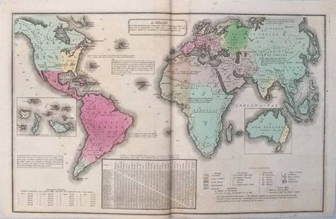
Sold20211835 Smith World Map -- A Chart Exhibiting the ActualTitle: 1835 Smith World Map -- A Chart Exhibiting the Actual and Comparative Size of each Country, Nation, or Kingdom; its Population as a Whole and to a Square Mile. Also the Different States of SociSee Sold Price
Sold2023Vyse, Charles 1805 Antique Map. World HemipsheresCopper Engraved Map Published 1805 (Map dated 1799) London for "Geography for Youth. A New Grammar: Containing A Comprehensive System of Modern Geography…" by Charles Vyse. Folds as issued, Paper SiSee Sold Price
Sold20231854 MAPS Atlas 1ed World in Middle Ages CRUSADES Rome Ottoman Medieval Koeppen1854 MAPS Atlas 1ed World in Middle Ages CRUSADES Rome Ottoman Medieval Koeppen Adolph Ludwig Koeppens “World in the Middle Ages” is a rare, 19th-century perspective on the state of the woSee Sold Price
Sold2017Smith: Antique Map of the World, 1835Map: 1835 Smith World Map -- A Chart Exhibiting the Actual and Comparative Size of each Country, Nation, or Kingdom; its Population as a Whole and to a Square Mile. Also the Different States of SocietSee Sold Price
Sold2020C. Agar & J. Maiden Victorian 1840 Horse EtchingCharles Agar (English, 1782-1854) & Joseph Maiden (English, 1813-1843). A large and exemplary antique Victorian equestrian etching, titled "The Bury Hunt," featuring an Early Victorian hunting landscaSee Sold Price
Sold20221809 map of Macedonia and Thracia by SmithMacedonia et Thracia by Charles Smith. Finely detailed map shows coastal features, topographical details, rivers, Original hand coloring. Few repaired small tears at upper margin. 10.25 x 13.75 ReservSee Sold Price
Sold20211997 Australian Six-Coin Proof Set1997 Australian Six-Coin Proof Set commemorating 100 years since the birth of Sir Charles Kingsford Smith, the World's greatest pioneering aviatorSee Sold Price
Sold20201855 Smith’s ATLAS Geography 36 BEAUTIFUL Colored MAPS1855 Smith’s ATLAS Geography 36 BEAUTIFUL Colored MAPS World ‘Smith’s Atlas of Modern and Ancient Geography’ is a collection of maps focusing on the United States, but includes maps of the worSee Sold Price
Sold2019Charles Magnus New York 1854 MapMap of the State of New York, Charles Magnus, 1854. Engraving. 21" x 26".See Sold Price
Sold2024English Mahogany World Map Coffee Table c.1950'sEnglish Mahogany World Map Coffee Table c.1950's - 14.5 in tall x 52.5 x 27See Sold Price
Sold2023"Orbis Romani Pars Occidentalis" Framed Antique Map by Charles Smith c1820s"Orbis Romani Pars Occidentalis" Framed Antique Map by Charles Smith c1820s.See Sold Price
Sold2018UK - Staffordshire 1808 Hand Col Map by Charles Smith"A New Map of the County of Stafford" Copper Engraved Map Published 1808, London. Printed for C. Smith. Dissected and linen backed. Original hand colour. Paper Size: 20.5 x 19 inch (52 x 48cm) Good coSee Sold Price
Sold20191854 Johnston Rain Map of the World -- Hyetographic orTitle/Content of Map: 1854 Johnston Rain Map of the World -- Hyetographic or Rain Map of the World Date: 1854, EdinburghCartographer: W & A Johnston Size: 19 X 24 in. This is a very nice large map illSee Sold Price
Sold20231888 Pocket Map1888 Pocket Map, paper on cloth, "Topography New Jersey Princeton Quadrangle" U.S. geological survey, Charles and George Otis Smith, Directors, map folds into a book form. CONDITION: Separations of maSee Sold Price
Sold2018SMITH & WATSON COFFEE TABLE W/ MAP OF WORLD INLAYMarked Smith and Watson underneath. Dimensions: H 18" x W 49.5" x D 27.25" Condition: Crazing to finish. Some finish loss. Few surface scratches. Nicks and dings to leg edges. Wear consistent with ageSee Sold Price
Jun 02Schilb Antiquarian Rare Books1850 David Copperfield Charles Dickens English Literature Putnam EARLY US ed$1
5 days LeftHunt and Peck Estate Services, Inc.William Hole "A Description of the land of Gosen, and Moses passage though the Deserts"$50
3 days LeftJasper52Coastline of Cape Blanco, Patagonia, Argentina by Pirate G. Anson (1756)$20(1 bid)
3 days LeftMynt Auctions4V ENGLISH 1842 BOOKS OF ROTTECKS HISTORY OF THE WORLD BY CHARLES VON ROTTECK$10
3 days LeftJasper521756 Mexican port of Zihuatanejo, also known as Chequetan or Seguatanco, was depicted by the English$20(1 bid)
3 days LeftJasper521756 Acapulco coastline, Mexico, depicted by the English pirate G. Anson.$20(1 bid)
Featured3 days LeftJasper521756 The Remote Chilean Juan Fernandez Archipelago, Eastern Robinson Crusoe Island, by G. Anson$20(1 bid)
3 days LeftJasper521660 HISTORY of the WORLD by WALTER RALEIGH antique ILLUSTRATED w/ MAPS English$700
Jun 02Schilb Antiquarian Rare Books1897 History of British Empire England Scotland Canada James II MAPS India 6v$1
7 days LeftTrillium Antique Prints & Rare BooksCatesby, Folio - Kingfisher with Narrow Leaved Candleberry Myrtle. 1-69$200
7 days LeftTrillium Antique Prints & Rare BooksCatesby, Folio - Great Laurel & Narrow Leaved Laurel. Sup-17$200
7 days LeftTrillium Antique Prints & Rare BooksCatesby, Folio - Plumeria Flore Niveo (White Frangipanni). 2-93$200
7 days LeftTrillium Antique Prints & Rare BooksCatesby, Folio - Chain Snake with Climbing Hydrangea. 2-52$200