Sold2018Thomson: Antique Mpa of Egypt. Nile Valley, 1817TITLE/CONTENT OF MAP: 'Egypt' The map is noteworthy for showing the return route of Eyles Irwin, an Irish poet and civil servant, through Egypt from India, where he been in the service of the East IndSee Sold Price
Sold2022China.- Speed (John) The Kingdome of China newly augmented, 1626.China.- Speed (John) The Kingdome of China newly augmented, the only carte-a-figures map made of the region, showing China, Korea and Japan, with 8 costumed figures along the left and right borders, aSee Sold Price
Sold202334 Civil War Related Papers and PhotosA fine collection of Civil War documents from 1861 - 1922. Highlighting the collection is a manuscript map in a contemporary hand showing a "Map of the route marched by 5th Regt P.R.v.C.(?) Starts inSee Sold Price
Sold2022Rare 1836 Col. Dodge Expedition map - 1st printing, SteenLarge and important early copper engraved map of the western U. S. showing the route of Col. Henry Dodge’s 1835 Expedition from Fort Leavenworth to the Rocky Mountains. Rare first printing withSee Sold Price
Sold2015A map of China, Korea and the Japanese Isles, ca. 1779SANTINI, Paolo, L'Empire de la Chine, avec la Tartarie Chinoise d'aprs l'Atlas Chinois. Venice, Remondini, 1779. Original outline colour. 485 x 560mm. China, Korea and Tartary, also showing Japan andSee Sold Price
Sold2023George Catlin Indian Gallery [170312]This is a publication put out by the U.S. National Museum and authored by Thomas Donaldson. This 939 page book has an 1887 copyright. There are also several loose maps, showing the various tribal landSee Sold Price
Sold2015A MONUMENTAL ICON SHOWING ST. GEORGE FROM ANA MONUMENTAL ICON SHOWING ST. GEORGE FROM AN ICONOSTASIS Balkan, 18th century Tempera on wood panel. The youthful saint shown frontal, holding a sword and his shield. Attired in a Roman military unifoSee Sold Price
Sold2023G. Washington & Thomas Jefferson Signed Doc 1793George Washington & Thomas Jefferson signed Legal Document dated Febuary 8th, 1793. George Washington (February 22, 1732 - December 14, 1799) Thomas Jefferson (April 13, 1743 - July 4, 1826) George WaSee Sold Price
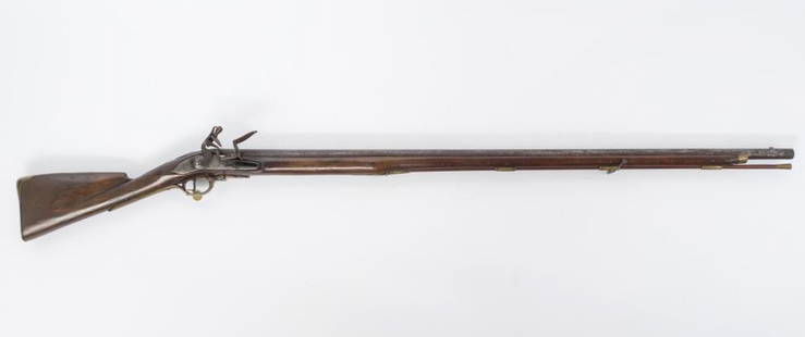
Sold2021British Brown Bess Musket, 18th CenturyA mid 18th century British Brown Bess flintlock musket, the distinctive 'banana' shaped lock plate stamped TOWER with a test date of 1743, together with the Royal Cypher for King George II, showing aSee Sold Price
Sold2021George III Figured Mahogany Eight Drawer Map CaseBritish, 18th century, in old surface with rich brown color, highly figured top over eight dovetailed drawers with oak linings, probably original gilt brass pulls, brass carrying handles, set on straiSee Sold Price
Sold2021Bowles View of Philadelphia, Heap and ScullRare 1778 Engraved map of Colonial Philadelphia after George Heap (1714-1752) and Nicholas Scull (1687-1761), published by Carington Bowles, London, 1778: AN EAST PERSPECTIVE VIEW OF THE CITY OF PHILASee Sold Price
Sold2022George Frederic Watts, OM, RA (British, 1817-1904) Design for a muralGeorge Frederic Watts, OM, RA (British, 1817-1904) Design for a mural oil on panel 25 x 61cm (9 13/16 x 24in). Footnotes: Provenance Lilian Mackintosh (later Chapman), Watts's adopteSee Sold Price
2021Vill Of Saug - SBL: 18.71-1-1 - Latham CirPARCEL #68 TOWN: SAUGERTIES ASSESSED TO: LIGHTHOUSE COVE INC CURRENT OWNER: SBL#: 018.071-0001-000.000-0000 SHOWN ON MAP AS 18.71-1-8, 18.71-1-9 18.71-2-7, 18.71-2-8, 18.71-2-9, 18.71-2-10, 18.71-2-11See Sold Price
Sold2021Town of Ulster - SBL: 56.17-1-5.200 - 2857 Route 32PARCEL #102 TOWN: ULSTER ASSESSED TO: SMITH KEVIN CURRENT OWNER: COUNTY OF ULSTER SBL#: 056.017-0001-005.200-0000 CLASSIFICATION: 270 LOCATION: 2857 ROUTE 32 ACREAGE: 1.60 FRONT FOOT: .00 DEPTH FOOT:See Sold Price
Sold2021Town of Saug - SBL: 8.4-5.23 - Old Route 32PARCEL #70 TOWN: SAUGERTIES ASSESSED TO: RUCKER HENRY D RUCKER MARY M CURRENT OWNER: COUNTY OF ULSTER SBL#: 008.004-0005-023.000-0000 CLASSIFICATION: 314 LOCATION: OLD ROUTE 32 ACREAGE: 1.50 FRONT FOOSee Sold Price
Sold2022TOLKIEN (J.R.R.) The Lord of the Rings, 3 vol., FIRST EDITION, FIRST IMPRESSIONS, George Allen a...TOLKIEN (J.R.R.) The Lord of the Rings, 3 vol., FIRST EDITION, FIRST IMPRESSIONS, with 'sagging text' on p.49 of 'The Return', each with a folding map printed in red and black, publisher's red clothSee Sold Price
Sold2018A PAIR OF PAUL STORR (British 1771-1844) GEORGE IIIA PAIR OF PAUL STORR (British 1771-1844) GEORGE III PERIOD STERLING SILVER CONVERTIBLE ENTRÉE SERVING DISHES WITH CAST HANDLES, LONDON, ENGLAND, 1816-1817, of rectangular domed form, the cover with gSee Sold Price
Sold2023GEORGE EDGAR OHR (AMERICAN, 1857-1918)George Edgar OhrAmerican, 1857-1918Art Pottery VaseEarthenware, incised signature underfootPinched pottery vase showing a partial matte glaze with fire damage - one of Ohr's "burned babes" sSee Sold Price
Sold2019China Missions, late 19th century, a small box ofChina Missions, late 19th century, a small box of various China Missionary items and ephemera, including a tissue paper map, passport to Rev. A W Nightingale expiring 1880, signed 'Bullock', printed sSee Sold Price
Sold2020Gem-Set Figure of St George and the DragonThe dragon with its Emerald set wings open its head turned to the rear showing its Cabochon ruby set neck with ruby eyes and an emerald set in its head. The body with a large Baroque pearl, St GeorgeSee Sold Price
Sold2022Rare Tony Sarg Colored Map of New Hope, Pennsylvania 1941Rare Tony Sarg (1880-1942) Colored Map of New Hope, Pennsylvania 1941, depicting George Washington crossing the Delaware River among other local points of interest 19 in. x 25 in. Framed 27.5 in. x 33See Sold Price
Sold2024George Frederic WattsBritish, 1817-1904Study for the Head of Noah for "Noah Building the Ark" from Dalziel's Bible Gallery Black and white chalk on brown paper14 1/2 x 11 5/8 inches (36.8 x 29.5 cm)Frame 24 3/4 x 21 5/8 iSee Sold Price
Sold2018George Thompson Pritchard (1878 - 1962)George Thompson Pritchard (California / United Kingdom, New Zealand, 1878 - 1962) Painting of a China Town Market scene with figures throughout. Signed lower right. Oil on Canvas. Sight Size: 28 x 33.See Sold Price
Sold20241740. Map of Isle de Juan Fernandes ''Robinson Crusoe Island'', Chile. George AnsonMap of Isle de Juan Fernandes ''Robinson Crusoe Island'', Chile. Title: L'Ile de Juan Fernandes dans la Mer du Sud à 33° 40'de latitude méridionale et à 110 lieues à l'ouest dSee Sold Price
5 days LeftArarity AuctionsThomson's 1817 Hand Colored Map Comparative Heights of the World's Great Mountains$50
52 mins LeftJasper521892 Cowles Civil War Map of Battles in Gettysburg, Virginia, W Virginia and Maryland -- Sketch of$75(2 bids)
Swann Auction GalleriesAusten, Jane (1775-1817) Pride and Prejudice, the Peacock Edition.$1,100(3 bids)
May 29Cedarburg Auction & Appraisals LLCSet of Four Maps Showing All of Spain and Portugal$375(2 bids)
2 days LeftSloans & KenyonTOTAL ECLIPSE OF THE SUN : SEE NIGHT-TIME WHEN ITS DAY IN NEW ENGLAND WHILE YOU PLAY JOHN HELD JR$1,000
BonhamsEDWARD GEORGE ARMFIELD (British, 1817-1896) What's for Supper? (framed 67.0 x 82.0 x 12.0 cm (26...$1,000(2 bids)
Featured52 mins LeftJasper52Johnson's New Military Map of the United States Showing the Forts, Military Posts &C. With Enlarged$65
Jun 16Broward Auction GalleryATTRIB George Forster (NY,German,1817-1896) oil painting antique$20(2 bids)
Jun 07Freeman's | Hindman[MORMONS]. MILLROY & HAYES (fl. 1899). Route of the Mormon Pioneers from Nauvoo to Great Salt Lake,$300
Jun 23Schilb Antiquarian Rare Books1877 Geology Geography Surveys 1ed Nevada Wyoming Utah George Wheeler US West 2v$1


![George Catlin Indian Gallery [170312]: This is a publication put out by the U.S. National Museum and authored by Thomas Donaldson. This 939 page book has an 1887 copyright. There are also several loose maps, showing the various tribal land](https://p1.liveauctioneers.com/2699/299063/159201542_1_x.jpg?height=310&quality=70&version=1692045182)


![[MORMONS]. MILLROY & HAYES (fl. 1899). Route of the Mormon Pioneers from Nauvoo to Great Salt Lake, (1 of 2)](https://p1.liveauctioneers.com/197/329395/177650560_1_x.jpg?height=282&quality=70&version=1715364962)

