Sold2022Rare Tony Sarg Colored Map of New Hope, Pennsylvania 1941Rare Tony Sarg (1880-1942) Colored Map of New Hope, Pennsylvania 1941, depicting George Washington crossing the Delaware River among other local points of interest 19 in. x 25 in. Framed 27.5 in. x 33See Sold Price
Sold2018NYC World's Fair 1939 Walking Cane w Tony Sarg MapNew York World's Fair 1939 walking cane, containing a 13" X 13" fabric pull-out Tony Sarg color map of the fairgrounds, rare. 35" H. Map pulls 3/4 out; usage wear to grip finish; cane lacking originalSee Sold Price
Sold20231926 Tony Sarg Colored Lithograph Map of Nantucket in the State of Massachusetts1926 Tony Sarg (1880-1942) Colored Lithograph Map of Nantucket in the State of Massachusetts, depicting founders of Nantucket Island and numerous landmarks, matted and framed Sight 16 in. x 18.5 in. OSee Sold Price
Sold2020George Nakashima (1905-1990), Fine and Rare MusicGeorge Nakashima (1905-1990) Fine and Rare Music Stand, New Hope, Pennsylvania, 1990 Walnut, rosewoodSigned and dated: "George Nakashima Feb 28 1990"H: 48 1/2, W: 33, D: 19 in. (as shown), H: 60 1/2 iSee Sold Price
Sold2022c 1760 Northern Colonies French + Indian War MapHistoric Maps Louisiana & Florida French & Indian War Era Map c. 1760 c. 1760 French & Indian War Era, Hand-Colored Map of Pennsylvania and New England titled, "Carte de la Partie Nord, Des Etats UnisSee Sold Price
Sold20231758 Bowen & Gibson 4 Atlas Minimus Maps1758 Bowen & Gibson Atlas Minimus Maps hand colored maps of New England, New York and Pennsylvania, Pennsylvania Maryland and Virginia, Carolina and Georgia. Beautiful small maps matted in acid free pSee Sold Price
Sold2022Rare Rev. War map of East Jersey/E. Penn., 1832Rare and desirable map of central New Jersey and eastern Pennsylvania during the American Revolutionary War drawn by Joseph Yeager for John Marshall’s 1832 edition of The Life of Washington. “MapSee Sold Price
Sold2017John Carey. North America map(English, 1754-1835). "Part of North America comprehending Ohio, New England, New York, New Jersey, Pennsylvania, Maryland, Virginia, Carolinas & Georgia" (sic) hand colored map, circa 1782, 9 1/2 x 1See Sold Price
Sold2018Western Hemisphere by Reinecke *RARE*Title/Content of Map: Western Hemisphere by Reinecke *RARE* Date: 1804 Cartographer: J.C. M. Reinecke Material/Medium: Paper Size: 27" x 23" Provenance: New York Rare hand colored engraved Map. PleaseSee Sold Price
Sold2017Bradford: Antique Map of Pennsylvania & New Jersey 1835Title/Content of Map: Pennsylvania & New Jersey Date Printed: 1835 Cartographer: T.G. Bradford Material/Medium: Paper Size: 13" x 10" Condition: Excellent Hand colored outlines. Published in PhiladelpSee Sold Price
Sold2017Johnson: Antique Map of Pennsylvania & New Jersey, 1868Title/Content of Map: Pennsylvania & New Jersey by Johnson Date Printed: 1868 Cartographer: A.J. Johnson Material/Medium: Paper Size: 24" x 18" Hand colored steel engraved Map. From Johnson's New IlluSee Sold Price
Sold2017Asher & Adams: Map of Pennsylvania & New Jersey, 1872Nicely colored Asher & Adams Pennsylvania and New Jersey. 1872. 15.75 x 22.75. Striking example of an Asher & Adams map which are often pale in hand coloring, or somewhat brittle. This one is nicely cSee Sold Price
Sold1939 New York World's Fair Official World's Fair Pictorial Map1939 New York Worlds Fair Official Worlds Fair Pictorial Map by Tony Sarg in very good to excellent condition as seen in the photos.See Sold Price
Sold2020Pennsylvania, New Jersey, Maryland & DelawareTitle: Pennsylvania, New Jersey, Maryland & Delaware Description: By Augustus S. Mitchell. Hand colored engraved map. From ‘the New General Atlas’. Published in Philadelphia. Date/Period: 1862 MatSee Sold Price
Sold2020Johnson's Pennsylvania & New JerseyJohnson's Pennsylvania and New Jersey, published by AJ Johnson, New York. Colored map showing towns, townships, major cities, railroads and topography. 1870. Pages 35 - 36. Has some staining to the edSee Sold Price
Sold2021A Mid 19th Century Map, Pennsylvania"A New Map of Pennsylvania with its Canals, Rail-Roads, Etc..." published by Thomas Cowperthwait and Co. Philadelphia. Hand colored. Dimensions: Sight is 12" x 14 1/2". Provenance: From a PhiladelphiaSee Sold Price
Sold2019Samuel Augustus Mitchell (1790-1868), "County Map ofSamuel Augustus Mitchell (1790-1868), "County Map of Pennsylvania, New Jersey, Maryland and Delaware," 1860, hand colored, H. -12 3/4 in., W. - 15 3/8 in.See Sold Price
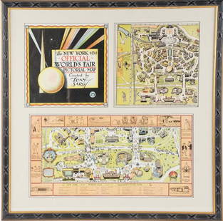
Sold2022Framed Tony Sarg 1939 World's Fair Pictorial MapTony Sarg (American, 1880-1942), "The New York 1939 Official World's Fair Pictorial Map Created by Tony Sarg 25¢" cover and Transportation Zone maps, three pieces matted and under glass in paintedSee Sold Price
Sold20221846 Pre civil war middle states. By MitchellTitle: 1846 Pre civil war middle states. By Mitchell Date/Period: 1846 Materials: Hand colored engraved Size: 11 1/2 x 17 1/2" Pre civil war maps shows New York, New Jersey, Pennsylvania, Delaware, MaSee Sold Price
Sold2024Very Rare Mexico Nova Hispania 1579 Hand Colored MapORTELIUS, Abraham (1527-1598). Theatrum Orbis Terrarum. 1570. It is considered to be the first modern atlas. Map of New Spain (Mexico), 1579. Printed in Antwerp by Christophe Plantin (1588). Etching.See Sold Price
Sold2021A Map of Pennsylvania and New JerseyCirca 1830, hand colored. Engraved and printed by Fenner Sears and Co. Dimensions: Sight is 10" x 15 1/2", the frame 19" x 24". Provenance: From a Philadelphia collection.See Sold Price
Sold2020Pieced and embroidered presentation bedspread, New HopePieced and embroidered presentation bedspread New Hope Baptist Church, Denver, Colorado, dated "1941" Worked in various colored threads and yarns with church building and names of ministers, deacons,See Sold Price
Sold2023Burr - Map of North AmericaThis hand-colored map is from David H. Burr's A New Universal Atlas; comprising separate maps of all the principal empires, kingdoms & states throughout the world: and forming a distinct atlas of theSee Sold Price
Sold2021Pennsylvania 19th Century Maps (2)The first is a Pennsylvania, New Jersey, and Delaware folding map dated 1848 published by S. Augustus Mitchell with colored counties. It has close ups of Pittsburg, Lehigh & Schuylkill, Philadelphia,See Sold Price
4 days LeftTrillium Antique Prints & Rare BooksMitchell's A New Universal Atlas.. - Volume with 73 Maps$1,000(1 bid)
20 hrs LeftAdam's AuctioneersA COLLECTION OF NURSERY BOOKS Comprising: KINGSLEY, C., The Water-Babies, New York (Dodd, Mead &€150
4 days LeftTrillium Antique Prints & Rare BooksCarey, pub. 1814 - Map of New South Wales, Australia$50
24 hrs LeftDoyle New YorkA highly detailed map of New England after the Jansson-Visscher series$250(2 bids)
24 hrs LeftDoyle New YorkVaugondy's map of Virginia and Maryland, a reduction of Fry and Jefferson's landmark map$600


![[MAP - TOURS] (1 of 1)](https://p1.liveauctioneers.com/292/326828/175962850_1_x.jpg?height=282&quality=70&version=1713473479)


