Sold2018Coste de Coromandel depuis Gondagamas jusqu'aTITLE/CONTENT OF MAP: 'Coste de Coromandel depuis Gondagamas jusqu'a Narzapour; Mazulipatam' The map depicts part of the Coromandel coast from Narsapur and the Godavari River estuary southwards, incluSee Sold Price
Sold2019Isles du Japon & presquIsle de Corée'. Japan KoreaTITLE/CONTENT OF MAP: 'Carte des Isles du Japon et la Presqu Isle de Corée, avec les Costes de la Chine, depuis Pékin jusquà Canton [Map of the Islands of Japan, and the peninsula of Korea, with thSee Sold Price
Sold20211773 Bellin Map of Japan, Korea and Coastal China --Title: 1773 Bellin Map of Japan, Korea and Coastal China -- Carte des Isles du Japon et la Presqu Isle de Coree avec les Costes de la Chine Depuis Pekin Jusqua Canton Cartographer: J Bellin Year / PlaSee Sold Price
Sold2023MAP, China, BellinChina, Korea & Japan. Jacques Nicolas Bellin, Carte des Isles du Japon et la Presqu' Isle de Coree avec les Costes de la Chine Depuis Pekin Jusqua Canton, from Prevost's Histoire Generale des Voyages�See Sold Price
Sold2018Bellin: Guinea Coast 3–the Gold Coast (Ghana)Reserve Reduced! Map Title: Suite de la Coste de Guinee depuis le Cap Apollonia jusqu’a la Riviere de Volta ou la Coste d'Or Cartographer: Bellin Place / Date: Paris / 1747/1760 Size: 17" x 18 7/8"See Sold Price
Sold2018Bellin: Guinea Coast 4–the Slave Coast (Ghana to Benin)Reserve Reduced! Map Title: Suite de la Coste de Guinee depuis la Riviere de Volta jusqu'a Jakin ou sont les royaumes de Koto, de Popo, de Whidah ou Juida, et d'Ardra Cartographer: Bellin Place / DateSee Sold Price
Sold2023MAP, Southern USA, BellinColonial Southern United States. Jacques Nicolas Bellin, Partie de la Coste de la Louisiane et de la Floride Depuis le Mississipi Jusqua St. Marc d'Apalache Dressee sur les Manuscrits du Depost des PlSee Sold Price
Sold2024Coste Occidentale d’Afrique…' Namibia South Africa Angola coast BELLIN 1746 mapCAPTION PRINTED BELOW PICTURE: Carte de la Côte Occidentale d’Afrique depuis le Xle. degré de Latitude Meridionale, jusqu’au Cap de Bonne Esperance, Tirée de la Carte de l'OSee Sold Price
Sold20211760 Map Theatre Guerre Coromandel IndiaFolding map "Theatre De La Guerre Sur la Coste de Coromandel", by Jacques Nicolas Bellin, cirac 1760, printed at Paris. Fine condition, measures 10 x 15.75". Reserve: $20.00 Shipping: Domestic: Flat-rSee Sold Price
Sold20201746 Bellin Coastal Map of Sierra Leone and Liberia inTitle: 1746 Bellin Coastal Map of Sierra Leone and Liberia in Western Africa During the Slave Trade Period -- Partie de la Coste de Guinée Depuis la Riviere de Sierra Leona Jusquau Cap das Palmas YeaSee Sold Price
Sold2018Bellin: Guinea Coast 2–Liberia to GhanaReserve Reduced! Map Title: Suite de la Coste de Guinee depuis le Cap de Palme Cartographer: Bellin Place / Date: Paris / 1746/1760 Size: 11 1/8" x 8" Condition: b&w light overall age toning; some minSee Sold Price
Sold2018Bellin: Guinea Coast 1–Sierra Leone to LiberiaReserve Reduced! Map Title: Partie de la Coste de Guinee Depuis la Riviere de Sierra Leona Jusquau Cap das Palmas Cartographer: Bellin Place / Date: Paris / 1746/1760 Size: 13" x 9" Condition: b&w ligSee Sold Price
Sold20221761 Map of Carthage as Part of Roman Empire EtcHistoric Maps 1761 Map: "SUITE DE L'HISTOIRE DE CARTHAGE,..." 1761-Dated French & Indian War Period, Hand-Colored Map fully titled, "SUITE DE L'HISTOIRE DE CARTHAGE, DEPUIS L'AN 3786 JUSQU'A L'AN 3860See Sold Price
Sold20201760 Bellin Map of St Lawrence RiverEngraved map of Jacques Bellin circa 1752 entitled "Suite Du Cours Du Fleuve De St. Laurent Depuis Quebec jusqu u Lac Ontario" from his work "L'Historie Generale des voyages". Printed at Paris measureSee Sold Price
Sold2023Vanel Histoire de Conclaves Depuis Clement VVanel, Claude. "Histoire de Conclaves Depuis Clement V. Jusqu'a Present". Paris; Claude Barbin, MDCLXXXIX (1689). Full speckled calf with raised bands and sprinkled edges, 4to (10" high). Some wear anSee Sold Price
Sold2017Bellin: Plan of Malacca City/Tonkin River Basin ChartMap: Plan de la Ville et Forteresse de Malaca [and on the same sheet] Carte du Cours de la Riviere de Tunquin [Tonkin] Depuis Cacho jusqu'a la Mer Cartographer: Bellin Place & Date: Paris / 1750/1760See Sold Price
Sold2019Isles du Japon & presquIsle de Corée. Japan Korea ChinaTITLE/CONTENT OF MAP: 'Carte des Isles du Japon, & la Presqu Isle de Corée, avec les Côtes de la Chine, depuis Pékin jusquà Canton [Map of the Islands of Japan, and the peninsula of Korea, with thSee Sold Price
Sold2017Bellin: Antique Map of Saint Lawrence River, 1764Title/Content of Map: 'Cours du Fleuve de Saint Laurent depuis la mer jusqu'à Quebec [Course of the Saint Lawrence river from the sea to the city of Quebec]' A map of the St Lawrence river estuary anSee Sold Price
Sold2019Carte du cours du fleuve de St Laurent' St LawrenceTITLE/CONTENT OF MAP: 'Carte du cours du fleuve de St Laurent, depuis sont embouchure jusqu'au dessus de Québec [Map of the course of the St Lawrence river from its mouth to above Quebec]' DATE PRINTSee Sold Price
Sold20191754 Bellin Map of Saint Lawrence River From Quebec --Title: 1754 Bellin Map of Saint Lawrence River From Quebec -- Carte du Cours du Fleuve de St. Laurent Depuis son Embouchure jusqu'au Dessus de Quebec Date: 1754, Paris Medium: J Bellin Size: 7.5 X 11.See Sold Price
Sold20181757 Bellin Map of Eastern and Central Canada --Title/Content of Map: 1757 Bellin Map of Eastern and Central Canada -- Carte du Cours du Fleuve de St. Laurent Depuis son Embouchure jusqu'au dessus de Quebec Date: 1757, Paris Cartographer: J BellinSee Sold Price
Sold20221757 Bellin Map of Eastern Canada Along the St. Lawrence River -- Carte du Cours du Fleuve de St.Title: 1757 Bellin Map of Eastern Canada Along the St. Lawrence River -- Carte du Cours du Fleuve de St. Laurent Depuis son Embouchure jusqu'au dessus de Quebec. Cartographer: J Bellin Year / Place: 1See Sold Price
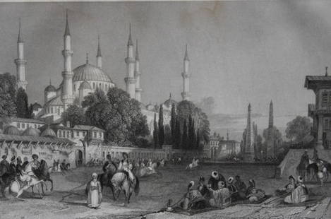
Sold2024Hippodrome, Constantinople by T Allom 1855This engraving is from Histoire de l'Empire Ottoman depuis anciens jusqu’a nos jours (History of the Ottoman Empire from ancient times to the present day) by Theophile Lavallee. Published by GarnierSee Sold Price
Sold20221780 Bonne Map of Western African Coast -- Partie Occidentale De L'Ancien Continent, Depuis LisbonneTitle: 1780 Bonne Map of Western African Coast -- Partie Occidentale De L'Ancien Continent, Depuis Lisbonne Jusqu'a La Riviere De Sierra Leona: Avec l'Isle Madere, les Isles Canaries, et celles du VerSee Sold Price
May 30The Rug LifeHISTOIRE ECCLESIASTIOUE DEPUIS LA CREATION JUSQU'AU PONTIFICAT DE PIE IX – 27 VOLUMES –$500
3 days LeftTrillium Antique Prints & Rare BooksPrevost - Chart of the Gulf of Mexico (with Florida & Lousiana)$50(1 bid)
6 days LeftJasper521670 CULT of WITCHCRAFT RELIGIOUS CEREMONIES in INDIA antique ILLUSTRATED rare$550
1 day LeftLA INDEPENDENCIA CASA DE SUBASTAS & ANTICUARIOHERBERT BAYER (1900-1985, Austria) Sin Titulo, sf.COP 1,800,000(1 bid)


![Bellin: Plan of Malacca City/Tonkin River Basin Chart: Map: Plan de la Ville et Forteresse de Malaca [and on the same sheet] Carte du Cours de la Riviere de Tunquin [Tonkin] Depuis Cacho jusqu'a la Mer Cartographer: Bellin Place & Date: Paris / 1750/1760](https://p1.liveauctioneers.com/5584/105261/53910605_1_x.jpg?height=310&quality=70&version=1497542970)

![Bellin: Antique Map of Saint Lawrence River, 1764: Title/Content of Map: 'Cours du Fleuve de Saint Laurent depuis la mer jusqu'à Quebec [Course of the Saint Lawrence river from the sea to the city of Quebec]' A map of the St Lawrence river estuary an](https://p1.liveauctioneers.com/5584/110975/56961948_1_x.jpg?height=310&quality=70&version=1508432804)
![Carte du cours du fleuve de St Laurent' St Lawrence: TITLE/CONTENT OF MAP: 'Carte du cours du fleuve de St Laurent, depuis sont embouchure jusqu'au dessus de Québec [Map of the course of the St Lawrence river from its mouth to above Quebec]' DATE PRINT](https://p1.liveauctioneers.com/5584/144578/73088287_1_x.jpg?height=310&quality=70&version=1561513819)