Sold2021County map of Florida/Map of S. Carolina, 1860/66Vivid hand coloring makes this Civil War era map really stand out. The map, created in 1860, was used for several years in subsequent editions of Mitchell’s New General Atlas. This one is from MSee Sold Price
Sold2023Rare 1st state of Florida map from 1st printing of 1860 atlasFirst edition, first state of S. A. Mitchell Jr.'s County Map of Florida/County Map of South Carolina. Maps from Mitchell Jr’s first printing of his first New General Atlas are distinguished bySee Sold Price
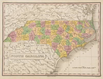
Sold2019Samuel Augustus Mitchell (1790-1868), "County Map ofSamuel Augustus Mitchell (1790-1868), "County Map of Florida, North Carolina, South Carolina," 1860, H. - 12 1/4 in., W. - 15 3/8 in.See Sold Price
Sold2017Mitchell: Antique Map of Florida & South Carolina, 1860Map: 1860 Mitchell Map of Florida and South Carolina -- County Map of Florida [on sheet with] County Map of South Carolina Date Printed: 1860, Philadelphia Cartographer: S Mitchell Size: 9.1 x 10.6 inSee Sold Price
Sold2017Mitchell Map of Florida, South and North Carolina, 1860Title: 1860 Mitchell Map of Florida, South and North Carolina Cartographer: S Mitchell Published: 1860, Philadelphia Measurements: 10.6 X 13.5 in. County Map of Florida on page with Map of South CarolSee Sold Price
Sold20201860 Mitchell Map of Florida, South and North CarolinaTitle/Content of Map: 1860 Mitchell Map of Florida, South and North Carolina -- County Map of Florida on page with Map of South Carolina, on page with County Map of North Carolina Cartographer: S MitcSee Sold Price
Sold20231860 Mitchell Map of Florida, South and North Carolina -- County Map of Florida on page with Map ofTitle: 1860 Mitchell Map of Florida, South and North Carolina -- County Map of Florida on page with Map of South Carolina, on page with County Map of North Carolina Cartographer: S Mitchell Year / PlaSee Sold Price
Sold20211860 Mitchell Map of Florida, South and North CarolinaTitle: 1860 Mitchell Map of Florida, South and North Carolina -- County Map of Florida on page with Map of South Carolina, on page with County Map of North Carolina Cartographer: S Mitchell Year / PlaSee Sold Price
Sold20181860 Mitchell Map of Florida, South and North CarolinaTitle/Content of Map: 1860 Mitchell Map of Florida, South and North Carolina -- County Map of Florida on page with Map of South Carolina, on page with County Map of North Carolina Date Printed: 1860,See Sold Price
Sold20201860 Mitchell Map of Florida, South and North CarolinaTitle/Content of Map: 1860 Mitchell Map of Florida, South and North Carolina -- County Map of Florida on page with Map of South Carolina, on page with County Map of North Carolina Date: 1860, PhiladelSee Sold Price
Sold20191860 Mitchell Map of Florida and South Carolina --Title/Content of Map: 1860 Mitchell Map of Florida and South Carolina -- County Map Of Florida [on sheet with] Map Of South Carolina Date: 1860, PhiladelphiaCartographer: S Mitchell Size: 10.8 x 13.2See Sold Price
Sold2018Two Civil War Era Mitchell MapsMap of North America Showing Its Political Divisions and county maps of North Carolina, South Carolina, and Florida on one sheet (Philadelphia: S. Augustus Mitchell, 1860). Not framed. 15.25 x 12.25 iSee Sold Price
Sold2019Eight (8) Augustus Mitchell MapsCollection of eight maps including New Jersey/Maryland Delaware 1872, Two north and South Carolina 1872 maps (15" x 12"), Minnesota 1890 , Florida and the Carolinas 1860, County map of the state of ArSee Sold Price
Sold20241860 County Map of TexasVintage county map of Texas, 1860, hand-colored engraving sight: 12 x 14.5 in., frame: 22 x 24 in. Shipping available for this lot through our partner 4CL; please request a shipping quote at shippinSee Sold Price
Sold20171860 County Map of California1860 County Map of California Inset showing settlements in Great Salt Lake County. S. Augustus Mitchell, Jr. Engraved map with original hand-coloring by counties. Beautiful map of California with inseSee Sold Price
Sold2023An 1860 Map, Counties of New York, New Hampshire, Etc...Hand colored lithograph, by Samuel Augustus Mitchell (1790-1868). :County Map of the States of New York, New Hampshire, Vermont, Massachusetts, Rhode Island and Connecticut". Dimensions:15 1/2" x 23 1See Sold Price
Sold2023Anthony Finley North Carolina Counties MapA Anthony Finley (American, 1784-1834) handcolored engraving depicting the counties within North Carolina and the surrounding areas. Stamped 'Published By A. Finley Phliad.' lower center. Presented inSee Sold Price
Sold20181863 Mitchell Map of Florida, South and North CarolinaTitle/Content of Map: 1863 Mitchell Map of Florida, South and North Carolina -- County Map of Florida on page with Map of South Carolina, on page with County Map of North Carolina Date: 1863, PhiladelSee Sold Price
Sold20181867 Mitchell Map of North and South Carolina -- CountyTitle/Content of Map: 1867 Mitchell Map of North and South Carolina -- County Map of North and South Carolina Date: 1867, Philadelphia Cartographer: S Mitchell Size: 11.5 x 13.8 in. This is a handsomeSee Sold Price
Sold20211884 North Carolina MapAuthor: Cram Title: 1884 North Carolina Map Medium: Ink on Paper Dimensions: 14"X11" Rail Road and county Map of North Carolina dated 1884. Printed and published by George Cram in Chicago. Part of hisSee Sold Price
Sold20241860 Framed County Map of Texas1860 framed County map of Texas, hand colored sight: 12 in. x 14 in., frame: 17 in. x 19.5 in. Shipping available for this lot through our partner 4CL; please request a shipping quote at shipping&#See Sold Price
2018SUSSEX COUNTY NEW JERSEY MAP, HOPKINS 1860SUSSEX COUNTY NEW JERSEY MAP, HOPKINS 1860 57" X 53"See Sold Price
Sold2023Rare 1st edition/1st state of County Map of Maine, Mitchell 1860From the exceptionally rare first printing of the 1860 New General Atlas by Samuel Augustus Mitchell Jr. This was Mitchell Jr’s first project after taking over his father’s business and heSee Sold Price
Sold2022County Map of California, Mitchell 1860Lovely hand-colored map of California during the Civil War era. One of the earliest maps of California to appear in an American Atlas. Shows California divided into counties, showing all major towns aSee Sold Price
2 days LeftSwann Auction GalleriesVARIOUS CARTOGRAPHERS Group of 5 nineteenth-to-twentieth-century maps. 1835-1939.$450
17 hrs LeftJasper521874 Mitchell Map of Mississippi, Louisiana and Arkansas -- County Map of the States of Arkansas$40
2 days LeftJasper52Merioneth Shire Described county map by John Speed. George Humble edition 1627$380
2 days LeftJasper52Yorkeshyre. Yorkshire West Riding county map by John Speed. Overton edition 1710$850
2 days LeftJasper52Westmoria Comitatus; Anglice Westmorland. Westmoreland county map by Blaeu 1645$300
2 days LeftJasper52Shropshyre. Shropshire county map by John Speed. Bassett & Chiswell edition 1676$380
2 days LeftJasper52Darbieshire. Derbyshire county map by John Speed. Bassett/Chiswell edition 1676$460
2 days LeftJasper52Darbieshire. Derbyshire county map by John Speed. Bassett/Chiswell edition 1676$460
2 days LeftJasper52Countie of Lyncolne. Lincolnshire county map by Speed. Bassett/Chiswell ed. 1676$500
2 days LeftJasper52Suffolke described. Suffolk county map by John Speed. George Humble edition 1611$500


![Mitchell: Antique Map of Florida & South Carolina, 1860: Map: 1860 Mitchell Map of Florida and South Carolina -- County Map of Florida [on sheet with] County Map of South Carolina Date Printed: 1860, Philadelphia Cartographer: S Mitchell Size: 9.1 x 10.6 in](https://p1.liveauctioneers.com/5584/109294/56069180_1_x.jpg?height=310&quality=70&version=1505338533)


![1860 Mitchell Map of Florida and South Carolina --: Title/Content of Map: 1860 Mitchell Map of Florida and South Carolina -- County Map Of Florida [on sheet with] Map Of South Carolina Date: 1860, PhiladelphiaCartographer: S Mitchell Size: 10.8 x 13.2](https://p1.liveauctioneers.com/5584/144953/73284299_1_x.jpg?height=310&quality=70&version=1562102885)